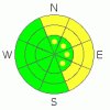
BOTTOM LINE
Danger by aspect and elevation on slopes approaching 35° or steeper.
(click HERE for tomorrow's danger rating)
|

Danger Rose Tutorial
|
The Bottom Line for today will be an Avalanche Danger of Moderate at and above tree-line for hard wind slabs on all aspects and below tree line for persistent weak layers on North-East aspects.
|
|
|
CURRENT CONDITIONS |

|
In solidarity with the Avalanche Accident, the mountains of southeast Utah have been wind scoured, wind deposited and sun crusted. To add insult to injury, the last "storm" brought 40 mph average winds and only 1 cm at the Gold Basin study plot, bringing the total snow on the ground to 56" (140 cm). Your best respite for spongy, consolidated powder is in wind sheltered, below tree line glades that did not receive the brunt of the winds...of course if you head into terrain below treeline greater than 35 degrees, avalanche dragons will need to be mitigated.
The good news is that LUNAvolunteers are heading up today (Friday) to groom the entire track. We can only hope that warm temperatures will bloom a corn cycle. |
|
|
RECENT ACTIVITY |

|
On yesterday's tour, we only received past activity on easterly and northerly aspects at and above tree line. The avalanche activity occurred before the last wind storm because avalanche paths are filled in with a smooth ominous chalk looking appearance...an indicator of a hard wind slab. |
|
|
THREAT #1 |

|
| WHERE |
PROBABILITY |
SIZE |
TREND |

|
|
|
|
|
|
The winds have really damaged at and above tree line locations. There's two types of conditions in the alpine currently...scoured to the scree or hard wind slabs. Ridges have verglas or sastrugi. The danger with hard slabs is that can break above you, move fast and be triggered from thinner areas of the snow. |
|
|
THREAT #2 |

|
| WHERE |
PROBABILITY |
SIZE |
TREND |
|
|
|
|
| |
|
|
Over the next
48 hours.
|
|
|
In the grand scheme of snow pack, the La Sal and Abajo mountain range would still classify as below average. The La Sal mountains climbed to 86% of snow water equivalent and the Abajo's are hovering around 90%. Shallow snow on shady aspects are slower to stabilize than sunny south aspects. As a result, persistent weak layers may exist in at or below tree line locations. |
|
|
MOUNTAIN WEATHER |

|
@ 10,000' in Gold Basin, La Sal Mountains Utah
Today: Sunny, with a high near 36. North northeast wind 5 to 10 mph becoming south.
Tonight: Clear, with a low around 23. South southeast wind between 5 and 10 mph.
Saturday: Sunny, with a high near 39. East southeast wind 5 to 10 mph becoming west.
Saturday Night: Mostly clear, with a low around 23. West wind 5 to 15 mph becoming southeast.
Sunday: Sunny, with a high near 41. Southeast wind 5 to 10 mph becoming southwest.
Sunday Night: Mostly clear and breezy, with a low around 25.
Monday: Sunny and breezy, with a high near 41.
|
|
|
This information does not apply to developed ski areas or highways where avalanche control is normally done. This advisory is from the U.S.D.A. Forest Service, which is solely responsible for its content. This advisory describes general avalanche conditions and local variations always occur. |
|
This advisory provided by the USDA Forest Service, in partnership with:
The Friends of the Utah Avalanche Center, Utah Division of State Parks and Recreation, Utah Division of Emergency Management, Salt Lake County, Salt Lake Unified Fire Authority and the friends of the La Sal Avalanche Center. See our Sponsors Page for a complete list. |
