SPECIAL ANNOUNCEMENT |
 |
LUNAwent up yesterday and rolled the entire track! Nordic skiing is back...expect another round of grooming to occur on Friday. |
|
|
BOTTOM LINE
Danger by aspect and elevation on slopes approaching 35° or steeper.
(click HERE for tomorrow's danger rating)
|
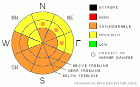
Danger Rose Tutorial
|
The Bottom Line for today will be an avalanche danger of Considerable in the mountains of southeast Utah at all elevations and most aspects due to soft wind slabs, persistent weak layers and wet point releases.
Choose the terrain you travel in and under wisely and keep the Human Factor in check. |
|
|
CURRENT CONDITIONS |

|
Our thoughts go out to the friends and family of everyone that was involved in the avalanche accident in Beaver Basin over the weekend. Click HERE to get a detailed report of the accident.
Grand and San Juan County road departments have been busy keeping the roads to access point in good shape. Thank you for your efforts!
Snow conditions are pretty nice out there in shady, wind sheltered locations where creamy powder exists. The sun has been out for two days strong...expect sun crust and maybe even some corn on sunny aspects that receive the most direct solar gain. |
|
|
RECENT ACTIVITY |

|
This past weekends avalanche event was isolated to east and southeast facing terrain. If you see an avalanche, please go to "Submit an Observation" link on the left hand side of the menu.
Click HERE to see a photo of a large avalanche in Dark Canyon on the east side of Laurel Peak. |
|
|
THREAT #1 |

|
| WHERE |
PROBABILITY |
SIZE |
TREND |

|
|
|
|
| |
|
|
Over the next
48 hours.
|
|
|
There are impregnated winds pillow at an above tree line on leeward sides of slopes and ridges from the last wind event from the northwest. Cross loading will also be a concern. |
|
|
THREAT #2 |

|
| WHERE |
PROBABILITY |
SIZE |
TREND |

|
|
|
|
| |
|
|
Over the next
48 hours.
|
|
|
Persistent weak layers still exist in the mountains of southeast Utah. Although there is a general stability trend with these layers, areas that are not visited frequently may have preserved these weak layers better than other places.
Be especially careful below treeline where the thin snow pack now has a considerable snow load on top of it. |
|
|
THREAT #3 |

|
| WHERE |
PROBABILITY |
SIZE |
TREND |

|
|
|
|
| |
|
|
Over the next
24 hours.
|
|
|
Another hot day on tap in the mountains will create wet loose point releases in the mountains. |
|
|
MOUNTAIN WEATHER |

|
@ 10,000' in Gold Basin, La Sal Mountains Utah Today: Sunny, with a high near 41. South southwest wind between 5 and 10 mph. Tonight: Partly cloudy, with a low around 26. Breezy, with a south southwest wind between 15 and 20 mph. Tuesday: Areas of blowing dust after 11am. Mostly sunny, with a high near 46. Windy, with a south southwest wind between 20 and 30 mph, with gusts as high as 50 mph. Tuesday Night: A 30 percent chance of snow. Mostly cloudy, with a low around 17. Breezy, with a south wind between 15 and 20 mph. Wednesday: Snow likely, mainly after 11am. Cloudy, with a high near 29. Breezy, with a south southwest wind between 15 and 20 mph. Chance of precipitation is 70%. |
|
|
This information does not apply to developed ski areas or highways where avalanche control is normally done. This advisory is from the U.S.D.A. Forest Service, which is solely responsible for its content. This advisory describes general avalanche conditions and local variations always occur. |
|
This advisory provided by the USDA Forest Service, in partnership with:
The Friends of the Utah Avalanche Center, Utah Division of State Parks and Recreation, Utah Division of Emergency Management, Salt Lake County, Salt Lake Unified Fire Authority and the friends of the La Sal Avalanche Center. See our Sponsors Page for a complete list. |
