BOTTOM LINE
Danger by aspect and elevation on slopes approaching 35° or steeper.
(click HERE for tomorrow's danger rating)
|
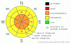
Danger Rose Tutorial
|
The Bottom Line for today will be an avalanche danger of Considerable on steep slopes greater than 35 degrees that have recent wind loading on all aspects at and above tree line. Please read on to get a full story on the state of affairs in southeast Utah. |
|
|
CURRENT CONDITIONS |

|
Very interesting situation we find ourselves here in southeast Utah! While the Abajo Mountain range only picked up a few inches in the past 5 days to bring the total snow on the ground at Camp Jackson to 44", the La Sal Mountains picked up 25" (62 cm) in the same time frame in Gold Basin, bringing the total height of snow to 70" (175 cm).
Winds have been howling at and above tree line locations starting from the southwest and veering to the current northerly direction on Pre-Laurel Peak and out of the WNW on Abajo Peak. Averages have been in the mid-twenties and have definitely caused a significant avalanche cycle on numerous slopes in the La Sal mountains.
Thanks to San Juan County to their tremendous effort keeping the trail heads clear at all access points! LUNA has been awaiting a break in the weather to groom. The best opportunity to recreate in the mountains will be on low angled slopes less than 34 degrees on all aspects, in below tree line locations where the wind has not affected the snow and stability is trending towards good.
The Human Factor will have to be placed in check today. Blue Sky Syndrome, powder fever and a trend towards stability are a few factors that will need to be put in check, especially when combined with the itch to get to ski some of the more rowdy lines. Hold Back! Spring is almost here. |
|
|
RECENT ACTIVITY |

|
On the flip side to snow conditions becoming more stable below tree line, at and above tree line locations are still a bit tenuous. Winds have caused avalanches in Exxon's Folly and in Red Snow Cirque to name a few locations spotted in the poor visibility in the past 48 hours. Today will be a great day to get some more avalanche observations. Please send them in using the "Submit a snow observation" link on the left-hand menu. They help! |
|
|
THREAT #1 |

|
| WHERE |
PROBABILITY |
SIZE |
TREND |

|
|
|
|
| |
|
|
Over the next
48 hours.
|
|
|
Wind slabs will be the biggest concern at and above tree line. These slabs will be in the form of soft and hard slabs and will be cross loaded in certain above tree line locations. |
|
|
MOUNTAIN WEATHER |

|
@ 10,000' in Gold Basin, La Sal Mountains Utah Today: Sunny, with a high near 27. North northwest wind between 10 and 15 mph. Tonight: Mostly clear, with a low around 14. East northeast wind around 5 mph. Sunday: Sunny, with a high near 38. Northeast wind around 5 mph becoming calm. Sunday Night: Clear, with a low around 18. North northeast wind around 5 mph becoming southeast. Monday: Sunny, with a high near 42. South southeast wind 10 to 15 mph becoming west southwest. Monday Night: Partly cloudy, with a low around 25. Tuesday: A 20 percent chance of snow showers. Mostly sunny and breezy, with a high near 42. |
|
|
This information does not apply to developed ski areas or highways where avalanche control is normally done. This advisory is from the U.S.D.A. Forest Service, which is solely responsible for its content. This advisory describes general avalanche conditions and local variations always occur. |
|
This advisory provided by the USDA Forest Service, in partnership with:
The Friends of the Utah Avalanche Center, Utah Division of State Parks and Recreation, Utah Division of Emergency Management, Salt Lake County, Salt Lake Unified Fire Authority and the friends of the La Sal Avalanche Center. See our Sponsors Page for a complete list. |
