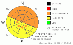
BOTTOM LINE
Danger by aspect and elevation on slopes approaching 35° or steeper.
(click HERE for tomorrow's danger rating)
|
Danger Rose Tutorial
|
The Bottom Line for today for the mountains of southeast Utah will be an Avalanche Danger of Considerable on steep, wind loaded slopes at and above tree line on NW through East aspects. Persistent weak layers will be a concern for shady aspects at and below tree line as well.
The Avalanche Danger may rise to High by Friday as the next storm system affects the area. The trend is for decreasing stability. Recreating in or beneath avalanche terrain is not advised for the next 72 hours. |
|
|
CURRENT CONDITIONS |

|
The weather pattern is continuing to bring consistent snow storms to the mountains of southeast Utah. 7" (17 cm) of snow fell at the Gold Basin study plot Monday night, bringing the total amount of snow on the ground to 52" (130 cm). There is 35" at the Geyser Pass Winter trail head and 42" down at Camp Jackson in the Abajo Mountains. San Juan County plowed the roads to all the access points on Tuesday. 4WD is still recommended.
The winds have been relentless at and above tree line in both the La Sal and Abajo Mountains. Strong winds out of the south - southwest for the past 24 hours with averages between 15-34 mph will be actively transporting and depositing snow onto leeward sides of slopes and ridges.
LUNA has not been able to groom the track since the last storm and may be able to groom after this next shot of snow. The best bet for winter recreation for the next couple of days will be low angled, wind sheltered meadows and glades. |
|
|
RECENT ACTIVITY |

|
There has been some activity lately to report in the La Sal Mountains. Natural avalanche activity occurred during last weekends wind event which produced climax avalanches to the ground. There were reports of some small human triggered avalanches below tree line on steep northerly facing glades. There are weaknesses out there and spring skiing conditions at least a couple weeks off. |
|
|
THREAT #1 |

|
| WHERE |
PROBABILITY |
SIZE |
TREND |
|
|
|
|
| |
|
|
Over the next
48 hours.
|
|
|
High relative humidity values and strong winds are transporting available snow and keeping it local. Expect sensitive wind slabs at and above tree line, in some places cross loaded, today and as the next storm progresses. |
|
|
THREAT #2 |

|
| WHERE |
PROBABILITY |
SIZE |
TREND |
|
|
|
|
| |
|
|
Over the next
24
hours.
|
|
|
OK folks, face it. We have a poor structure on shady aspects in the mountains of southeast Utah. There is no denying this fact. With more stress, these layers may become more reactive, especially in below tree line locations where snow depths are still on the shallow side and a humans weight can affect it. |
|
|
MOUNTAIN WEATHER |

|
@ 10,000' in La Sal Mountains, Utah
Today: Snow showers. High near 27. Breezy, with a west northwest wind between 10 and 20 mph. Chance of precipitation is 90%. Total daytime snow accumulation of 3 to 7 inches possible.
Tonight: Snow showers. Low around 7. Wind chill values as low as -10. Northwest wind between 10 and 15 mph. Chance of precipitation is 100%. New snow accumulation of 3 to 7 inches possible.
Friday: Snow, mainly before 4pm. High near 21. Wind chill values as low as -10. Blustery, with a north northwest wind around 20 mph. Chance of precipitation is 90%. New snow accumulation of 1 to 3 inches possible.
Friday Night: A 20 percent chance of snow before 11pm. Partly cloudy, with a low around 7. Northwest wind between 10 and 15 mph.
Saturday: Sunny, with a high near 32. North northwest wind between 5 and 15 mph. |
|
|
This information does not apply to developed ski areas or highways where avalanche control is normally done. This advisory is from the U.S.D.A. Forest Service, which is solely responsible for its content. This advisory describes general avalanche conditions and local variations always occur. |
|
This advisory provided by the USDA Forest Service, in partnership with:
The Friends of the Utah Avalanche Center, Utah Division of State Parks and Recreation, Utah Division of Emergency Management, Salt Lake County, Salt Lake Unified Fire Authority and the friends of the La Sal Avalanche Center. See our Sponsors Page for a complete list. |
