Moab Avalanche Advisory

Forecaster: Max Forgensi

BOTTOM LINE

Danger by aspect and elevation on slopes approaching 35° or steeper.
(click HERE for tomorrow's danger rating)


Danger Rose Tutorial

The Bottom Line for today for the mountains of southeast Utah will be an Avalanche Danger of Moderate on steep slopes greater than 35 degrees for persistent weak layers and wind slabs. The Avalanche Danger will increase to Considerable if the expected storm accumulations materialize.


CURRENT CONDITIONS

The Valentine's Day wind storm and the warm weather that followed left heavy powder conditions and thin sun crusts on sunny aspects. Snow coverage for the La Sal ans Abajo mountain ranges are still in the shallow category, hovering around one meter and basal weaknesses are still present can be triggered by a back country enthusiasts weight.

President's Weekend started off sunny on Saturday, and today is a storm day. Keep your fingers crossed that the wind stops blowing once the meat of the storm off to our west arrives.


RECENT ACTIVITY

None to report.


THREAT #1

WHERE PROBABILITY SIZE TREND
      Over the next 24 hours.

Persistent weak layers will be the biggest concern in the mountains, where over half of the snow pack still consists of faceted depth hoar grains. A myriad of crusts and wind slabs overlay this basal layer.


MOUNTAIN WEATHER

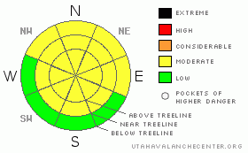
@ 10,000' in the La Sal Mountains

Today: Snow showers. High near 28. Breezy, with a south wind 15 to 25 mph becoming west. Winds could gust as high as 40 mph. Chance of precipitation is 90%. Total daytime snow accumulation of 3 to 5 inches possible.

Tonight: Snow showers, mainly before 4am. Low around 4. West northwest wind between 5 and 15 mph. Chance of precipitation is 80%. New snow accumulation of 3 to 5 inches possible.

Washington's Birthday: A 40 percent chance of snow showers, mainly before 8am. Partly sunny, with a high near 23. West wind between 5 and 15 mph.

Monday Night: Mostly cloudy, with a low around 7. Southeast wind around 5 mph becoming southwest.

Tuesday: Partly sunny, with a high near 30. Calm wind becoming west northwest between 10 and 15 mph.


This information does not apply to developed ski areas or highways where avalanche control is normally done.  This advisory is from the U.S.D.A. Forest Service, which is solely responsible for its content. This advisory describes general avalanche conditions and local variations always occur.


This advisory provided by the USDA Forest Service, in partnership with:

The Friends of the Utah Avalanche Center, Utah Division of State Parks and Recreation, Utah Division of Emergency Management, Salt Lake County, Salt Lake Unified Fire Authority and the friends of the La Sal Avalanche Center. See our Sponsors Page for a complete list.