SPECIAL ANNOUNCEMENT |
 |
LUNA volunteer extraordinaire Matt Hebberd from Rim Tours has put the finishing touches on the entire Nordic System as of 2:00 pm Wednesday afternoon. Everyone should thank Matt for his efforts putting down the finest corduroy for over a 200 mile radius. Thanks Matt.
Also, 2" of snow has fallen in the past 24 hours at the Gold Basin stake. Powder! |
|
|
BOTTOM LINE
Danger by aspect and elevation on slopes approaching 35° or steeper.
(click HERE for tomorrow's danger rating)
|
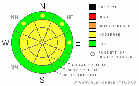
Danger Rose Tutorial
|
The Bottom Line for today will be an Avalanche Danger of Moderate on slopes greater than 35 degrees on top and cross loaded slopes at and above tree line. |
|
|
CURRENT CONDITIONS |

|
The expected storm system did not materialize and we only received 1" instead of the 10"-20" that was forecasted. The Avalanche Warning was cancelled this morning.
What we did receive is plenty of winds, scouring our once beloved powder conditions at and above tree line and creating hard slab conditions on leeward sides of slopes and ridges. Heavy powder conditions will be on tap even in wind sheltered locations, with better snow conditions down lower in elevation.
The road to all trail heads are in good shape. 2WD will be sufficient today. |
|
|
RECENT ACTIVITY |

|
Red Snow Cirque had some cornice buildup and failures during Tuesday nights wind event. There should be some other locations that wind loaded slopes failed. |
|
|
THREAT #1 |

|
| WHERE |
PROBABILITY |
SIZE |
TREND |
|
|
|
|
| |
|
|
Over the next
24 hours.
|
|
|
The winds have top loaded and cross loaded many aspects and elevations at and above tree line. With the lack of any winds, the natural avalanche cycle has ended and has left tender wind slabs in the starting zones and track of numerous avalanche paths. |
|
|
MOUNTAIN WEATHER |

|
@ 10,000' in the La Sal Mountains, Utah Today: Scattered snow showers. Mostly cloudy, with a high near 31. Southwest wind between 5 and 10 mph. Chance of precipitation is 40%. Tonight: A 30 percent chance of snow, mainly before 11pm. Mostly cloudy, with a low around 18. South wind around 5 mph becoming east. Thursday: Mostly sunny, with a high near 34. East wind around 5 mph becoming south. Thursday Night: Mostly clear, with a low around 18. South southeast wind 5 to 10 mph becoming north. Friday: Sunny, with a high near 36. North wind between 5 and 10 mph. Friday Night: Mostly clear, with a low around 20. Saturday: Sunny, with a high near 36. |
|
|
This information does not apply to developed ski areas or highways where avalanche control is normally done. This advisory is from the U.S.D.A. Forest Service, which is solely responsible for its content. This advisory describes general avalanche conditions and local variations always occur. |
|
This advisory provided by the USDA Forest Service, in partnership with:
The Friends of the Utah Avalanche Center, Utah Division of State Parks and Recreation, Utah Division of Emergency Management, Salt Lake County, Salt Lake Unified Fire Authority and the friends of the La Sal Avalanche Center. See our Sponsors Page for a complete list. |
