AVALANCHE WARNING »
Dangerous avalanche conditions are occuring or are imminent.
Backcountry travel in avalanche terrain is not recommended.
|
 |
Notice: An Avalanche Warning has been issued for the La Sal and Abajo Mountains of southeast Utah from Tuesday, February 14th through Wednesday, February 15th for heavy snow accumulations on top of persistent weak layers. Deep slab and storm snow instabilities will increase the Avalanche Danger to High.
Travel in or underneath avalanche terrain is not advised for the next 48 hours. Stay on slopes less than 32 degrees. |
|
|
BOTTOM LINE
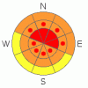
Danger by aspect and elevation on slopes approaching 35° or steeper.
(click HERE for tomorrow's danger rating)
|

Danger Rose Tutorial
|
The Bottom Line for Tuesday will be an Avalanche Danger of High at and above tree line on steep slopes greater than 32 degrees. Avalanche terrain should be avoided, and winter pursuits limited to lower angled slopes and meadows.
|
|
|
CURRENT CONDITIONS |

|
The first shot of storm brought 5" (12 cm) to the Gold Basin study plot bringing the total height of the snow on the ground to 46" (115 cm).
San Juan County plowed the road to the trail heads on Monday. 4WD will be necessary Tuesday and Wednesday due to the new snow accumulations.
Powder conditions reign in the mountains currently. There are plenty of safe areas to enjoy the snow without putting yourself in danger of avalanches. |
|
|
RECENT ACTIVITY |

|
Our observations today yielded only one observation of an avalanche in Red Snow Cirque on a SE aspect. Our neighbors in Colorado had numerous large slab avalanches affect the Red Mountain/Molas/Coal Bank passes. The only difference between our instabilities and theirs is about an inch of water weight, and we are expecting that amount in the next 36 hours in our mountains. Avalanche Dragons are hatching. |
|
|
THREAT #1 |

|
| WHERE |
PROBABILITY |
SIZE |
TREND |
|
|
|
|
| |
|
|
Over the next
48 hours.
|
|
|
Cross loading at and above tree line, as well as top loading will be a concern. The past, current and expected wind values have been and potentially will be below critical threshold values to create "wind slabs", yet still strong enough transport storm snow onto leeward sides of slopes and ridges.
New snow instabilities will be our first concern, with the potential for avalanches to step down in to persistent weak layers once enough snow is entrained. |
|
|
MOUNTAIN WEATHER |

|
@ 10,000' in Gold Basin, La Sal Mountains Utah.
Tuesday: Snow. High near 27. South southeast wind 5 to 10 mph becoming west. Chance of precipitation is 90%. New snow accumulation of 3 to 7 inches possible.
Tuesday Night: Snow likely. Cloudy, with a low around 15. North northwest wind 10 to 15 mph becoming west southwest. Chance of precipitation is 70%. New snow accumulation of 3 to 5 inches possible.
Wednesday: A 50 percent chance of snow showers. Mostly cloudy, with a high near 27. Southeast wind 10 to 15 mph becoming west. New snow accumulation of less than one inch possible.
Wednesday Night: A 30 percent chance of snow. Mostly cloudy, with a low around 12. North northwest wind between 10 and 15 mph. |
|
|
This information does not apply to developed ski areas or highways where avalanche control is normally done. This advisory is from the U.S.D.A. Forest Service, which is solely responsible for its content. This advisory describes general avalanche conditions and local variations always occur. |
|
This advisory provided by the USDA Forest Service, in partnership with:
The Friends of the Utah Avalanche Center, Utah Division of State Parks and Recreation, Utah Division of Emergency Management, Salt Lake County, Salt Lake Unified Fire Authority and the friends of the La Sal Avalanche Center. See our Sponsors Page for a complete list. |
