SPECIAL ANNOUNCEMENT |
 |
The following link is to an avalanche fatality that occurred over near Richfield, Utah this past weekend.
I believe anyone thinking about entering avalanche terrain should look at this LINK. The report highlights a few human factors that may have contributed to the accident AND a stark realization that the snow pack is not very much different than what we have in southeast Utah. Our condolences go out to the victim's family and friends.
I hope that this "lessons learned" may assist with keeping countless other back country enthusiasts on top of the best snow on earth. |
|
|
BOTTOM LINE
Danger by aspect and elevation on slopes approaching 35° or steeper.
(click HERE for tomorrow's danger rating)
|
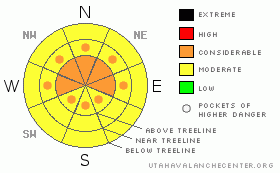
Danger Rose Tutorial
|
The Bottom Line for today in the La Sal and Abajo Mountain Ranges of southeast Utah will be an avalanche danger of Considerable at and above tree line on slopes greater than 35 degrees. Human triggered avalanches will be probable on slopes due to persistent weak layers under wind affected snow.
It is imperative for everyone to understand how widespread the weak structure exists. There is plenty of great skiing out there, enjoy it conservatively. |
|
|
CURRENT CONDITIONS |

|
Small storm systems continue to affect southeast Utah. 2" (5 cm) of snow fell in the last 24 hours at the Gold Basin study plot. It is 17 degrees at the Geyser Pass TH this morning with 30"on the ground while on Pre-Laurel Peak the temperature is 9 F. The Abajo mountains are warmer this morning; Camp Jackson is already at 30 degrees and has 34" on the ground.
The winds kicked up in both ranges out of the WSW-West for 10 hours with transport winds with values between 15 and 20 mph. These wind values will transport snow.
There is some great skiing conditions in the mountains right now. North and east aspects hold creamy powder while south and west aspects hold heavier snow up high and manageable crusts (~ 2 cm thick) in most areas.
Geyser Pass road is accessible to 4WD vehicles and LUNA volunteers are scheduled to groom the track again on Friday. |
|
|
RECENT ACTIVITY |

|
Yesterday's tour yielded some natural avalanche activity to report and widespread cracking and collapsing, some of which put butterflies into my stomach. Our OBSERVATION verified similar snow pack characteristics are widespread not only throughout the range, but throughout the state from other reports, such as Brett Kobernick's report from the Skyline a couple of days ago. WOW. Similar conditions have been found in Gold Basin. Click HERE to observe similarities in the two observations in the La Sal's, separated by over 5 miles.
TAKEALOOKATTHESELINKS!!!! THEVIDEOSTELLATALEthat I CANNOT express in words. Thanks Brett and Trent for exaggerating the size of tests to highlight the danger we face. |
|
|
THREAT #1 |

|
| WHERE |
PROBABILITY |
SIZE |
TREND |
|
|
|
|
| |
|
|
Over the next
48 hours.
|
|
|
There are a few persistent slabs and weak layers buried under the snow on different aspects and elevations. 1st off, over half of the snow pack (65 cm of 115 cm) at the Gold Basin study plot consists of mature facets with stronger, harder (slab) snow layers on top. You can easily transfer this structure to any shady aspect, as we found up near Mann's Peak yesterday. The snowpack is still shallow enough for a back country enthusiast to trigger this weak faceted basal layer.
The widespread crust we are finding on every aspect in the La Sal's that preceded last week's storm will also be a concern once buried deeper in the snow pack. Faceting is occurring above the crust layer and shovel burp tests are yielding quick, sudden planar shears. Once this layer interface is buried under a slab, it may give us yet another persistent weak layer to track and respect.
|
|
|
MOUNTAIN WEATHER |

|
@ 10,000' in Gold Basin, La Sal Mountains, Utah.
Today: A 50 percent chance of snow, mainly before 11am. Partly sunny, with a high near 31. North northwest wind between 10 and 15 mph, with gusts as high as 25 mph. Total daytime snow accumulation of less than a half inch possible.
Tonight: Partly cloudy, with a low around 18. Northeast wind between 5 and 10 mph, with gusts as high as 20 mph.
Friday: Sunny, with a high near 37. Calm wind becoming west between 5 and 10 mph. Winds could gust as high as 20 mph.
Friday Night: Mostly clear, with a low around 22. East southeast wind around 5 mph becoming calm.
Saturday: A 20 percent chance of snow. Partly sunny, with a high near 36. East southeast wind around 5 mph becoming south southwest. |
|
|
This information does not apply to developed ski areas or highways where avalanche control is normally done. This advisory is from the U.S.D.A. Forest Service, which is solely responsible for its content. This advisory describes general avalanche conditions and local variations always occur. |
|
This advisory provided by the USDA Forest Service, in partnership with:
The Friends of the Utah Avalanche Center, Utah Division of State Parks and Recreation, Utah Division of Emergency Management, Salt Lake County, Salt Lake Unified Fire Authority and the friends of the La Sal Avalanche Center. See our Sponsors Page for a complete list. |
