SPECIAL ANNOUNCEMENT |
 |
The following link is to an avalanche fatality that occurred over near Richfield, Utah this past weekend.
I believe anyone thinking about entering avalanche terrain should look at this LINK. The report highlights a few human factors that may have contributed to the accident AND a stark realization that the snow pack is not very much different than what we have in southeast Utah. Our condolences go out to the victim's family and friends.
I hope that this "lessons learned" may assist with keeping countless other back country enthusiasts on top of the best snow on earth. |
|
|
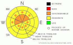
BOTTOM LINE
Danger by aspect and elevation on slopes approaching 35° or steeper.
(click HERE for tomorrow's danger rating)
|
Danger Rose Tutorial
|
The Bottom Line for today in the La Sal and Abajo Mountain Ranges of southeast Utah will be an avalanche danger of Considerable at and above tree line on slopes greater than 35 degrees. Human triggered avalanches will be probable on slopes due to persistent weak layers under wind affected snow.
There is great skiing and riding conditions, the best of the season. ENJOYthe bounty from our five day storm, but keep those objectives in high risk avalanche terrain for later in the season. Close up shop and enjoy a fine powder day. |
|
|
CURRENT CONDITIONS |

|
The storm of the past 5 days has finally moved out, leaving blue skies and a total of around 10" for both the La Sal and Abajo Mountain ranges. The storm quietly exited, winds have been light and variable for the past 24 hours leaving great powder conditions.
San Juan County will be up to plow the road to the Geyser Pass Parking Lot on Tuesday, and the corduroy will be groomed into Gold Basin and around the Meadow Loop by 11:00 am.
Some of the best powder conditions exist up in the La Sal Mountain range of the year. Human factors such as "Blue Sky Syndrome" or "Goal Orientation" will have to be in check. Stay on lower angled terrain (below 32 degrees), and work into avalanche terrain conservatively. Our snow pack is complex with numerous slabs and weak layering, continue with the forecast for more information. |
|
|
RECENT ACTIVITY |

|
We haven't had visibility lately to observe natural avalanches. Click HEREfor an observation/video of what our current snow pack looks like. |
|
|
THREAT #1 |

|
| WHERE |
PROBABILITY |
SIZE |
TREND |

|
|
|
|
| |
|
|
Over the next
48 hours.
|
|
|
There are a few persistent slabs and weak layers buried under the snow on different aspects and elevations. 1st off, over half of the snow pack (65 cm of 115 cm) at the Gold Basin study plot consists of mature facets with stronger, harder (slab) snow layers on top. You can easily transfer this structure to any shady aspect. The snowpack is still shallow enough for a back country enthusiast to trigger this weak faceted basal layer.
During the 1st round of the 5 day storm, winds were actively loading southerly aspects with a hard wind slab. These slabs have had time to heal, yet there will be places high in the alpine that slabs on southerly aspects formed on steep slopes and difficult to detect trigger points due to cross loading.
Finally, on Saturday and Sunday (2/4-2/5) we received two separate wind events from the south east. The events lasted 9 hours and 6 hours respectively and mainly affected above tree line locations. Regardless, there was plenty of snow to transport onto Northerly aspects...a natural avalanche cycle may have occurred mid storm on these aspects, and there will be plenty of avalanche dragons waiting to be hatched. |
|
|
MOUNTAIN WEATHER |

|
@ 10,000' in Gold Basin, La Sal Mountains Today: Sunny, with a high near 32. East wind 5 to 10 mph becoming south southwest. Tonight: Partly cloudy, with a low around 16. Southwest wind around 15 mph. Wednesday: A 20 percent chance of snow showers after 11am. Partly sunny, with a high near 40. West southwest wind between 10 and 15 mph. Wednesday Night: A 40 percent chance of snow showers. Mostly cloudy, with a low around 20. West northwest wind around 10 mph. Thursday: A 30 percent chance of snow. Mostly sunny, with a high near 33. Breezy, with a north northwest wind 5 to 10 mph increasing to between 20 and 25 mph. Winds could gust as high as 35 mph. |
|
|
This information does not apply to developed ski areas or highways where avalanche control is normally done. This advisory is from the U.S.D.A. Forest Service, which is solely responsible for its content. This advisory describes general avalanche conditions and local variations always occur. |
|
This advisory provided by the USDA Forest Service, in partnership with:
The Friends of the Utah Avalanche Center, Utah Division of State Parks and Recreation, Utah Division of Emergency Management, Salt Lake County, Salt Lake Unified Fire Authority and the friends of the La Sal Avalanche Center. See our Sponsors Page for a complete list. |
