BOTTOM LINE
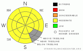
Danger by aspect and elevation on slopes approaching 35° or steeper.
(click HERE for tomorrow's danger rating)
|
Danger Rose Tutorial
|
The bottom line for Tuesday will be an avalanche danger of moderate on steep slopes greater than 35 degrees in the La Sal and Abajo mountain ranges. Be careful around trigger points such as convex rollovers, trim lines and exposed rocks.
This advisory will be updated Friday morning. |
|
|
CURRENT CONDITIONS |

|
Reports of good skiing conditions are filtering in from the mountains. Sheltered below tree-line skiing seems to be the best bet, while upper elevation sunny aspects are challenging to navigate due to snow conditions.
LUNA volunteers went up on Monday and groomed the Meadow and Gold Basin tracks and up to Geyser Pass. Expect the upper Loppet loops to be marked and groomed by Friday afternoon. Thanks Kristi and Jesse!
High temperatures at the Geyser Pass trail head reached 37 degrees yesterday, while Camp Jackson hovered at 39 for close to 5 hours. Sunny aspects will be sun crusted today. |
|
|
RECENT ACTIVITY |

|
There is nothing new to report. Natural avalanche activity from the last storm was limited to NE-N aspects at and below tree-line. |
|
|
THREAT #1 |

|
| WHERE |
PROBABILITY |
SIZE |
TREND |

|
|
|
|
| |
|
|
Over the next
24 hours.
|
|
|
As we move farther away from the last storm, formerly sensitive cross-loaded and top-loaded wind slabs and new snow soft slabs shuffle into the persistent slab category. Our laccolith mountains of southeast Utah are built with moderate slopes up high, only to roll over a convexity half way or two-thirds of the way down a slope. These locations will be the most dangerous for a back country traveler. Mitigating the human factor in avalanche terrain will be the most difficult challenge. Risk vs. Reward. The level of commitment to a slope. Have numerous alternative objectives on tours and remember, you can always back off. Tomorrow is another day! |
|
|
THREAT #2 |

|
| WHERE |
PROBABILITY |
SIZE |
TREND |

|
|
|
|
| |
|
|
Over the next
24 hours.
|
|
|
With high clouds burning off, the sun and temperature will affect sunny slopes today. Expect loose snow avalanches on steep slopes with good alignment to the sun. |
|
|
MOUNTAIN WEATHER |

|
@ 10,000' in the La Sal Mountains, Utah
Today: Partly sunny, with a high near 37. North wind around 5 mph.
Tonight: Mostly cloudy, with a low around 22. Calm wind becoming southeast around 5 mph.
Wednesday: Mostly sunny, with a high near 37. South wind between 5 and 10 mph, with gusts as high as 25 mph.
Wednesday Night: A 50 percent chance of snow, mainly after 11pm. Mostly cloudy, with a low around 23. South southwest wind around 15 mph, with gusts as high as 30 mph. New snow accumulation of less than one inch possible.
Thursday: Snow likely, mainly after 11am. Cloudy, with a high near 29. Windy, with a west southwest wind 15 to 20 mph becoming northwest between 30 and 35 mph. Chance of precipitation is 60%.
Thursday Night: A 40 percent chance of snow. Mostly cloudy, with a low around 14.
Friday: A 20 percent chance of snow. Mostly sunny, with a high near 28. |
|
|
This information does not apply to developed ski areas or highways where avalanche control is normally done. This advisory is from the U.S.D.A. Forest Service, which is solely responsible for its content. This advisory describes general avalanche conditions and local variations always occur. |
|
This advisory provided by the USDA Forest Service, in partnership with:
The Friends of the Utah Avalanche Center, Utah Division of State Parks and Recreation, Utah Division of Emergency Management, Salt Lake County, Salt Lake Unified Fire Authority and the friends of the La Sal Avalanche Center. See our Sponsors Page for a complete list. |
