BOTTOM LINE
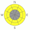
Danger by aspect and elevation on slopes approaching 35° or steeper.
(click HERE for tomorrow's danger rating)
|
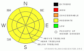
Danger Rose Tutorial
|
The Bottom Line for today will be an avalanche danger of Moderate on steep slopes greater than 35 degrees in the La Sal and Abajo mountain ranges. Remember, a Moderate avalanche danger means that human triggered avalanche are still Possible.
A poorly structured snow pack containing a lot of energy rests in many starting zones. Look and listen for Mother Nature's clues of instability! |
|
|
CURRENT CONDITIONS |

|
Winter sport is alive in southeast, Utah! LUNA volunteers Mark Weissinger and Ed Oak went up and groomed the Meadow Loop, Gold Basin track and up to Geyser Pass yesterday. The corduroy looks sweet.
All roads to our winter trail heads are plowed, most 2WD vehicles will make it this weekend.
The current northwest flow has been limiting daytime high temperatures to the low 30's. Superb skiing conditions will be found on sheltered north and northeast aspects, while west and south aspects will have different sun crust conditions, dependent on the orientation of the slope angle to the noon day sun. Gold Basin has 40" of snow on the ground (100 cm), which is the low end of covering ground hazards in most areas. Be careful as you descend, the conditions will change from supportable to trap door.
|
|
|
RECENT ACTIVITY |

|
None of our observers have seen any large natural avalanches, yet they all remark on how many and how large whoomps and settlements travel. Mother Nature is still giving us warning signs, just not the "in your face" kind. |
|
|
THREAT #1 |

|
| WHERE |
PROBABILITY |
SIZE |
TREND |

|
|
|
|
| |
|
|
Over the next
48 hours.
|
|
|
Wind slabs have formed on almost all aspects and elevations. Cross loading is the biggest concern. These slabs of wind transported snow are tricky to detect and a back country enthusiast can go from no hazard (on rocks) to an avalanche prone slope in just one step.
On our tour down to the Abajos on Thursday, skiing wind slab conditions on a ridge was very variable, each turn had its own characteristic and if we were in avalanche terrain, our stress would have most definitely triggered an avalanche. |
|
|
THREAT #2 |

|
| WHERE |
PROBABILITY |
SIZE |
TREND |
|
|
|
|
| |
|
|
Over the next
48 hours.
|
|
|
In locations where the wind has not surfaced, the new snow from the past seven days rests on a very weak, shallow snow pack. Be careful on steep slopes below tree line, especially near trigger points such as the bottom of a treed slope, or unanchored slopes.
|
|
|
MOUNTAIN WEATHER |

|
@ 10,000' in Gold Basin, La Sal Mountains Utah
Today: Sunny, with a high near 34. North wind around 5 mph.
Tonight: Mostly clear, with a low around 19. East wind around 5 mph.
Sunday: Sunny, with a high near 38. East wind around 5 mph becoming calm.
Sunday Night: Mostly clear, with a low around 21. South southeast wind around 5 mph, with gusts as high as 20 mph.
Monday: Mostly sunny, with a high near 37. South southwest wind between 10 and 15 mph.
Monday Night: Mostly cloudy, with a low around 20.
Tuesday: A 20 percent chance of snow. Partly sunny, with a high near 31. |
|
|
This information does not apply to developed ski areas or highways where avalanche control is normally done. This advisory is from the U.S.D.A. Forest Service, which is solely responsible for its content. This advisory describes general avalanche conditions and local variations always occur. |
|
This advisory provided by the USDA Forest Service, in partnership with:
The Friends of the Utah Avalanche Center, Utah Division of State Parks and Recreation, Utah Division of Emergency Management, Salt Lake County, Salt Lake Unified Fire Authority and the friends of the La Sal Avalanche Center. See our Sponsors Page for a complete list. |
