SPECIAL ANNOUNCEMENT |
 |
UPDATE: Wednesday, January 25th 2012 @ 1730.
Click here to see an observation from today's tour. Please utilize this information.
The road to the Geyser Pass TH was plowed today. San Juan County Road Department is ONIT and we all thank you.
I will be updating this forecast tomorrow morning. |
|
|
BOTTOM LINE
Danger by aspect and elevation on slopes approaching 35° or steeper.
(click HERE for tomorrow's danger rating)
|
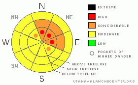
Danger Rose Tutorial
|
The BOTTOMLINEfor today will be an avalanche danger of CONSIDERABLEwith areas of HIGH at and above treeline on slopes greater than 32 degrees on north-northeast-east aspects.
There is great skiing conditions in lower angled meadows and sheltered trees from 11,300- to 10,300'. Stay away from avalanche paths today. Do not travel beneath avalanche paths as well. |
|
|
CURRENT CONDITIONS |

|
Saturday's storm brought the avalanche conditions to a precarious balancing point. On Sunday's tour, we observed that storm snow started off relatively warm and windy and ended cold and fluffy. The end result was that there was not a widespread avalanche cycle yet, but the snow reactive to a skiers weight. Lots of whoomphing and shooting cracks, and a few human triggered avalanches on test slopes and road cuts. Click here to view a good observation from a back country observer in the La Sals.
With another storm bearing down on southeast Utah today, the low density powder snow deposited at the end of Saturday's storm is available for transport. Winds have been strong out of the south through southwest on both Abajo and Pre-Laurel Peaks, averaging 18-24 mph. These winds will be creating conditions for a delayed avalanche cycle in our mountain range.
San Juan County have their hands full. 4WD is needed to get to the Geyser Pass trailhead. LUNA grooming will be on hold until the round of storms passes. |
|
|
RECENT ACTIVITY |

|
See the observation above to for a picture of one of the small avalanches. |
|
|
THREAT #1 |

|
| WHERE |
PROBABILITY |
SIZE |
TREND |
|
|
|
|
| |
|
|
Over the next
48 hours.
|
|
|
Available snow for transport and transport winds have created top loaded and cross loaded slopes. These wind slabs will be reactive to a skiers weight and may be triggered from low angled ridge lines. The potential for avalanche activity will only increase as today's storm gets established.
The snow pack is relatively weak, the structure in starting zones supports an avalanche cycle and there is lots of potential energy. Just a little more stress and avalanches will run. |
|
|
THREAT #2 |

|
| WHERE |
PROBABILITY |
SIZE |
TREND |

|
|
|
|
| |
|
|
Over the next
48 hours.
|
|
|
The majority of the mountains of southeast Utah did not have very good coverage, if any, before the last storm. As the snow pack becomes more layered, especially rapidly, there are more interfaces that may not bond well. Be aware of steep gullies or small slopes that may be reactive to a skiers or snowmobiles weight. |
|
|
MOUNTAIN WEATHER |

|
@ 10,000' in Gold Basin, La Sal Mountains Utah Today: A 40 percent chance of snow. Cloudy, with a high near 33. South wind between 10 and 15 mph. Tonight: Snow. Low around 20. South wind 5 to 15 mph becoming northwest. Chance of precipitation is 100%. New snow accumulation of 3 to 5 inches possible. Tuesday: Snow likely. Cloudy, then gradually becoming mostly sunny, with a high near 30. North northwest wind between 5 and 10 mph. Chance of precipitation is 70%. New snow accumulation of 1 to 2 inches possible. Tuesday Night: Partly cloudy, with a low around 21. North northeast wind between 5 and 10 mph. Wednesday: Sunny, with a high near 38. North northwest wind between 10 and 15 mph. |
|
|
This information does not apply to developed ski areas or highways where avalanche control is normally done. This advisory is from the U.S.D.A. Forest Service, which is solely responsible for its content. This advisory describes general avalanche conditions and local variations always occur. |
|
This advisory provided by the USDA Forest Service, in partnership with:
The Friends of the Utah Avalanche Center, Utah Division of State Parks and Recreation, Utah Division of Emergency Management, Salt Lake County, Salt Lake Unified Fire Authority and the friends of the La Sal Avalanche Center. See our Sponsors Page for a complete list. |
