AVALANCHE WARNING »
Dangerous avalanche conditions are occuring or are imminent.
Backcountry travel in avalanche terrain is not recommended.
|
 |
Notice: The La Sal and Abajo Mountains are under an Avalanche Warning from Sunday, January 22nd at 7:30 am to Monday January 23rd at 7:30 am. Over a foot of snow has accumulated on a very weak snow pack. Combined with strong transport winds, large natural avalanches will occur on North through Southeast aspects at and above treeline. Back country travel in or under avalanche terrain is not advised. |
|
|
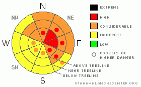
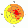
BOTTOM LINE
Danger by aspect and elevation on slopes approaching 35° or steeper.
(click HERE for tomorrow's danger rating)
|
Danger Rose Tutorial
|
The BOTTOMLINEfor today will be an Avalanche Danger of HIGH at and above tree line on steep slopes greater than 30 degrees on North through SE aspects. Travel into or under avalanche terrain is not advised for at least the next 24 hours. Stay instead to lower angled terrain or meadows. |
|
|
CURRENT CONDITIONS |

|
The storm of the last 24 hours has left between 7"-12" of snow on the ground and snow water equivalent values of 1.1"-1.6" of H20. Snow densities will change dependent on elevation, expect 15% snow density down low and 10% snow density up high. Unfortunately, the wind is still transporting snow from fetch areas and depositing storm snow on leeward sides of slopes and ridges. The winds averaged from 15-40 mph with gusts up to 60 mph in the past 24 hours, starting out of the southeast and veering to its current northwesterly wind direction. Storm snow may have been deposited much lower in the starting zones due to the strong winds.
We have numerous variables which is contributing to the certain natural avalanche cycle. Once again, back country travel is NOTADVISED into or under avalanche terrain today. I would not venture into North Creek in the Abajos or into Gold Basin proper for example, where natural avalanches can hit summer roads and trails. |
|
|
RECENT ACTIVITY |

|
It will be a spectacular avalanche cycle out there. Just do so from a safe vantages. |
|
|
THREAT #1 |

|
| WHERE |
PROBABILITY |
SIZE |
TREND |
|
|
|
|
| |
|
|
Over the next
24 hours.
|
|
|
A large cohesive blanket of transported storm snow lies on a very weak, faceted snow pack that will act as ball bearings. Back country travelers will hear and see whoomphs and shooting c racks from their skis and snowmobiles today. The possibility of triggering large avalanches from ridgelines is very possible. Some of these avalanches may pull back onto ridge lines, so be careful. |
|
|
MOUNTAIN WEATHER |

|
@ 10,000' in Gold Basin, La Sal Mountains Utah
Today: A 30 percent chance of snow, mainly after 11am. Partly sunny, with a high near 31. West northwest wind around 15 mph.
Tonight: A 20 percent chance of snow. Mostly cloudy, with a low around 12. South southeast wind between 5 and 10 mph.
Monday: A 50 percent chance of snow. Mostly cloudy, with a high near 30. South southeast wind between 10 and 15 mph. New snow accumulation of around an inch possible.
Monday Night: Snow. Low around 18. South wind around 10 mph becoming northwest. Chance of precipitation is 80%. New snow accumulation of 3 to 5 inches possible.
Tuesday: Snow likely. Cloudy, with a high near 31. North wind between 10 and 15 mph. Chance of precipitation is 60%.
Tuesday Night: Partly cloudy, with a low around 20.
Wednesday: Sunny, with a high near 39.
|
|
|
This information does not apply to developed ski areas or highways where avalanche control is normally done. This advisory is from the U.S.D.A. Forest Service, which is solely responsible for its content. This advisory describes general avalanche conditions and local variations always occur. |
|
This advisory provided by the USDA Forest Service, in partnership with:
The Friends of the Utah Avalanche Center, Utah Division of State Parks and Recreation, Utah Division of Emergency Management, Salt Lake County, Salt Lake Unified Fire Authority and the friends of the La Sal Avalanche Center. See our Sponsors Page for a complete list. |
