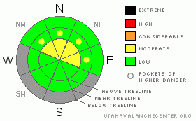
BOTTOM LINE
Danger by aspect and elevation on slopes approaching 35° or steeper.
(click HERE for tomorrow's danger rating)
|

Danger Rose Tutorial
|
The BOTTOM LINE for the the rest of Monday and Tuesday will be an Avalanche Danger of MODERATE on steep, wind loaded slopes on N-NE aspects at and above treeline. Strong winds and high RH values will keep any new snow available for transport locally. |
|
|
CURRENT CONDITIONS |

|
Well, I have been waiting to put this forecast out so I can give some good news to southeast Utah, but unfortunately the change in the weather pattern has given us all blow and no snow. Pre-Laurel Peak has been registering winds averaging from 18-34 mph out of the south for over 24 hours. A high cloud ceiling is a saturated as our air mass has achieved, with most of the moisture traveling to our south and east. Wolf Creek registered 7" this morning while Durango Mountain Resort 3", Red Mountain 4.5, Coal Bank Pass 8". If you are looking to ski downhill, fill up the gas tank and head out Moab. We currently sit between 60 and 75% of normal snow water equivalent in southeast Utah.
Both Camp Jackson (20") and the Geyser Pass TH (15") have registered 0.10" of H20 in the past 24 hours. Our next slight chance of snow is four more days out.
There is a silver lining to the dark, non-snow producing clouds over our mountains. LUNA has groomed the Gold Basin and Meadow Loops on the Martin Luther King Holiday. Thank the volunteers next time you see one! |
|
|
RECENT ACTIVITY |

|
NADA |
|
|
THREAT #1 |

|
| WHERE |
PROBABILITY |
SIZE |
TREND |

|
|
|
|
| |
|
|
Over the next
48 hours.
|
|
|
Strong wind, high RH values and snow equates to the formation of wind slabs. The more available snow there is for transport, the chance of adding stress to the snow pack increases. The amount of new snow is unfortunately not a concern. Strong winds and high RH values allow for existing snow grains to travel much longer distances from fetch areas and deposition into lower areas of starting zones. I expect there has been a deposition of some thin wind skins that are reactive to a skiers weight. |
|
|
MOUNTAIN WEATHER |

|
@ 10,000' in Gold Basin, La Sal Mountains, Utah
Tuesday: Sunny, with a high near 27. Southwest wind between 5 and 10 mph.
Tuesday Night: Partly cloudy, with a low around 15. South southwest wind between 10 and 15 mph. Wednesday: Partly sunny, with a high near 37. South southeast wind 10 to 15 mph becoming west southwest. Wednesday Night: Mostly cloudy and breezy, with a low around 24. Thursday: A 20 percent chance of snow. Partly sunny, with a high near 41. Thursday Night: A chance of snow. Mostly cloudy and breezy, with a low around 26. Friday: A slight chance of snow. Partly sunny, with a high near 41. |
|
|
GENERAL ANNOUNCEMENTS |
The Utah Avalanche Center in Moab will be hosting an AIARE Level I Avalanche Class from Friday February 3rd through Sunday February 5th....weather dependent. Please call 435.636.3335 for more information or to sign up. |
|
|
This information does not apply to developed ski areas or highways where avalanche control is normally done. This advisory is from the U.S.D.A. Forest Service, which is solely responsible for its content. This advisory describes general avalanche conditions and local variations always occur. |
|
This advisory provided by the USDA Forest Service, in partnership with:
The Friends of the Utah Avalanche Center, Utah Division of State Parks and Recreation, Utah Division of Emergency Management, Salt Lake County, Salt Lake Unified Fire Authority and the friends of the La Sal Avalanche Center. See our Sponsors Page for a complete list. |


