SPECIAL ANNOUNCEMENT |
 |
The Utah Avalanche Center in Moab will be hosting a free Basic Avalanche Awareness Talk at the Grand County Public Library at 6:00 pm TONIGHT. Everyone is invited! |
|
|
BOTTOM LINE
Danger by aspect and elevation on slopes approaching 35° or steeper.
(click HERE for tomorrow's danger rating)
|
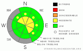
Danger Rose Tutorial
|
The BOTTOM LINE for today (and Saturday) will be an Avalanche Danger of MODERATE at and above tree-line on steep slopes greater than 35 degrees which hold wind slabs.
The impending storm will cover a myriad of ground hazards, albeit very lightly. Great care should be taken if traveling into the back country this weekend. |
|
|
CURRENT CONDITIONS |

|
There is a short, but hopeful, change in the weather pattern for southeast Utah this weekend. A shortwave deepens in the Great Basin on Saturday, bringing limited moisture from the northwest to the southeast. It appears that Saturday afternoon and Saturday night will be the best chance of precipitation. With this new snow in the forecast, it is time for everyone to think about the hatching of avalanche dragons in southeast Utah, especially on Sunday.
The winds have picked up on Abajo and Pre-Laurel Peak; consistent winds for the past 12 hours out of the WNW-NNW averaging 12-20 mph is an indicator of the first weak short wave. Temperatures on the ridgelines are hovering in the mid-20's this morning. The biggest surprise was the warm temperatures at Camp Jackson last night, where it did not freeze and current temperatures are close to 40 degrees F.
The Geyser Pass Trailhead has 15" (38 cm) of snow on the ground, while in Gold Basin there is 26" (65 cm) of snow at the historical study plot. Yesterday, the Gold Basin track was groomed and the sonic snow stake was replaced in Gold Basin. Thank you Ed Grote and Dan Judd for your timely help on this matter. Camp Jackson has 21" of snow on the ground.
The back country skiing is an adventure with numerous ground hazards currently. The best bet for today is to have fun skipping through meadows or staying on the groomed track. |
|
|
RECENT ACTIVITY |

|
No new recent activity to report. |
|
|
THREAT #1 |

|
| WHERE |
PROBABILITY |
SIZE |
TREND |

|
|
|
|
| |
|
|
Over the next
48 hours.
|
|
|
Yesterday's field day told an interesting tale for January 6th. Not only was it so hot at the trail head one could sun bathe comfortably, the benign early winter weather has taken its toll on sunny aspects. There are locations in the mountains on southerly and westerly aspects that are completely bare to 11,000', while on their northerly counterparts, a weak, completely faceted snow structure exists. Corn snow was forming on the road and it smelled like spring.
The expected storm may freshen conditions up a bit but also create an unstable snow structure and increase the energy contained within it. With new snow accumulations combined with wind, you can expect sensitive wind slabs to form on leeward slopes and ridges, and these slopes should be a concern. |
|
|
MOUNTAIN WEATHER |

|
@ 10,000' in the La Sal Mountains of Southeast Utah:
Today: Mostly sunny, with a high near 40. North northwest wind around 5 mph becoming west southwest.
Tonight: Partly cloudy, with a low around 22. South southwest wind between 5 and 10 mph.
Saturday: Snow likely, mainly after 11am. Mostly cloudy, with a high near 32. South wind 10 to 15 mph becoming west. Chance of precipitation is 70%. New snow accumulation of 1 to 3 inches possible.
Saturday Night: Snow. Low around 12. North northwest wind around 15 mph becoming south southwest. Chance of precipitation is 90%. New snow accumulation of 5 to 9 inches possible.
Sunday: A 20 percent chance of snow. Partly sunny, with a high near 31. Blustery, with a north wind 15 to 20 mph becoming south southwest.
Sunday Night: Mostly clear, with a low around 17.
Monday: Sunny, with a high near 39.
|
|
|
This information does not apply to developed ski areas or highways where avalanche control is normally done. This advisory is from the U.S.D.A. Forest Service, which is solely responsible for its content. This advisory describes general avalanche conditions and local variations always occur. |
|
This advisory provided by the USDA Forest Service, in partnership with:
The Friends of the Utah Avalanche Center, Utah Division of State Parks and Recreation, Utah Division of Emergency Management, Salt Lake County, Salt Lake Unified Fire Authority and the friends of the La Sal Avalanche Center. See our Sponsors Page for a complete list. |
