BOTTOM LINE
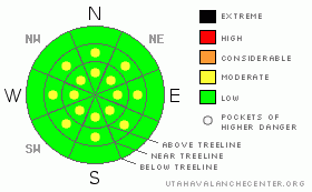
Danger by aspect and elevation on slopes approaching 35° or steeper.
(click HERE for tomorrow's danger rating)
|
Danger Rose Tutorial
|
The BOTTOM LINEfor today will be an avalanche danger of LOW in the La Sal and Abajo Mountain ranges with pockets of MODERATE at and above tree line on steep slopes greater than 35 degrees that hold reactive wind skins.
The biggest danger in the mountains is injury due to a consistent mine field of rocks, logs, tiger traps. Making turns is a bonus and should be done cautiously. |
|
|
CURRENT CONDITIONS |

|
San Juan County buffed out the Geyser Pass Road and the Gold Basin and Meadow Loops were groomed yesterday. Today will be a great day to climb a peak, cross country or skate ski, go sledding...2WD will get you to any of the parking lots.
What is missing in the "to do" list is: back country skiing. Yesterday, we went up looking to ski avalanche protected slopes. You can look at the field day HERE. It was very difficult to travel below 10,500', but we did find some turns just below tree line. I would suggest to skin up adjacent to your downhill escape route, practice survival skiing and watch out for tiger traps. Remember, any day in the mountains is better than one in the office!
There is 26" of snow in Gold Basin, 17" at the Geyser Pass Trailhead, 23" in the Abajo's at Camp Jackson. The winds are nuking on the ridge lines. I think I'm going to hit the tacky desert single track today. |
|
|
RECENT ACTIVITY |

|
There has been no recent activity and our snow pack is really starting to turn completely to facets. Crusts on sunny slopes are breaking down or just completely bare. Our snowpack is weak without much energy currently, the next storm will bring the house down again. |
|
|
THREAT #1 |

|
| WHERE |
PROBABILITY |
SIZE |
TREND |

|
|
|
|
| |
|
|
Over the next
24
hours.
|
|
|
Strong winds have transported a myriad of wind slab conditions into starting zones at and above tree line. These are more reactive immediately after deposition (24 hours or less). |
|
|
MOUNTAIN WEATHER |

|
@ 10,000' in Gold Basin, La Sal Mountains.
Today: Sunny, with a high near 41. South southeast wind 10 to 15 mph becoming north northwest. Tonight: Partly cloudy, with a low around 21. Blustery, with a northwest wind between 15 and 25 mph, with gusts as high as 40 mph. Thursday: Mostly sunny, with a high near 41. Breezy, with a north wind 15 to 25 mph becoming west. Winds could gust as high as 40 mph. Thursday Night: Mostly clear, with a low around 30. West wind around 15 mph becoming southeast. Friday: Sunny, with a high near 41. West wind around 5 mph. Friday Night: Mostly clear, with a low around 23. Saturday: Sunny, with a high near 40. |
|
|
GENERAL ANNOUNCEMENTS |
Join us for a Basic Avalanche Awareness Class at the Grand County Public Library on Friday, January 6th at 6:00 pm.
Looking for a Level I Class? Our annual 3 day AIARELevel I class will be held February 3rd through the 5th. Call 435-636-3335 for more details or to sign up. |
|
|
This information does not apply to developed ski areas or highways where avalanche control is normally done. This advisory is from the U.S.D.A. Forest Service, which is solely responsible for its content. This advisory describes general avalanche conditions and local variations always occur. |
|
This advisory provided by the USDA Forest Service, in partnership with:
The Friends of the Utah Avalanche Center, Utah Division of State Parks and Recreation, Utah Division of Emergency Management, Salt Lake County, Salt Lake Unified Fire Authority and the friends of the La Sal Avalanche Center. See our Sponsors Page for a complete list. |
