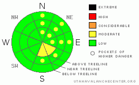
BOTTOM LINE
Danger by aspect and elevation on slopes approaching 35° or steeper.
(click HERE for tomorrow's danger rating)
|

Danger Rose Tutorial
|
The BOTTOMLINEfor today will be an avalanche danger of MODERATE on steep slopes greater than 35 degrees at and above treeline where shallow wind skins exist and in isolated locations on NW-N-NE-E aspects. The main concern today will be shallow coverage...ground hazards will be encountered on your ski tour today. |
|
|
CURRENT CONDITIONS |

|
At least two inches of new snow fell in the La Sals during Thursday's shot of moisture that brought snow to the Grand Valley. The Abajos received only a dusting of new snow out of the event. The difference is in the winds and relative humidity between the ranges. Strong winds out of the NE in the La Sal's with low RH's is allowing snow available to transport to sublimate into the atmosphere...where losing snow with minimal wind skin development in the La Sals. The Abajos have been receiving stronger and more constant winds out of the NW with a higher RH, which is depositing snow available to transport onto Southeast aspects along ridgelines.
There is some decent back country skiing conditions in both ranges currently with the primary objectives of staying safe and having fun. Sheltered shady slopes will be the best bet for turns. Today will be the last day to make turns on West and South aspects, until we get more snow or the condition turns to mid-winter corn.
LUNA went up and groomed into Gold Basin around the meadow loop yesterday. Nordic or skate skiing will be a great idea for those to enjoy Christmas Eve in the mountains. The two inches of snow that did fall does not really warrant San Juan County to plow. The road is in good shape, although icy patches have formed. 4WD is recommended. |
|
|
RECENT ACTIVITY |

|
No new avalanche activity to report. Thursdays storm and current winds have not increased the loading enough to initiate a natural avalanche cycle. |
|
|
THREAT #1 |

|
| WHERE |
PROBABILITY |
SIZE |
TREND |

|
|
|
|
| |
|
|
Over the next
24 hours.
|
|
|
Thin wind skins will hold enough energy to initiate and propagate avalanches in deposition areas. These wind skins will be located along ridge lines. |
|
|
THREAT #2 |

|
| WHERE |
PROBABILITY |
SIZE |
TREND |

|
|
|
|
| |
|
|
Over the next
24 hours.
|
|
|
Cold shallow snow is dominating our North-NE-East slopes. These locations should be approached with caution, especially in locations containing trigger points such as: convex rollovers or buried rocks and logs. A back country enthusiast in these locations will also have to navigate through plenty of ground hazard. |
|
|
MOUNTAIN WEATHER |

|
@ 10,000' in the La Sal Mountains.
Today: Sunny, with a high near 34. North northeast wind around 5 mph.
Tonight: Mostly clear, with a low around 12. Northeast wind around 5 mph.
Christmas Day: Sunny, with a high near 38. North northwest wind around 5 mph.
Sunday Night: Mostly clear, with a low around 18. Calm wind.
Monday: Sunny, with a high near 38. North northeast wind around 5 mph.
Monday Night: Mostly clear, with a low around 17.
Tuesday: Mostly sunny, with a high near 33. |
|
|
This information does not apply to developed ski areas or highways where avalanche control is normally done. This advisory is from the U.S.D.A. Forest Service, which is solely responsible for its content. This advisory describes general avalanche conditions and local variations always occur. |
|
This advisory provided by the USDA Forest Service, in partnership with:
The Friends of the Utah Avalanche Center, Utah Division of State Parks and Recreation, Utah Division of Emergency Management, Salt Lake County, Salt Lake Unified Fire Authority and the friends of the La Sal Avalanche Center. See our Sponsors Page for a complete list. |


