BOTTOM LINE
Danger by aspect and elevation on slopes approaching 35° or steeper.
(click HERE for tomorrow's danger rating)
|
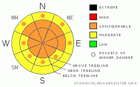
Danger Rose Tutorial
|
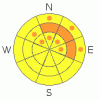
The BOTTOMLINEfor today will be an avalanche danger of CONSIDERABLEfor the La Sal and Abajo mountains. Human triggered avalanches are probable on steep slopes greater than 30 degrees at all elevations, especially on N-NE-E aspects at and above treeline.
Remote triggering is very possible. Avoid traveling under large slide paths. |
|
|
CURRENT CONDITIONS |

|
Blue skies have returned to southeast Utah and a blue sky powder day is on tap for anyone venturing out into the Abajo and La Sal mountains. Do not let "powder fever", "blue-sky syndrome" or any other human factor traps lure you into believing that avalanche terrain is a viable option for today. Mother Nature has been dishing out plenty of signs of instability...all you have to do is keep your faculties about you and notice the recent avalanche activity, whoomphing and shooting cracks around your parties skin or snowmobile track.
Numerous observers in the past two days have confirmed that yes we did have a HIGH avalanche danger for the past 36 hours, where both human and naturally occurring avalanches were likely. Please keep those observations flowing, thank you! We are now getting into the large umbrella of CONSIDERABLE, and we'll more than likely stay here for some time. Please read on for more important information.
San Juan County plowed the Geyser Pass Road yesterday afternoon and LUNA volunteers are heading up this morning to start grooming some of the lower tracks. |
|
|
RECENT ACTIVITY |

|
A snowmobile party triggered an avalanche on the east side of Geyser Pass on Tuesday afternoon. Another party turned tail heading up to the Horsehead in the Abajo's and snow profiles on Julies Backside on Laurel Ridge all confirm that we have an unstable and tender snow pack.
Remote triggering, easy to moderate stability tests with fast, clean shears equate to: You will be your own worst enemy heading into avalanche terrain for the next couple of days. Not only do we have a weak basal layer that avalanches can step down into, the La Sal mountains have a buried surface hoar layer approximately 70 cm down on North-Northeast-East aspects. This IS the sweet spot to trigger buried surface hoar and to the untrained eye, this layer is very deceptive. I suspect that this layer is going to give us some trouble for at least another month or so. Once surface hoar is buried, it doesn't just go away...it persists. |
|
|
THREAT #1 |

|
| WHERE |
PROBABILITY |
SIZE |
TREND |
|
|
|
|
| |
|
|
Over the next
48 hours.
|
|
|
Surface hoar has been buried up to elevations of 11,000' on North-Northeast-East aspects in the La Sal Mountains and possibly in the Abajos. This persistent weak layer, combined with a shallow, faceted snowpack will make triggering an avalanche probable from ridge lines, break overs and buried logs and rocks below treeline. |
|
|
THREAT #2 |

|
| WHERE |
PROBABILITY |
SIZE |
TREND |
|
|
|
|
| |
|
|
Over the next
48 hours.
|
|
|
"Deep" slabs for all intensive purposes are avalanches that will slide on the basal depth hoar surface. We have a shallow snow pack still (less than a meter in most places) and our weight can and will be able to initiate and propagate avalanches on this basal depth hoar layer. |
|
|
MOUNTAIN WEATHER |

|
@ 10,000' in Gold Basin. La Sal Mountains, UTAH
Today: Partly sunny, with a high near 29. Southeast wind around 5 mph becoming west northwest. Tonight: Mostly cloudy, with a low around 18. East wind around 5 mph. Friday: Partly sunny, with a high near 31. Northeast wind around 5 mph. Friday Night: Partly cloudy, with a low around 19. East northeast wind around 5 mph. Saturday: Mostly sunny, with a high near 35. East wind around 5 mph. Saturday Night: Mostly clear, with a low around 20. Sunday: Mostly sunny, with a high near 34 |
|
|
This information does not apply to developed ski areas or highways where avalanche control is normally done. This advisory is from the U.S.D.A. Forest Service, which is solely responsible for its content. This advisory describes general avalanche conditions and local variations always occur. |
|
This advisory provided by the USDA Forest Service, in partnership with:
The Friends of the Utah Avalanche Center, Utah Division of State Parks and Recreation, Utah Division of Emergency Management, Salt Lake County, Salt Lake Unified Fire Authority and the friends of the La Sal Avalanche Center. See our Sponsors Page for a complete list. |
