AVALANCHE WARNING »
Dangerous avalanche conditions are occuring or are imminent.
Backcountry travel in avalanche terrain is not recommended.
|
 |
Notice: An avalanche warning has been posted for the Abajo and La Sal Mountains of Southeast Utah for today and will expire at noon on Thursday, December 15th. This avalanche warning is due to a significant snow load (well over one inch of water) being deposited on a very weak, shallow snowpack.
Human triggered avalanches are likely on all aspects with a slope angle greater than 30 degrees. Remote triggering is a possibility, meaning an avalanche can be triggered from the valley floor. |
|
|
BOTTOM LINE
Danger by aspect and elevation on slopes approaching 35° or steeper.
(click HERE for tomorrow's danger rating)
|
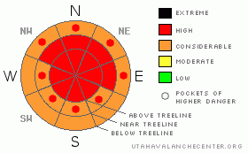
Danger Rose Tutorial
|
The BOTTOMLINE for today will be an AVALANCHE DANGER of High on all aspects and elevations above 9,000' on slope angles greater than 30 degrees. Avalanche terrain should be avoided for at least the next 24 hours. Over one inch of water in the La Sal's and over two inches of water in the Abajos have created a very tender snowpack that can and will be likely triggered by humans traveling in the backcountry.
Remote triggering is a possibility. Traveling below avalanche terrain should be avoided as well. |
|
|
CURRENT CONDITIONS |

|
A low pressure system posted up to southeast Utah late Monday night, and in its wake left some significant snowfall totals. The Abajo mountain range received over 14" of snow with a walloping 2.3" of water content, where the height of snow at Camp Jackson is currently at 30". In the La Sal Mountains, the SNOTEL site near the Geyser Pass Trailhead picked up 10" of snow, for a total of 20" on the ground. In both mountain ranges, the density of the snow exceeded 10%. This warm, cohesive blanket of snow fell with light winds. Wind deposition was limited. The current, light winds on Pre-Laurel and Abajo peaks have veered to the Northwest, indicating the storm has left our region.
The road to the Hart's Draw Parking lot outside Monticello has been plowed, while Iexpect the Geyser Pass road to be worked on starting Thursday morning. You can expect that San Juan County will have the upper two-mile road plowed by early afternoon today.
LUNA volunteers will have their hands full wrestling this heavy snow into a groomed track. No word on the next grooming mission although I feel that we'll have some good product by the weekend. |
|
|
RECENT ACTIVITY |

|
Yesterday's tour to the old Blue Mountain ski area opened our eyes to the current avalanche danger. Low thunder rumbled through our skin track, shooting cracks occurred everywhere and if we were on any steeper of a slope, it would have produced an avalanche. Our added stress to the snow pack were sending waves through the snow, and we could watch half acre dinner plates shatter in place, only to move an inch down the mellow slope.
|
|
|
THREAT #1 |

|
| WHERE |
PROBABILITY |
SIZE |
TREND |
|
|
|
|
| |
|
|
Over the next
24 hours.
|
|
|
There has been an explosion of avalanche dragons. Yesterday's snow stability tests yielded compression tests of very easy (upon isolation), and extended column tests of ECTP11 on the depth hoar interface. The shears were very sudden and planar. There is a poor snowpack structure (heavy over light), a lot of stored energy (Q1 quality shears) and easy stability tests. What this equates to is: If you enter avalanche terrain, you will more than likely meet a nasty avalanche dragon and should be avoided, period. |
|
|
MOUNTAIN WEATHER |

|
@10,000' in Gold Basin, La Sal Mountains
Today: Snow. High near 28. West wind between 5 and 10 mph. Chance of precipitation is 80%. Total daytime snow accumulation of 2 to 4 inches possible.
Tonight: Partly cloudy, with a low around 15. Calm wind becoming southeast around 5 mph.
Thursday: Partly sunny, with a high near 30. East southeast wind around 5 mph becoming calm.
Thursday Night: A 20 percent chance of snow. Mostly cloudy, with a low around 17. Southeast wind around 5 mph becoming northeast.
Friday: A 20 percent chance of snow. Partly sunny, with a high near 32. North northeast wind 5 to 15 mph becoming south southwest.
Friday Night: Partly cloudy, with a low around 18.
Saturday: Mostly sunny, with a high near 34. |
|
|
GENERAL ANNOUNCEMENTS |
Sign up for the AIARELevel I class being held on February 3rd through the 5th. Call Max Forgensi at 435-636-3335 to sign up or for more information. |
|
|
This information does not apply to developed ski areas or highways where avalanche control is normally done. This advisory is from the U.S.D.A. Forest Service, which is solely responsible for its content. This advisory describes general avalanche conditions and local variations always occur. |
|
This advisory provided by the USDA Forest Service, in partnership with:
The Friends of the Utah Avalanche Center, Utah Division of State Parks and Recreation, Utah Division of Emergency Management, Salt Lake County, Salt Lake Unified Fire Authority and the friends of the La Sal Avalanche Center. See our Sponsors Page for a complete list. |
