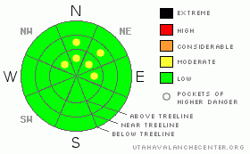
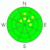
BOTTOM LINE
Danger by aspect and elevation on slopes approaching 35° or steeper.
(click HERE for tomorrow's danger rating)
|
Danger Rose Tutorial
|
Shallow snow depths in the La Sal mountains and marginal coverage in the Abajo's equate to a BOTTOM LINE of LOW, with pockets of MODERATE on E-NE-N-NW slopes at and above treeline in both mountain ranges. Ground hazards will be the biggest concern for back country enthusiasts. The conditions are great to climb a peak, go cross-country skiing or keep your mountain bike out.
It is also a great time to practice with your avalanche beacon, assemble your probe and review strategic shoveling techniques. |
|
|
CURRENT CONDITIONS |

|
The storm that rolled through southeast Utah this past weekend dropped 4-5" in the La Sal mountains while the Abajo mountains received over 12" of snow at Camp Jackson. Current conditions favor the Abajo's for snowsport, 20" of snow dress the Camp Jackson SNOTEL, while only 12" sit at the Geyser Pass Trailhead.
The shallow snow pack in the La Sal mountains keep the ground hazard as the biggest risk for backcountry enthusiasts to scape their skis or break their bones on. A few creamy turns can end in a pile of rocks, defensive skiing is a must in both mountain ranges until we get the first big storm of the 2011-2012 season. Of course, our concern then will be avalanches, please read on.
Saturday December 10th will be the Lower Utah Nordic Alliances kick-off event in the La Sal mountains, the all-volunteer bi-weekly grooming program will make Nordic enthusiasts happy. The Grand County Search and Rescue will be holding their annual training at the Geyser Pass trailhead as well. It will be a busy weekend up in the La Sal mountains, so please drive safely! |
|
|
RECENT ACTIVITY |

|
Current avalanche activity will be limited to steep NW-N-NE faces greater than 35 degrees at or above treeline. Nothing reported, yet a small natural avalanche cycle may have occurred, especially in the Abajos. |
|
|
THREAT #1 |

|
| WHERE |
PROBABILITY |
SIZE |
TREND |
|
|
|
|
| |
|
|
Over the next
48 hours.
|
|
|
Snow has been hanging on Northerly aspects since the Columbus Day season opener. Below the new blanket of snow, expect to find a myriad of facets. Big ones, little ones, all ball-bearings, waiting for a significant load to tip the balance. The current variable conditions and shallow snow pack has fragmented larger avalanche paths, so any human avalanches will occur in isolated locations, be smaller in size and has a greater potential to injure than asphyxiate a skier.
This structurally weak snow pack will be the sliding surface once we get a significant snow event. |
|
|
MOUNTAIN WEATHER |

|
@ 10,000', Flat Ground
Today: Sunny, with a high near 24. Wind chill values as low as -15. East northeast wind around 15 mph becoming west northwest. Tonight: Mostly clear, with a low around 4. North northwest wind around 15 mph. Wednesday: Sunny, with a high near 33. North northeast wind around 15 mph becoming southwest. Wednesday Night: Mostly clear, with a low around 13. West wind around 15 mph becoming east. Thursday: Sunny, with a high near 35. South wind between 10 and 15 mph becoming calm. Thursday Night: Mostly clear, with a low around 9. Friday: Sunny, with a high near 35. |
|
|
GENERAL ANNOUNCEMENTS |
Sign up for our annual AIARE Level I avalanche class being held in Moab from Friday February 3rd through Sunday, February 5th. Call Max Forgensi at 435-636-3335 to sign up or for more information. |
|
|
This information does not apply to developed ski areas or highways where avalanche control is normally done. This advisory is from the U.S.D.A. Forest Service, which is solely responsible for its content. This advisory describes general avalanche conditions and local variations always occur. |
|
This advisory provided by the USDA Forest Service, in partnership with:
The Friends of the Utah Avalanche Center, Utah Division of State Parks and Recreation, Utah Division of Emergency Management, Salt Lake County, Salt Lake Unified Fire Authority and the friends of the La Sal Avalanche Center. See our Sponsors Page for a complete list. |
