SPECIAL ANNOUNCEMENT |
 |
We have ended our avalanche advisories for the season.
This does not mean the end of avalanches, nor the possibility of more avalanche incidents. But the piggy bank has run dry.
But you can continue to share your own avalanche observations with others in the community through our website as usual. Just click on the Submit Observation link on our home page and you can read the observations from others in the Current Conditions off the main menu.
In the sections below, I have outlined some general strategies for avoiding spring avalanches. But first....
We would like to thank everyone who contributed to your community avalanche center, especially all of you who sent in observations of avalanches and general conditions. The more we share our information, the safer we are.
And we would like to especially thank everyone who contributed to the funding of our community avalanche center. We are a Forest Service program but over 3/4 of the funding comes from other partners. This includes: all of your donations through Friends of the Utah Avalanche Center, Utah Division of State Parks and Recreation, Utah Public Safety, Salt Lake County, Black Diamond, Backcountry.com, all the ski areas that donated lift tickets, Ski Utah, Unified Fire Authority and the various shops that donate snowmobiles and other equipment such as Polaris/Tri-City Performance, Weller's Recreation/Ski Doo and Arctic Cat/Big Pine Sports, Recco, Wasatch Backcountry Rescue, Back Country Access and ABS. Whew! Forgive me for anyone I have forgotten. As you can see, we have lots of support and we are the epitome of a successful partnership organization--thanks to you.
You can find our Annual Report by clicking HERE. |
|
|
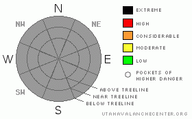
BOTTOM LINE
Danger by aspect and elevation on slopes approaching 35° or steeper.
(click HERE for tomorrow's danger rating)
|
|
|
|
CURRENT CONDITIONS |

|
In our absence, you have a plethora of great information on current conditions:
Snow Page (from the National Weather Service) is one-stop shopping for most everything you will need to know about mountain weather.
SNOTEL Map (from NRCS)
Satellite Imagery (scroll down and click on Infrared > Western US > 2km > Animation)
Radar Imagery (click on the Composite Reflectivity > Loop) |
|
|
RECENT ACTIVITY |

|
Visit the Current Conditions section of our web page to view avalanche activity and general observations. You can also click on Avalanche List for just the list of activity submitted by others. |
|
|
THREAT #1 |

|
| WHERE |
PROBABILITY |
SIZE |
TREND |

|
| No probability identified. |
|
|
|
|
|
Each spring, avalanche conditions generally become more predictable and our avalanche advisories end up repeating themselves like a broken record. So here is the usual spiel:
As my 94-year-old Czech mother-in-law reminds me, “Spring is always a fight between winter and summer.” We have alternating, cold, dry powder storms followed by warm, sunny weather that quickly turns the snowpack soggy.
First for storm snow: we have to worry about the usual round of avalanche activity that occurs during storms, namely instabilities within the new snow and wind slabs. Luckily, in spring, the new snow usually falls on a very stable pre-existing snowpack, so all the monkey business is near the surface. Be sure to use your usual round of tricks like jumping on small test slopes to see how they respond and dig down with your hand to see how well the snow is bonded. Also, you should never commit yourself to a slope without first putting a good slope cut across the slope to test it. If the slope fractures, hopefully, your momentum will take you off the moving slab. And as always, avoid steep slopes with recent wind deposits. |
|
|
THREAT #2 |

|
| WHERE |
PROBABILITY |
SIZE |
TREND |

|
| No probability identified. |
|
|
|
|
|
Between storms, the new snow turns soggy in a hurry with warm temperatures and strong spring sun. Always avoid steep, sun-exposed slopes when they begin to turn wet for the first time. They will often produce roller balls or pinwheels as a precursor to producing larger, wet or damp sluffs.
Second, watch for several unusually warm days in a row because percolating melt water can lubricate and weaken deeply buried weak layers, which produce large, dangerous, wet slabs. We often see these occur during very warm weather after 2 or 3 nights of no freezes or limited freezes, especially on a layered, winter-like snowpack, which has not experienced percolating melt water before. When playing on corn snow (melt-freeze snow) be sure to get out early and head home early—before the snow surface gets punchy.
Third, you need to avoid snow resting on steep, rock slabs, which often produce glide avalanches in which the entire snowpack moves slowly like a glacier until it releases catastrophically. These releases can occur any time of day and counter intuitively seem to release more in the early morning hours, just when you expect it the least. In the Salt Lake mountains, glide avalanches occur like clockwork in places like Stairs Gulch, Broad’s Fork and Mill B South, which are always good places to avoid in spring. |
|
|
THREAT #3 |

|
| WHERE |
PROBABILITY |
SIZE |
TREND |

|
| No probability identified. |
|
|
|
|
|
Cornices are huge this spring and expect them to calve off at any time, but especially during storms and during warm weather. Cornices can trigger larger, deeper avalanches that a person might not be able to trigger. |
|
|
MOUNTAIN WEATHER |

|
Luckily, we also have an embarrassment of riches when it comes to weather forecasting. Here are some links we use regularly:
Cottonwood Canyons Forecast
Graphical forecast for Alta (You can click on any mountain location you want by using the map, which generates a forecast for where you click.)
To get fancy – and – if you know how to read weather maps…
Penn State
U of U time-height sections for SLC (Time is on the bottom axis and height in the atmosphere on the vertical axis—well—you just have to stare at it until it makes sense, but it’s extremely powerful.) |
|
|
GENERAL ANNOUNCEMENTS |
UDOT canyon closures UDOTat (801) 975-4838
We appreciate all your avalanche and snow observations. You can also call us at 801-524-5304 or 800-662-4140, or fill out the observation form on our home page.
Donate to your favorite non-profit –The Friends of the Utah Avalanche Center.The UAC depends on contributions from users like you to support our work.
The information in this advisory is from the U.S. Forest Service, which is solely responsible for its content. This advisory describes general avalanche conditions and local variations always occur. |
|
|
This information does not apply to developed ski areas or highways where avalanche control is normally done. This advisory is from the U.S.D.A. Forest Service, which is solely responsible for its content. This advisory describes general avalanche conditions and local variations always occur. |
|
This advisory provided by the USDA Forest Service, in partnership with:
The Friends of the Utah Avalanche Center, Utah Division of State Parks and Recreation, Utah Division of Emergency Management, Salt Lake County, Salt Lake Unified Fire Authority and the friends of the La Sal Avalanche Center. See our Sponsors Page for a complete list. |


