Moab Avalanche Advisory

Forecaster: Dave Medara

SPECIAL ANNOUNCEMENT

We are winding the season down here at the La Sal Avalanche Center and will only be putting forecasts out 2-3 times per week. Our last forecast will be on the second of April. The Utah Avalanche Center has put together a survey that we'd love for you folks to complete: LINK TO SURVEY. Thanks for a great season.


BOTTOM LINE

Danger by aspect and elevation on slopes approaching 35° or steeper.
(click HERE for tomorrow's danger rating)


Danger Rose Tutorial

Powder skiing and riding is still the name of the game but look for that to change over the next couple of days. Spring ski conditions are just around the corner if the weather forecast is right.

MODERATE avalanche dangers still exist on E-NE-NW facing slopes due to extremely weak snow on these aspects. Expect avalanche dangers on the sunny side slopes to increase to the same level with daytime heating as well.


CURRENT CONDITIONS

We've had another 2-3 inches since last Sunday's forecast and even though we've had some warm temperatures, we haven't turned the corner into spring skiing conditions. Powder skiing is stillthe name of the game in the La Sals and the mountains of SE Utah unless you are skiing very low elevations even still, we haven't had enough cloud free warm weather to see much of a corn cycle. The Mountains of SE Utah are right at 100 percent of normal on the season do the promise of good spring skiing is still out there. The next couple of days should get us into a decent corn cycle provided the weather forecast is valid.

Roads into the Se Utah mountains trailheads are passable but not all plowed. 4wd or chains recommended.

The Lower Utah Nordic Alliance has stopped grooming operations for the 2010-2011 season. Thanks Volunteers!.


RECENT ACTIVITY

Class 2 activity in Gold Basin NE facing reported Saturday. Tele-Heaven on Tukno.


THREAT #1

WHERE PROBABILITY SIZE TREND
      Over the next 24 hours.

Click here for an explanation of the North American Danger Rating system

Weak snow on E-NE-NW facing terrain will keep the avalanche danger at the MODERATE level. High pressure during most of January and February allowed the development of very serious Faceted snow grains in the mid and upper pack that is not healing with continued winter conditions. Dry snow avalanches on these aspects are still possible.


THREAT #2

WHERE PROBABILITY SIZE TREND
No trend identified.

Wet avalanches are likely in the afternoons with a big warm-up over the next couple of days. Don't stay out on sunny slopes too late!


MOUNTAIN WEATHER

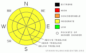
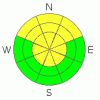
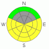
NOAA MOUNTAIN WEATHER FORECAST FOR THE LA SALS @10,000FT:

Tonight:

Mostly cloudy, with a low around 24. Blustery, with a west wind 15 to 20 mph decreasing to between 5 and 10 mph.

Thursday:

Partly sunny, with a high near 47. Calm wind becoming northwest between 10 and 15 mph.

Thursday Night:

Clear, with a low around 32. West northwest wind between 5 and 15 mph.

Friday:

Sunny, with a high near 54. West wind between 5 and 10 mph.

Friday Night:

Mostly clear, with a low around 36. West northwest wind 5 to 10 mph becoming south.

Saturday:

Mostly sunny and breezy, with a high near 56.

Saturday Night:

A chance of rain showers before midnight, then a chance of snow showers. Cloudy and windy, with a low around 31. Chance of precipitation is 50%.

Sunday:

Rain and snow showers likely. Cloudy and windy, with a high near 43.

Sunday Night:

Snow showers likely. Mostly cloudy, with a low around 17.

Monday:

A chance of snow showers. Mostly cloudy, with a high near 36.


GENERAL ANNOUNCEMENTS

We will update this message by Saturday morning.

If you see an avalanche or would like to share any snowpack observations (please do!) you can call us at 435-636-3363, e-mail Dave at : dave@utahavalanche center.org, or use the backcountry observations form here. These observations really help!


This information does not apply to developed ski areas or highways where avalanche control is normally done.  This advisory is from the U.S.D.A. Forest Service, which is solely responsible for its content. This advisory describes general avalanche conditions and local variations always occur.


This advisory provided by the USDA Forest Service, in partnership with:

The Friends of the Utah Avalanche Center, Utah Division of State Parks and Recreation, Utah Division of Emergency Management, Salt Lake County, Salt Lake Unified Fire Authority and the friends of the La Sal Avalanche Center. See our Sponsors Page for a complete list.