Moab Avalanche Advisory

Forecaster: Dave Medara

BOTTOM LINE

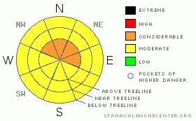
Danger by aspect and elevation on slopes approaching 35° or steeper.
(click HERE for tomorrow's danger rating)


Danger Rose Tutorial

MODERATE to CONSIDERABLE avalanche dangers still exist in the Mountains of SE Utah in the form of new snow and wet slides with daytime warming on steep sunny slopes.

Some fine powder skiing should be found today in the La Sals with 4-6 inches of new overnight.


CURRENT CONDITIONS

It looks like the storm is winding down after dropping 4-6 inches in the La Sals containing up to .7 inches of water. Skiing will be great with relatively well behaved winds during the storm, especially where old re-crystallized powder snow made up the old snow surface. WInter has returned to the Mountains of SE Utah with La Sal trailhead temps in the mid 20's and ridgeline temps in the mid teens. The Abajos came up shot with 1" of new snow being reported from camp Jackson.

Roads into the La Sals have not been cleared so 4wd and chains recommended there, no access problems expected in the Abajos.

La Sal Nordic system will need another buffing and volunteers are getting scarce as we move on to other spring activities. Anyone?


THREAT #1

WHERE PROBABILITY SIZE TREND
      Over the next 24 hours.

Click here for an explanation of the North American Danger Rating system

.7 inches of water on our weak old snowpack will bump up the avalanche danger. Have moved the danger rating up to MODERATE for most areas and CONSIDERABLE (level 3 of 5) on E-NE-NW facing slopes near and above treeline in the La Sal mountains where the new snow load is greatest and the old snow the weakest.

Avalanche Dangers remain at MODERATE in the Abajos, meaning that human triggered avalanches are still possible in some areas and natural avalanches are unlikely. Like the La Sals, likely trouble spots are on E-NE-NW facing slopes.


THREAT #2

WHERE PROBABILITY SIZE TREND
      Over the next 8 hours.

We expect a rise in the avalanche danger for Wet Slides as daytime heating warms up steep sunny slopes. The avalanche danger on steep E-SE-S-SW-W facing slopes will reach MODERATE today with 10,000 foot temperatures forecast to reach 47 degrees. New snow will often get loosened up by the first solar radiation and rapid warming and it might not be that late in the day before it starts!


MOUNTAIN WEATHER

NOAA MOUNTAIN WEATHER FORECAST FOR THE LA SALS @10,000FT:

Friday:

Scattered rain and snow showers after 3pm. Some thunder is also possible. Partly sunny, with a high near 47. Breezy, with a south wind between 15 and 20 mph. Chance of precipitation is 30%.

Friday Night:

Scattered rain and snow showers before 9pm. Some thunder is also possible. Mostly cloudy, with a low around 26. Breezy, with a south wind between 15 and 20 mph. Chance of precipitation is 30%.

Saturday:

Mostly sunny, with a high near 43. Windy, with a south southwest wind between 20 and 30 mph, with gusts as high as 45 mph.

Saturday Night:

Mostly cloudy, with a low around 25. Windy, with a south southwest wind between 20 and 30 mph, with gusts as high as 40 mph.

Sunday:

Partly sunny, with a high near 43.

Sunday Night:

Mostly cloudy, with a low around 24.

Monday:

A slight chance of snow. Mostly cloudy and windy, with a high near 43.

Monday Night:

A chance of snow. Mostly cloudy and windy, with a low around 18.

Tuesday:

A chance of snow. Mostly cloudy and breezy, with a high near 35.


GENERAL ANNOUNCEMENTS

We will update this message by Sunday morning.

If you see an avalanche or would like to share any snowpack observations (please do!) you can call us at 435-636-3363, e-mail Dave at : dave@utahavalanche center.org, or use the backcountry observations form here. These observations really help!


This information does not apply to developed ski areas or highways where avalanche control is normally done.  This advisory is from the U.S.D.A. Forest Service, which is solely responsible for its content. This advisory describes general avalanche conditions and local variations always occur.


This advisory provided by the USDA Forest Service, in partnership with:

The Friends of the Utah Avalanche Center, Utah Division of State Parks and Recreation, Utah Division of Emergency Management, Salt Lake County, Salt Lake Unified Fire Authority and the friends of the La Sal Avalanche Center. See our Sponsors Page for a complete list.