Moab Avalanche Advisory

Forecaster: Dave Medara

BOTTOM LINE

Danger by aspect and elevation on slopes approaching 35° or steeper.
(click HERE for tomorrow's danger rating)


Danger Rose Tutorial

MODERATE avalanche dangers still exist in the Mountains of SE Utah in the form of old persistent slabs on shady sides and wet slides with daytime warming on steep sunny slopes.

Excellent Spring Corn skiing is happening and dry settled powder can be found in sheltered shady terrain. Prime time in SE Utah.


CURRENT CONDITIONS

Another warm day in store for SE Utah. Breezy conditions might slow down the warm up for spring skiing today, but with 10,000 foot temperatures forecast to reach 50 degrees, an early start is always recommended here in SE Utah. Spring corn skiing is happening, and on shady sides, nice dry settled powder snow can be found. Ski both then make it out to Big Bend for a bouldering session? Just a thought. Prime Moab these days...Trailhead temps this morning in the Mid 30's and a good freeze overnight up high. We are at just about 100% of normal snowpack on the season in SE Utah. Enjoy.

Access roads to all the regular SE Utah winter Trailheads have been cleared.

The La Sal Nordic track has been groomed for skate skiing in it's entirety and classic cross-country skiing on the lower end. Thanks Again MATT HEBBARD!


THREAT #1

WHERE PROBABILITY SIZE TREND
      Over the next 24 hours.

Click here for an explanation of the North American Danger Rating system

Avalanche Dangers continue to decline in the Mountains of SE Utah, but only a fool would discount the avalanche danger on steep E-NE-NW facing slopes where weak, sugary faceted old snow grains. are buried in the snowpack between various crusts and stronger snow. Old wind drifts or areas of wind hardened snow over weaker snow are the problem.While unlikely, the possibility of triggering an avalanche into these older layers remains and cannot be dismissed. We are still calling the avalanche danger on these slopes MODERATE or Level 2 - meaning that human triggered avalanches are still possible. ,


THREAT #2

WHERE PROBABILITY SIZE TREND
      Over the next 8 hours.

We expect a rise in the avalanche danger for Wet Slides as daytime heating warms up steep sunny slopes. They might not be that big, but a ride into trees or over cliffs is something to consider. The avalanche danger on steep E-SE-S-SW-W facing slopes will reach MODERATE today with 10,000 foot temperatures forecast to reach 50 degrees. Get an early start if spring corn skiing is your goal!


MOUNTAIN WEATHER

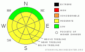
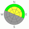
NOAA MOUNTAIN WEATHER FORECAST FOR THE LA SALS @10,000FT:

Today:

Mostly sunny, with a high near 50. Breezy, with a south southwest wind between 15 and 20 mph, with gusts as high as 40 mph.

Tonight:

Areas of blowing snow and a chance of snow after midnight. Mostly cloudy, with a low around 32. Breezy, with a southwest wind between 15 and 25 mph, with gusts as high as 40 mph. Chance of precipitation is 30%.

Thursday:

Snow. High near 43. Breezy, with a south southwest wind between 15 and 20 mph. Chance of precipitation is 80%. New snow accumulation of 2 to 4 inches possible.

Thursday Night:

Snow likely, mainly before midnight. Cloudy, with a low around 20. Breezy, with a west southwest wind between 10 and 20 mph. Chance of precipitation is 60%. New snow accumulation of 2 to 4 inches possible.

Friday:

Partly sunny, with a high near 41. South southeast wind between 5 and 15 mph.

Friday Night:

Mostly cloudy and windy, with a low around 25.

Saturday:

Partly sunny and windy, with a high near 43.

Saturday Night:

Mostly cloudy and windy, with a low around 22.

Sunday:

A chance of snow. Partly sunny and breezy, with a high near 38.

Sunday Night:

A chance of snow. Mostly cloudy, with a low around 20.

Monday:

A chance of snow. Mostly cloudy, with a high near 35.

Monday Night:

A chance of snow. Mostly cloudy, with a low around 18.

Tuesday:

A chance of snow. Mostly cloudy, with a high near 32.


GENERAL ANNOUNCEMENTS

We will update this message by Friday morning.

If you see an avalanche or would like to share any snowpack observations (please do!) you can call us at 435-636-3363, e-mail Dave at : dave@utahavalanche center.org, or use the backcountry observations form here. These observations really help!


This information does not apply to developed ski areas or highways where avalanche control is normally done.  This advisory is from the U.S.D.A. Forest Service, which is solely responsible for its content. This advisory describes general avalanche conditions and local variations always occur.


This advisory provided by the USDA Forest Service, in partnership with:

The Friends of the Utah Avalanche Center, Utah Division of State Parks and Recreation, Utah Division of Emergency Management, Salt Lake County, Salt Lake Unified Fire Authority and the friends of the La Sal Avalanche Center. See our Sponsors Page for a complete list.