Moab Avalanche Advisory

Forecaster: Dave Medara

BOTTOM LINE

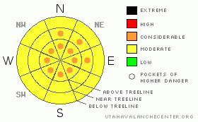
Danger by aspect and elevation on slopes approaching 35° or steeper.
(click HERE for tomorrow's danger rating)


Danger Rose Tutorial

We're at the upper end of the MODERATE danger rating in the mountains of SE Utah this morning with VERY weak old snow on the ground and lingering instabilities possible from the midweek dump. Good skiing and riding conditions can be found in areas sheltered from sun and wind and a little bit of fresh snow overnight won't hurt either.


CURRENT CONDITIONS

Looks like another 1-2 inches has fallen in the Mountains of SE Utah overnight. Good skiing and riding conditions will be on tap in areas sheltered from the sun and winds. Mid elevation E-NE-NW facing slopes would be the call today. The extra fluff will make it even better. With the return of high pressure, We should get into a solid corn snow cycle this coming week. Trailhead temps this morning are in the mid 20's with moderate NW winds.

Road access to the Geyser Pass Trailhead in the La Sals has been plowed and access to the Monticello WInter trailhead has been cleared also. With the new snow, a higher clearance vehicle is recommended if you're going into the La Sals.

Matt Hebbard rolled the entire Nordic track Thursday. Powder skating this morning could be excellent.


THREAT #1

WHERE PROBABILITY SIZE TREND
      Over the next 24 hours.

Click here for an explanation of the North American Danger Rating system

Avalanche Dangers are on the decline in the Mountains of SE Utah but we are not without our trouble spots. It is still winter up in the high country of SE Utah and our snowpack is an unconsolidated mess of layers and faceted old snow grains. Frighteningly weak snow continues to be identified in snowpit analysis in the La Sals. These findings must be taken into account in your decision process when your are deciding on an objective. Still feeling strongly that human triggered avalanche are possible to likely in the elevation zone from about 10,000 feet to 11,500 feet so keeping the avalanche danger at MODERATE w/ pockets of CONSIDERABLE in wind drifted areas on all points of the compass. Danger is more pronounced on E-NE-NW facing slopes where more of our snow has been deposited by our SW winds and the old snow is weakest.


MOUNTAIN WEATHER

NOAA MOUNTAIN WEATHER FORECAST FOR THE LA SALS @10,000FT:

Today:

A 20 percent chance of snow before noon. Partly sunny, with a high near 39. Northwest wind between 10 and 15 mph.

Tonight:

Mostly clear, with a low around 26. North northwest wind around 5 mph becoming calm.

Monday:

Partly sunny, with a high near 42. Breezy, with a south southwest wind 5 to 10 mph increasing to between 15 and 20 mph. Winds could gust as high as 30 mph.

Monday Night:

A 20 percent chance of snow. Mostly cloudy, with a low around 28. Breezy, with a west wind between 10 and 20 mph, with gusts as high as 30 mph.

Tuesday:

Mostly sunny, with a high near 42. Breezy, with a north wind 10 to 20 mph becoming west southwest.

Tuesday Night:

Partly cloudy, with a low around 30.

Wednesday:

Partly sunny and windy, with a high near 50.

Wednesday Night:

A slight chance of snow. Mostly cloudy and windy, with a low around 27.

Thursday:

A chance of rain and snow. Mostly cloudy, with a high near 45.

Thursday Night:

A slight chance of snow. Mostly cloudy, with a low around 24.

Friday:

Mostly sunny, with a high near 48.


GENERAL ANNOUNCEMENTS

We will update this message by Wednesday morning.

If you see an avalanche or would like to share any snowpack observations (please do!) you can call us at 435-636-3363, e-mail Dave at : dave@utahavalanche center.org, or use the backcountry observations form here. These observations really help!


This information does not apply to developed ski areas or highways where avalanche control is normally done.  This advisory is from the U.S.D.A. Forest Service, which is solely responsible for its content. This advisory describes general avalanche conditions and local variations always occur.


This advisory provided by the USDA Forest Service, in partnership with:

The Friends of the Utah Avalanche Center, Utah Division of State Parks and Recreation, Utah Division of Emergency Management, Salt Lake County, Salt Lake Unified Fire Authority and the friends of the La Sal Avalanche Center. See our Sponsors Page for a complete list.