Moab Avalanche Advisory

Forecaster: Dave Medara

BOTTOM LINE

Danger by aspect and elevation on slopes approaching 35° or steeper.
(click HERE for tomorrow's danger rating)


Danger Rose Tutorial

In the La Sals, 14-16 inches of new snow with a minimum of 1.7" of new water weight will create High or Level 4 avalanche dangers. Natural and Human triggered avalanches are almost certain. Large old snow avalanches are likely. Great skiing is being reported in "right side up snow", so lower angles can be ridden and skied.

CONSIDERABLE or Level 3 Avalanche Dangers can be expected in the ABAJOS where 5 inches of new snow was measured containing .5" of new water weight. Human triggered avalanches are possible. Like the La Sals, this new snow is falling on a very weak base of old snow and minimum values of snow and water required for slab avalanche formation are very low.


CURRENT CONDITIONS

Great skiing is on tap in SE Utah once again folks. Mother nature has also provided us with a nice warning in the form of several polite "WHOOMPHS" on the trail yesterday to remind us that with the increase in quality comes the increase in risk should we venture into avalanche terrain. M. cloudy skies yesterday provided sky cover sufficient to keep upper elevation sunny side slopes undamaged by the sun although lower elevations and the tree runs have been baked. Temperatures are in the single digits at Gold Basin this morning and high teens at Trailhead elevation but it it is supposed to be a warm sunny day.. Enjoy.

Road access to the Geyser Pass Trailhead in the La Sals has been groomed and access to the Monticello WInter trailhead has been cleared also.

We're holding off on the grooming program until later in the week.


RECENT ACTIVITY

We'll keep you posted. Nothing noted yesterday but visibility was poor.


THREAT #1

WHERE PROBABILITY SIZE TREND
      Over the next 24 hours.

Click here for an explanation of the North American Danger Rating system

New snow has fallen in a higher to lower density pattern which is good for skiing and avalanche conditions but with this much new snow falling on our old weak snowpack the song remains the same: Expect to find HIGH or LEVEL4 avalanche dangers in the La Sal Mountains with heavy snow falling onto weak older snow. The new snow alone would be enough to create a significant hazard, but with our highly layered and frighteningly weak old snowpack, we can expect avalanches that will take out some off the old snow with it. With the precipitation intensity we had during this storm I would not be surprised if this has happened in many slide paths already.We've measured 16" in Gold Basin and 14" at the La Sal SNOTEL containing 1.7" of water. We are well over critical values for snow depth and water weight. Natural and Human triggered avalanches are likely! Heads up!

Avalanche dangers will be CONSIDERABLE in the Abajo Mountains where 5" of new snow containing .5" h2o has been measured. Human triggered avalanches possible especially on SE-E-NE facing slopes.


THREAT #2

WHERE PROBABILITY SIZE TREND
      Over the next 8 hours.

We expect the avalanche danger to rise to MODERATEtoday on sunny E-SE-SW-W facing slopes as warm temperatures and solar radiation affect the snow for the first time since the storm. Don't stay out on these sunny slopes too late in the day and keep in mind that solar radiation is often a trigger for avalanches right after a storm.


MOUNTAIN WEATHER

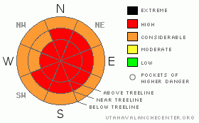
NOAA MOUNTAIN WEATHER FORECAST FOR THE LA SALS @10,000FT:

Today:

Mostly sunny, with a high near 42. Calm wind becoming west northwest around 5 mph. Winds could gust as high as 25 mph.

Tonight:

Partly cloudy, with a low around 23. Calm wind becoming southeast around 5 mph. Winds could gust as high as 25 mph.

Thursday:

Mostly sunny, with a high near 48. Southeast wind around 5 mph becoming southwest. Winds could gust as high as 25 mph.

Thursday Night:

Mostly cloudy, with a low around 33. South wind between 5 and 15 mph, with gusts as high as 30 mph.

Friday:

Mostly sunny, with a high near 41. Breezy, with a west northwest wind between 15 and 20 mph.

Friday Night:

Mostly clear, with a low around 28.

Saturday:

Mostly cloudy and breezy, with a high near 42.

Saturday Night:

A chance of snow. Mostly cloudy and breezy, with a low around 24.

Sunday:

A slight chance of snow. Partly sunny, with a high near 38.

Sunday Night:

Partly cloudy, with a low around 23.

Monday:

Mostly sunny, with a high near 37.

Monday Night:

Mostly cloudy, with a low around 27.

Tuesday:

Partly sunny, with a high near 43.


GENERAL ANNOUNCEMENTS

We will update this message Friday morning.

If you see an avalanche or would like to share any snowpack observations (please do!) you can call us at 435-636-3363, e-mail Dave at : dave@utahavalanche center.org, or use the backcountry observations form here. These observations really help!


This information does not apply to developed ski areas or highways where avalanche control is normally done.  This advisory is from the U.S.D.A. Forest Service, which is solely responsible for its content. This advisory describes general avalanche conditions and local variations always occur.


This advisory provided by the USDA Forest Service, in partnership with:

The Friends of the Utah Avalanche Center, Utah Division of State Parks and Recreation, Utah Division of Emergency Management, Salt Lake County, Salt Lake Unified Fire Authority and the friends of the La Sal Avalanche Center. See our Sponsors Page for a complete list.