Moab Avalanche Advisory

Forecaster: Dave Medara

BOTTOM LINE

Danger by aspect and elevation on slopes approaching 35° or steeper.
(click HERE for tomorrow's danger rating)


Danger Rose Tutorial

Nice snow, Light winds, sun and incredible desert views should be on tap for those heading into the mountains of SE Utah. Avalanche Dangers remain mostly at the MODERATE or LEVEL 2 stage although care must be taken along higher elevation ridgelines to note if winds from the N and NW during this last storm have created slabs or drifted snow onto your intended slope. 3-5 inches of new snow with very little drifting is what we found yesterday and conditions were really good.


CURRENT CONDITIONS

On a Stroll up the Laurel Highway yesterday we found 3-5 inches of new snow and some excellent skiing conditions in the N. Woods. For the first time since early January, we had a little snow that fell straight down out of the sky. Wind drifting (slab formation) was very limited and we saw no avalanche activity. Skiing and riding conditions today will be excellent. Winds from the Northwest continue and it still feels like winter in the Mountains with Temperatures at the Geyser Pass Trailhead of 15 degrees. It is 9 degrees at the Gold Basin study plot at 10,000 ft.

Road Access to SE Utah Mountain Trailheads has not been cleared yet this morning. 4WD and Chains recommended. there was enough traffic yesterday to make the road to Geyser Pass quite easy if you have a vehicle with any clearance.

No grooming has yet been done on the La Sal Nordic system since the storm.


RECENT ACTIVITY

None noted with this last storm


THREAT #1

WHERE PROBABILITY SIZE TREND
      Over the next 24 hours.

Click here for an explanation of the North American Danger Rating system

Dropping danger rating slightly to highlight lack of slab observation in the mountains yesterday and our light winds today. The Avalanche dangers in the Mountains of SE Utah are mostly MODERATE or Level 2, BUT I expect that there may be pockets of elevated or CONSIDERABLE (Level 3) danger in the high country above treeline in areas affected by N. Winds. Do some investigative work before you dive in.

Avalanche dangers will be less severe in the Abajo Mountains where less snow has fallen.


THREAT #2

WHERE PROBABILITY SIZE TREND
No size identified.
      Over the next 24 hours.

Wind crusts, facets, old buried surface hoar. You can find it all in our highly layered snowpack where bridging slabs over weaker layers are a sign of potential trouble. There is a layer about 26" down below the snow surface (at 11,300 feet elevation) that is a mix of buried facets and old surface hoar that is VERY weak. The danger of persistent and/or deep slab releases are a very real threat, particularly with a large storm predicted for our area Monday afternoon. If we get 6-8 inches or more of new snow over the next few days, I expect avalanche activity into old snow on this layer. A great photo of the dirt layer can be seen here, it sits about 10" below the snow surface now and may become a problem later in the season.


THREAT #3

WHERE PROBABILITY SIZE TREND
      Over the next 8 hours.

Watch the daytime warming today with temps forecast into the high 30's. Today will be the first day after the storm for the new snow to absorb solar radiation and this can sometimes result in an avalanche cycle. Some of our sunny S and SE facing slopes may also be loaded by N and NW winds so don't stay out on the sunny sides too late!


MOUNTAIN WEATHER

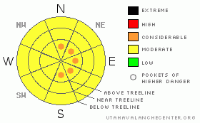
NOAA MOUNTAIN WEATHER FORECAST FOR THE LA SALS @10,000FT:

Today:

Mostly sunny, with a high near 37. South southeast wind 5 to 10 mph becoming west southwest.

Tonight:

Mostly cloudy, with a low around 22. West southwest wind 5 to 10 mph becoming southeast.

Sunday:

A 40 percent chance of snow. Mostly cloudy, with a high near 37. South southwest wind between 5 and 15 mph.

Sunday Night:

A 40 percent chance of snow. Cloudy, with a low around 25. South wind between 5 and 10 mph.

Monday:

Snow. Some thunder is also possible. High near 33. Breezy, with a south wind between 10 and 20 mph. Chance of precipitation is 90%.

Monday Night:

Snow. Low around 16. Breezy. Chance of precipitation is 80%.

Tuesday:

A 50 percent chance of snow. Mostly cloudy and blustery, with a high near 28.

Tuesday Night:

A chance of snow. Mostly cloudy, with a low around 4.

Wednesday:

Mostly sunny, with a high near 33.


GENERAL ANNOUNCEMENTS

We will update this message Sunday morning.

If you see an avalanche or would like to share any snowpack observations (please do!) you can call us at 435-636-3363, e-mail Dave at : dave@utahavalanche center.org, or use the backcountry observations form here. These observations really help!


This information does not apply to developed ski areas or highways where avalanche control is normally done.  This advisory is from the U.S.D.A. Forest Service, which is solely responsible for its content. This advisory describes general avalanche conditions and local variations always occur.


This advisory provided by the USDA Forest Service, in partnership with:

The Friends of the Utah Avalanche Center, Utah Division of State Parks and Recreation, Utah Division of Emergency Management, Salt Lake County, Salt Lake Unified Fire Authority and the friends of the La Sal Avalanche Center. See our Sponsors Page for a complete list.