Moab Avalanche Advisory

Forecaster: Dave Medara

BOTTOM LINE

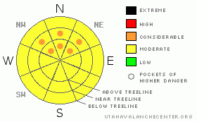
Danger by aspect and elevation on slopes approaching 35° or steeper.
(click HERE for tomorrow's danger rating)


Danger Rose Tutorial

Pockets of CONSIDERABLE or Level 3 avalanche dangers will still be found in the Mountains of SE Utah today with high winds and weak snowpack structures. South winds continue to load NE-N-NW facing slopes so be particularly wary on these points of the compass.

Sheltered NE - NW facing terrain will provide decent skiing and riding conditions, but expect breakable crusts on the sunny sides from a few days of warm temps this week.


CURRENT CONDITIONS

We've had trace amounts of new snow since the last forecast and not much has changed except additional crusting of the sunny side slopes. If we weren't heading for snow in the forecast for 5 out of the next 6 days, another corn cycle would be just around the corner. Upper elevation slopes are a mess. Winds gusting to over 60 mph 4 days ago have done some damage and overall February was a very windy month compared to the relatively calm January we had. Low and Mid elevation shady side slopes that are sheltered from sun and wind remain your best bet for decent turning and riding at the moment. Trailhead temperatures are warm this morning in advance of the next southerly storm at 31 degrees both for Geyser Pass and Camp Jackson in the Abajos this morning. WInds are light to moderate out of the SW

Road access to the Geyser Pass Trailhead, La Sal eastside and the Abajo Mountain winter trailhead have all been cleared.

Matt Hebbard groomed the entire La Sal Nordic track Monday. He deserves a huge thank you from the SE Utah Nordic Community.


RECENT ACTIVITY

Slides from the storm last weekend were noted in Tukno main slide path, Tele-Gold and Red Snow Cirque in Gold Basin. All in the smaller class 2 range.


THREAT #1

WHERE PROBABILITY SIZE TREND
      Over the next 24 hours.

High winds and weak snowpack structures continue to leave us with tender spot out there in the our Southeastern Utah Mountains. South and Southwest winds continue to move snow onto the shady sides - E-NE-NW facing slopes - which is unfortunately where the weakest snow is. Large avalanches running to the ground are being reported in the San Juans and highlight the possibility of this happening here. We are keeping pockets of CONSIDERABLE or LEVEL 3 avalanche danger in the forecast for mid and upper elevation E-NE-NW facing slopes in the mountains of SE Utah. It is not time to "go big" yet. Expect to find a MODERATE or Level 2 avalanche danger elsewhere keeping an eye out for smooth, rounded areas of wind drifted snow.


THREAT #2

WHERE PROBABILITY SIZE TREND
No size identified.
      Over the next 48 hours.

Weak old snow exists to great extent in the Mountains of SE Utah and may take quite some time to adjust to the new snow load on shady side E-NE-NW facing slopes. These slopes have the biggest new load, and the weakest old snow. Winds continue to drift snow onto these aspects. The snow pack received another insult about a week and a half ago in the form of a dirt layer that might give us some issues further down the road. A great photo of the dirt layer can be seen here.


THREAT #3

WHERE PROBABILITY SIZE TREND
      Over the next 8 hours.

Things are going to get warm today (again) and as long as we have temps forecast to reach near 40 we'll keep the possibility of wet slides in the forecast. Don't stay out on the sunny sides too late. Conditions on these aspect are likely to be pretty bad anyways. Increasing clouds today may minimize this problem


MOUNTAIN WEATHER

NOAA MOUNTAIN WEATHER FORECAST FOR THE LA SALS @10,000FT: Looks like a return to winter for the High Country

Today:

Snow likely, mainly after 2pm. Some thunder is also possible. Mostly cloudy, with a high near 39. Breezy, with a south wind 5 to 10 mph becoming west between 15 and 20 mph. Winds could gust as high as 30 mph. Chance of precipitation is 70%. Total daytime snow accumulation of 1 to 2 inches possible.

Tonight:

Snow likely, mainly before 11pm. Cloudy, with a low around 20. West wind between 5 and 10 mph, with gusts as high as 25 mph. Chance of precipitation is 70%. New snow accumulation of 1 to 2 inches possible.

Friday:

Snow likely. Cloudy, then gradually becoming mostly sunny, with a high near 29. West wind between 5 and 10 mph. Chance of precipitation is 70%. New snow accumulation of 1 to 3 inches possible.

Friday Night:

Partly cloudy, with a low around 18. Northwest wind between 5 and 10 mph.

Saturday:

Mostly sunny, with a high near 37. Southeast wind 5 to 15 mph becoming southwest.

Saturday Night:

Mostly cloudy, with a low around 21.

Sunday:

A 40 percent chance of snow. Cloudy, with a high near 38.

Sunday Night:

A chance of snow. Cloudy, with a low around 23.

Monday:

Snow likely. Some thunder is also possible. Cloudy, with a high near 33.

Monday Night:

A chance of snow. Cloudy, with a low around 16.

Tuesday:

A chance of snow. Mostly cloudy, with a high near 24.


GENERAL ANNOUNCEMENTS

We will update this message by Saturday morning, sooner if conditions change.

If you see an avalanche or would like to share any snowpack observations (please do!) you can call us at 435-636-3363, e-mail Dave at : dave@utahavalanche center.org, or use the backcountry observations form here. These observations really help!


This information does not apply to developed ski areas or highways where avalanche control is normally done.  This advisory is from the U.S.D.A. Forest Service, which is solely responsible for its content. This advisory describes general avalanche conditions and local variations always occur.


This advisory provided by the USDA Forest Service, in partnership with:

The Friends of the Utah Avalanche Center, Utah Division of State Parks and Recreation, Utah Division of Emergency Management, Salt Lake County, Salt Lake Unified Fire Authority and the friends of the La Sal Avalanche Center. See our Sponsors Page for a complete list.