Moab Avalanche Advisory

Forecaster: Dave Medara

BOTTOM LINE

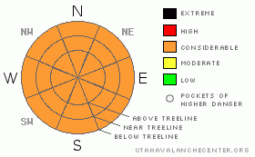
Danger by aspect and elevation on slopes approaching 35° or steeper.
(click HERE for tomorrow's danger rating)


Danger Rose Tutorial

CONSIDERABLE or Level 3 avalanche dangers can be expected in the Mountains of SE Utah today with new snow and blowing snow. Human Triggered avalanches are likely so heads up!

Sheltered NE - NW facing terrain should provide improved skiing and riding conditions but keep the elevations low.


CURRENT CONDITIONS

We've measured 2-5 inches of new snow across the region with lot's of south and southwest winds. Disappointing compared to what they've received in the San Juan Mountains to our east, It looks like echoes are fading on radar images and RH values are going down but the NWS still predicts snow for the mountains today. We'll see. Either way conditions should be much improved. Trailhead temperatures are a mild 26 degrees this morning with continued SW WInds.

Expect snowy roads with drifting possible due to strong SW wInds, 4wd chains and shovel recommended.

Grooming on the La Sal Nordic System has been put off until after this storm runs it's course.


THREAT #1

WHERE PROBABILITY SIZE TREND
      Over the next 24 hours.

Considerable or LEVEL3 avalanche dangers will be found in the Mountains of SE Utah on all aspects above 10,000 feet or so. Human triggered avalanches are likely on any steep mountains slopes today. E-NE-NW facing slopes will be particularly sensitive due to strong SW winds that have blown in conjunction with this storm. Areas of cross-loading as well may be possible. We've seen several instances this year of slopes FACING the prevailing wind direction fail due to localized canyon winds. Vigilance required.


THREAT #2

WHERE PROBABILITY SIZE TREND
No size identified.
No trend identified.

Weak old snow exists to great extent in the Mountains of SE Utah and may take quite some time to adjust to the new snow load on shady side E-NE-NW facing slopes. These slopes have the biggest new load, and the weakest old snow. As always, don't push it down here.


MOUNTAIN WEATHER

NOAA MOUNTAIN WEATHER FORECAST FOR THE LA SALS @10,000FT:

Today:

Snow. High near 27. Breezy, with a west southwest wind between 20 and 25 mph, with gusts as high as 40 mph. Chance of precipitation is 90%. Total daytime snow accumulation of 3 to 5 inches possible.

Tonight:

A 20 percent chance of snow before 11pm. Mostly cloudy, with a low around 13. Windy, with a west southwest wind 25 to 30 mph decreasing to between 10 and 15 mph. Winds could gust as high as 40 mph.

Monday:

Mostly sunny, with a high near 34. Breezy, with a south southwest wind between 15 and 25 mph, with gusts as high as 40 mph.

Monday Night:

Partly cloudy, with a low around 19. Breezy, with a south southwest wind between 20 and 25 mph, with gusts as high as 40 mph.

Tuesday:

Sunny, with a high near 38. South wind between 5 and 10 mph, with gusts as high as 20 mph.

Tuesday Night:

Partly cloudy, with a low around 24.

Wednesday:

Partly sunny and breezy, with a high near 41.


GENERAL ANNOUNCEMENTS

We will update this message by Tuesday morning sooner if conditions change.

If you see an avalanche or would like to share any snowpack observations (please do!) you can call us at 435-636-3363, e-mail Dave at : dave@utahavalanche center.org, or use the backcountry observations form here. These observations really help!


This information does not apply to developed ski areas or highways where avalanche control is normally done.  This advisory is from the U.S.D.A. Forest Service, which is solely responsible for its content. This advisory describes general avalanche conditions and local variations always occur.


This advisory provided by the USDA Forest Service, in partnership with:

The Friends of the Utah Avalanche Center, Utah Division of State Parks and Recreation, Utah Division of Emergency Management, Salt Lake County, Salt Lake Unified Fire Authority and the friends of the La Sal Avalanche Center. See our Sponsors Page for a complete list.