BOTTOM LINE
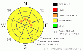
Danger by aspect and elevation on slopes approaching 35° or steeper.
(click HERE for tomorrow's danger rating)
|
Danger Rose Tutorial
|
MODERATE avalanche dangers will present themselves in most areas of SE Utah's mountains this morning, but you can expect to find pockets of CONSIDERABLE or Level 3 dangers along the lee or downwind sides of exposed ridgelines at and above treeline. Avalanche dangers will spike if the forecast amounts of new snow arrive in S. Utah.
Very sheltered shady side slopes NE-NW facing may provide decent skiing or riding conditions. Good luck with that. |
|
|
CURRENT CONDITIONS |

|
The storm that is wreaking havoc in N. Utah has been more blow than snow for us here in S. Utah with just over an inch of new snow being measured at Gold Basin this morning. There is snow in the forecast but I doubt we'll see the type of storm they're seeing up north or even reach warning criteria. Right now as you may have felt at home, the major player is the wind. Strong winds continue out of the South, and Trailhead temperatures are in the mid-20's. I think it's safe to say it will be an inhospitable climate in the mountains today and if anyone finds decent skiing or riding conditions, I'd love to hear about it.
Roads to Geyser Pass, La Sal east side, and Abajo Mountain winter Trailheads have been cleared and with only an inch of new snow at 10,000 feet, should be fine
Grooming on the La Sal Nordic System has been put off until after this storm runs it's course. |
|
|
THREAT #1 |

|
| WHERE |
PROBABILITY |
SIZE |
TREND |
|
|
|
|
| |
|
|
Over the next
24 hours.
|
|
|
MODERATE avalanche danger with pockets of CONSIDERABLE or Level 3 danger continue in the Mountains of SE Utah where the major player is high winds and drifting on upper elevation E-NE-NW facing slopes. Highest hazard zones will be slopes just below upper elevation ridgelines where strong winds from the south are depositing snow.
We keep talking about our old snowpack and how weak it is... Weak snow grains called Faceted Crystals tend to form at and near the surface of the snow pack over cold clear nights at this latitude creating a weak interface for new snow to bond with. These weaknesses, combined with the winds we get here in SE Utah make our "threshold values" for snow and water weight ridiculously low compared to other areas. The snow forecast for southern Utah today and tonight will likely cause a sharp rise in the avalanche danger . |
|
|
MOUNTAIN WEATHER |

|
NOAA MOUNTAIN WEATHER FORECAST FOR THE LA SALS @10,000FT:
Today: Snow. High near 30. Breezy, with a south southwest wind between 15 and 20 mph. Chance of precipitation is 80%. Total daytime snow accumulation of 2 to 4 inches possible. Tonight: Snow. Low around 16. South wind around 15 mph. Chance of precipitation is 80%. New snow accumulation of 4 to 8 inches possible. Sunday: Snow. High near 22. Breezy, with a south southeast wind 15 to 20 mph becoming west southwest. Chance of precipitation is 80%. New snow accumulation of 2 to 4 inches possible. Sunday Night: A 30 percent chance of snow, mainly before 11pm. Mostly cloudy, with a low around 13. Breezy, with a west southwest wind 10 to 20 mph becoming south southeast. Monday: Mostly sunny, with a high near 31. South wind between 5 and 10 mph. Monday Night: Partly cloudy, with a low around 20. Tuesday: Sunny, with a high near 35. |
|
|
GENERAL ANNOUNCEMENTS |
We will update this message Sunday morning.
If you see an avalanche or would like to share any snowpack observations (please do!) you can call us at 435-636-3363, e-mail Dave at : dave@utahavalanche center.org, or use the backcountry observations form here. These observations really help! |
|
|
This information does not apply to developed ski areas or highways where avalanche control is normally done. This advisory is from the U.S.D.A. Forest Service, which is solely responsible for its content. This advisory describes general avalanche conditions and local variations always occur. |
|
This advisory provided by the USDA Forest Service, in partnership with:
The Friends of the Utah Avalanche Center, Utah Division of State Parks and Recreation, Utah Division of Emergency Management, Salt Lake County, Salt Lake Unified Fire Authority and the friends of the La Sal Avalanche Center. See our Sponsors Page for a complete list. |
