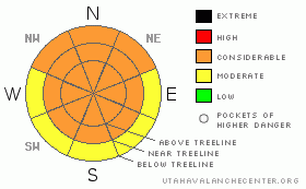
BOTTOM LINE
Danger by aspect and elevation on slopes approaching 35° or steeper.
(click HERE for tomorrow's danger rating)
|
Danger Rose Tutorial
|
Considerable or LEVEL3 avalanche dangers persist in the mountains of SE Utah where weak old snow structures and furious winds have whipped up a combination of localized wind drifts over rotten snow.
Decent skiing and riding conditions can be found in areas sheltered from sun and winds. |
|
|
CURRENT CONDITIONS |

|
The winds in SE Utah have no blown from about every point on the compass over the last 5 days with one characteristic in common - high velocity. Primarily raging from the south, winds have alternately stripped or loaded near and above treeline slopes with violence. There are a lot of newly downed trees. New snow drifts, at least in the La Sals, are easy to spot as they stand out with a red tint against the background of the whiter old snow. Surprisingly, there are still some good skiing and riding conditions to be found on sun and wind sheltered slopes. Think low. Reporting stations this morning show temperatures in the mid-teens to single digits and the winds are expected to rock again today so dress warm. WInter returns to the high country this week. We have 59 inches of snow at our Gold Basin Study Plot which puts us at 98% of normal on the year, the Abajos show 43 inches at Camp Jackson which puts them at 136% of normal.
Roads to Geyser Pass, La Sal east side, and Abajo Mountain winter Trailheads have been cleared. Thank you San Juan County.
Grooming on the La Sal Nordic system was done on the entire track with the roller on Monday and finished with the ginsu groomer on Tuesday. So, the track is set for skate skiing in it's entirety, and classic cross-country track is set into Gold Basin and on all the lower mountains loops. If you see Matt Hebbard, you should buy him lunch, he's the man behind most of this effort. Thanks Matt. |
|
|
RECENT ACTIVITY |

|
Burn-off ridge roadcut produced a large human-triggered slide up to 2.5 feet deep and 150 - 200 feet wide Saturday. This is a result of wind loading and happened BEFORE the bulk of our new snow came in. Remember, the #1 indicator of potential avalanche danger is new avalanches...Check out a photo here.
Slides in Taking Mountain Cirque and Tukno NE face in Gold Basin also ran in the last cycle.
You can submit photos and snowpack or avalanche observations here. Send 'em in!! |
|
|
THREAT #1 |

|
| WHERE |
PROBABILITY |
SIZE |
TREND |
|
|
|
|
| |
|
|
Over the next
48 hours.
|
|
|
Considerable (level 3) Avalanche Danger remains in the Mountains of SE Utah, particularly in the Abajo Mountains where more snow fell in the last storm. Wind slabs in open areas and above treeline will be the primary trouble spots in both mountain ranges with E-NE-NW facing slopes being the larger threat. Some of these areas of wind deposition stand out in relief against the older snow due to the reddish tint of the drifts. These drifts are forming on some very weak old snow structures. Crack and Collapsing were noted by touring parties even yesterday indicating that the old snow has not adjusted to it's new load. Human triggered avalanches remain a strong possibility in the Mountains of SE Utah. |
|
|
MOUNTAIN WEATHER |

|
NOAA MOUNTAIN WEATHER FORECAST FOR THE LA SALS @10,000FT:
Today: Mostly sunny, with a high near 29. Breezy, with a south southwest wind between 15 and 20 mph, with gusts as high as 30 mph. Tonight: A 20 percent chance of snow. Mostly cloudy, with a low around 14. Breezy, with a south southwest wind between 10 and 20 mph, with gusts as high as 30 mph. Thursday: A 30 percent chance of snow after 11am. Mostly cloudy, with a high near 30. Breezy, with a south southwest wind between 15 and 25 mph, with gusts as high as 35 mph. Thursday Night: A 20 percent chance of snow. Cloudy, with a low around 18. Breezy, with a southwest wind between 20 and 25 mph, with gusts as high as 35 mph. Friday: A 30 percent chance of snow. Cloudy, with a high near 32. Breezy, with a south southwest wind between 15 and 20 mph. Friday Night: A 40 percent chance of snow. Cloudy and breezy, with a low around 14. Saturday: Snow likely. Cloudy and breezy, with a high near 30. Chance of precipitation is 60%. Saturday Night: Snow likely. Cloudy and breezy, with a low around 10. Sunday: A chance of snow. Mostly cloudy, with a high near 21. |
|
|
GENERAL ANNOUNCEMENTS |
We will update this message Friday morning.
If you see an avalanche or would like to share any snowpack observations (please do!) you can call us at 435-636-3363, e-mail Dave at : dave@utahavalanche center.org, or use the backcountry observations form here. These observations really help! |
|
|
This information does not apply to developed ski areas or highways where avalanche control is normally done. This advisory is from the U.S.D.A. Forest Service, which is solely responsible for its content. This advisory describes general avalanche conditions and local variations always occur. |
|
This advisory provided by the USDA Forest Service, in partnership with:
The Friends of the Utah Avalanche Center, Utah Division of State Parks and Recreation, Utah Division of Emergency Management, Salt Lake County, Salt Lake Unified Fire Authority and the friends of the La Sal Avalanche Center. See our Sponsors Page for a complete list. |
