Moab Avalanche Advisory

Forecaster: Dave Medara

SPECIAL ANNOUNCEMENT

A new Rescue Sled has been placed at the top of the North Woods to replace the one that was stolen (?!) last year. Thanks to the Alta Ski Patrol for donating that sled to the Grand County Search and Rescue. Thanks also to Ryan Schatzenbach who helped me drag that thing up there. You may now smash yourselves in the N. Woods.

Also, we now have our GOLD BASIN study plot on line with snow totals from 10,000 ft. Yeehaw:

http://mesowest.utah.edu/cgi-bin/droman/meso_base.cgi?stn=GOLDB


BOTTOM LINE

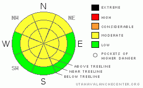
Danger by aspect and elevation on slopes approaching 35° or steeper.
(click HERE for tomorrow's danger rating)


Danger Rose Tutorial

MODERATE or Level 2 avalanche danger still exist in the mountains of SE Utah. Watch for wind slabs in the high country at and above treeline. Avalanche dangers are rising with the new snow that has fallen overnight and continues this morning. Forecast snow totals will definitely bring the avalanche danger to the next level so anticipate this change.


CURRENT CONDITIONS

We've only had 1-2 inches overnight but Relative Humidity values are on the rise and and precipitation rates are increasing. Winds have been nuking and temperatures are on the decline. Looks like the storm is arriving in SE Utah presently so keep fingers crossed. We can really use some new snow.

Roads are still open to the Geyser Pass Trailhead, The La Sal eastside access near Dark Canyon and the Abajo mountain north end access from Monticello. Expect some drifting, especially in the La Sals, so 4wd recommended.

The La Sal Nordic trail system has been groomed in it's entirety but I expect it will be eradicated today.


RECENT ACTIVITY

Cracking and collapsing still being noted in snowpack.

You can submit photos and snowpack or avalanche observations here. Send 'em in!!


THREAT #1

WHERE PROBABILITY SIZE TREND
      Over the next 24 hours.

Dissapointing snow totals so far but winds and new snow totals are already enough to bring the avalanche danger up on upper elevation ridgelines, especially on E-NE-NW facing slopes where wind drifting is occuring. Current Avalanche Dangers remain at MODERATEor Level 2 but are on the rise. We can expect a spike in the avalanche danger based on the current forecast! Heads up today.

This trend will likely continue over the next several days. Our old snowpack is very weak and new snow is unlikely to stay in place. Please play it conservatively over the long weekend. Things aren't that dicey yet but that situation may change.


MOUNTAIN WEATHER

NOAA MOUNTAIN WEATHER FORECAST FOR THE LA SALS @10,000FT:

Today: Snow and widespread blowing snow. High near 29. Windy, with a west wind around 30 mph, with gusts as high as 50 mph. Chance of precipitation is 80%. Total daytime snow accumulation of 3 to 5 inches possible. Tonight: Snow likely before 11pm. Mostly cloudy, with a low around 15. Breezy, with a southwest wind between 10 and 20 mph, with gusts as high as 35 mph. Chance of precipitation is 60%. New snow accumulation of less than a half inch possible. Friday: A 30 percent chance of snow, mainly after 11am. Mostly cloudy, with a high near 33. Breezy, with a south southwest wind between 15 and 20 mph, with gusts as high as 30 mph. Friday Night: A 30 percent chance of snow, mainly before 11pm. Cloudy, with a low around 21. Breezy, with a south southwest wind between 20 and 25 mph, with gusts as high as 35 mph. Saturday: Snow likely. Cloudy, with a high near 34. Windy, with a south southwest wind between 20 and 30 mph, with gusts as high as 45 mph. Chance of precipitation is 70%. Saturday Night: Snow likely. Cloudy and windy, with a low around 20. Chance of precipitation is 70%. Sunday: Snow likely. Cloudy and breezy, with a high near 28. Chance of precipitation is 70%. Sunday Night: A slight chance of snow. Mostly cloudy and breezy, with a low around 11. Washington's Birthday: A slight chance of snow. Partly sunny, with a high near 27. Monday Night: A slight chance of snow. Mostly cloudy, with a low around 12. Tuesday: A chance of snow. Mostly cloudy, with a high near 24. Tuesday Night: A chance of snow. Mostly cloudy, with a low around 11.


GENERAL ANNOUNCEMENTS

We will update this message Friday morning.

If you see an avalanche or would like to share any snowpack observations (please do!) you can call us at 435-636-3363, e-mail Dave at : dave@utahavalanche center.org, or use the backcountry observations form here. These observations really help!


This information does not apply to developed ski areas or highways where avalanche control is normally done.  This advisory is from the U.S.D.A. Forest Service, which is solely responsible for its content. This advisory describes general avalanche conditions and local variations always occur.


This advisory provided by the USDA Forest Service, in partnership with:

The Friends of the Utah Avalanche Center, Utah Division of State Parks and Recreation, Utah Division of Emergency Management, Salt Lake County, Salt Lake Unified Fire Authority and the friends of the La Sal Avalanche Center. See our Sponsors Page for a complete list.