SPECIAL ANNOUNCEMENT |
 |
A new Rescue Sled has been placed at the top of the North Woods to replace the one that was stolen (?!) last year. Thanks to the Alta Ski Patrol for donating that sled to the Grand County Search and Rescue. Thanks also to Ryan Schatzenbach who helped me drag that thing up there. You may now smash yourselves in the N. Woods. |
|
|
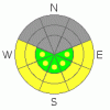
BOTTOM LINE
Danger by aspect and elevation on slopes approaching 35° or steeper.
(click HERE for tomorrow's danger rating)
|

Danger Rose Tutorial
|
MODERATE or Level 2 avalanche danger still exist in the mountains of SE Utah. Watch for wind slabs in the high country at and above treeline. Watch daytime heating. Powder skiing on E-NE-NW facing slopes is your best bet for good skiing and riding conditions. Supportable crusts on sunny side slopes are also starting to form, and we are entering a spring skiing cycle that is likely to end for a while with this new snow. |
|
|
CURRENT CONDITIONS |

|
There are a few echoes out there on the radar this morning as a winter storm moves into our area from the south. We were on the verge of a corn snow cycle before this storm and if snow totals are small from this storm, we may shift right back into it. Spring skiing conditions develop pretty fast when your 10,000 foot high temps reach the mid fifties like they did earlier this week. No matter as it looks like we are going to get new snow down here in SE Utah. Temps are warm this morning and 10,000 ft temperatures are again supposed to reach the mid 40's. Corn skiing may still be possible on S. and SW facing slopes until this storm kicks in tonight. Decent powder conditions can still be on sun and wind protected E-NE-NW facing slopes.
Road conditions are great to the Geyser Pass Trailhead, The La Sal eastside access near Dark Canyon and the Abajo mountain north end access from Monticello.
The La Sal Nordic trail system has been groomed in it's entirety for skate skiing up and over Geyser Pass. Classic cross-country ski grooming has only been done on the Gold Basin Road and Lower Nordic Loops. |
|
|
RECENT ACTIVITY |

|
Cracking and collapsing still being noted in snowpack.
You can submit photos and snowpack or avalanche observations here. Send 'em in!! |
|
|
THREAT #1 |

|
| WHERE |
PROBABILITY |
SIZE |
TREND |

|
|
|
|
| |
|
|
Over the next
48 hours.
|
|
|
We still have some really weak snow pack structures in the SE Utah region. Strong temperature gradients during our recent cold spell probably contributed this weakness. Currently, MODERATE or Level 2 danger can be expected in the Mountains of SE Utah in the form of localized wind slabs over extremely rotten old snow. The high winds are back, this time from the south and whatever snow there is available for transport (not much) will be loaded on the shady North facing terrain with the weakest old snow.
The current snowpack situation in SE Utah is gross. We have a highly layered snowpack with various crust/facet combinations on almost any aspect or elevation you look at. This old snowpack will not hold much of a new load of snow before we enter into another avalanche cycle. We can expect spike in the avalanche danger when and if any new snow starts to pile up. High winds in the forecast further will further enhance wind slab formation and the likelihood of avalanches with even low snow totals. |
|
|
THREAT #2 |

|
| WHERE |
PROBABILITY |
SIZE |
TREND |
|
|
|
|
| |
|
|
Over the next
8 hours.
|
|
|
Today's forecast high of 46 for 10,000 feet means things will be warm in the high country. Expect avalanche dangers to climb to MODERATE (Level 2) with daytime heating. Don't stay out on sunny steeps too late in the day today. Our buried weak layers (discussed in the previous section) are not limited to cold, powder snow and could be activated by heating. Increasing clouds and wind may slow the process down today but beware nonetheless.
Early starts for long approaches are mandatory for spring skiing in the La Sals. Unlike the Wasatch, Sierras or many other mountain ranges, big spring wet slides are not uncommon here. |
|
|
MOUNTAIN WEATHER |

|
NOAA MOUNTAIN WEATHER FORECAST FOR THE LA SALS @10,000FT:
Today: A slight chance of rain and snow after 11am. Partly sunny, with a high near 46. Breezy, with a south wind between 15 and 20 mph, with gusts as high as 45 mph. Chance of precipitation is 20%. Tonight: Snow likely and areas of blowing snow before 11pm, then snow and areas of blowing snow after 11pm. Low around 19. Windy, with a south southwest wind around 30 mph, with gusts as high as 70 mph. Chance of precipitation is 90%. New snow accumulation of 1 to 3 inches possible. Thursday: Snow and areas of blowing snow. High near 31. Windy, with a west southwest wind between 30 and 35 mph, with gusts as high as 55 mph. Chance of precipitation is 80%. New snow accumulation of 1 to 3 inches possible. Thursday Night: Snow likely and areas of blowing snow before 11pm, then a chance of snow after 11pm. Mostly cloudy, with a low around 14. Breezy, with a southwest wind 20 to 25 mph decreasing to between 5 and 10 mph. Winds could gust as high as 45 mph. Chance of precipitation is 60%. New snow accumulation of less than one inch possible. Friday: A 20 percent chance of snow. Mostly cloudy, with a high near 31. South wind between 5 and 15 mph. Friday Night: A 20 percent chance of snow. Mostly cloudy, with a low around 20. Saturday: A 50 percent chance of snow. Cloudy and breezy, with a high near 31. Saturday Night: Snow likely. Cloudy and very windy, with a low around 21. Sunday: Snow likely. Cloudy, with a high near 27. Sunday Night: A chance of snow. Mostly cloudy, with a low around 8. Washington's Birthday: A chance of snow. Mostly cloudy, with a high near 24. Monday Night: A chance of snow. Mostly cloudy, with a low around 11. Tuesday: A chance of snow. Mostly cloudy, with a high near 26. |
|
|
GENERAL ANNOUNCEMENTS |
We will update this message Thursday morning.
If you see an avalanche or would like to share any snowpack observations (please do!) you can call us at 435-636-3363, e-mail Dave at : dave@utahavalanche center.org, or use the backcountry observations form here. These observations really help! |
|
|
This information does not apply to developed ski areas or highways where avalanche control is normally done. This advisory is from the U.S.D.A. Forest Service, which is solely responsible for its content. This advisory describes general avalanche conditions and local variations always occur. |
|
This advisory provided by the USDA Forest Service, in partnership with:
The Friends of the Utah Avalanche Center, Utah Division of State Parks and Recreation, Utah Division of Emergency Management, Salt Lake County, Salt Lake Unified Fire Authority and the friends of the La Sal Avalanche Center. See our Sponsors Page for a complete list. |
