BOTTOM LINE
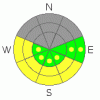
Danger by aspect and elevation on slopes approaching 35° or steeper.
(click HERE for tomorrow's danger rating)
|

Danger Rose Tutorial
|
Great skiing and riding in sheltered areas with wind damage up high. Avalanche Dangers remain at the lower end of CONSIDERABLE or Level 3 due to significant buried weak layers in the old snowpack previous to the Tuesday storm. Watch wet slides as the warm-up starts today. |
|
|
CURRENT CONDITIONS |

|
Temperatures are climbing, but haven't reached seasonal levels this morning with 12 degree temps at 9800 ft. and 6.5 degree temps at Pre-Laurel Peak. Winds continue out of the North in the double digits. Snow moving velocities have been recorded since noon yesterday. These winds just won't let up. Good skiing above treeline might not exist any more. Reports are that there is a lot of wind damage up high. Today will be the last day to ski on sunny side south through west facing slopes as things are finally supposed to warm up. Good skiing and riding conditions are being reported in sheltered area. It looks like a great weekend coming up.
Roads to all SE Utah mountain accesses have been opened up including Geyser Pass, La Sal Eastside and Abajo north end access.
Grooming is scheduled for today. The Entire Nordic track has already been rolled so whatever gets done today will include classic track in addition to the skate skiing that has already been put down. |
|
|
RECENT ACTIVITY |

|
Reports of slides on N. Facing aspects of Gold Basin including Red Snow Cirque and Middle Cirque. Cracking and "Whoomphing" (loud collapses) also reported along Laurel Highway from Tuesday. Thanks for the obs!
You can submit photos and snowpack or avalanche observations here. Send 'em in!! |
|
|
THREAT #1 |

|
| WHERE |
PROBABILITY |
SIZE |
TREND |

|
|
|
|
| |
|
|
Over the next
48 hours.
|
|
|
We've in a period of slowly declining avalanche danger in SE Utah, but our famously weak and sketchy snowpack is still not to be trusted. With avalanches already noted from this last storm and buried weak layers in the form of faceted grains and surface hoar "in the mix" it will be longer than 3 days out from the end of the storm before we can again feel comfortable skiing or riding big lines in the La Sals and to a lesser extent, the Abajos. Winds are a major player here. They just won't let up. Snow continues to be drifted. While the ridgeline winds have been from the N and NW for the last few days, that does not mean that localized winds can't load other aspects deeper in the canyons. Upper elevation SE-S-SW and West facing slopes are most likely candidates for slab avalanches but all aspects at and above treeline should be considered suspect and approached with respect. Avalanche danger Considerable (level 3) at and above treeline, Moderate (level 2) below treeline. Watch for areas of wind drifted snow. |
|
|
THREAT #2 |

|
| WHERE |
PROBABILITY |
SIZE |
TREND |
|
|
|
|
| |
|
|
Over the next
8 hours.
|
|
|
Today is the first day that upper elevation sunny side (and steep) slopes will see solar gain and warm temperatures. Human triggered avalanches will become a real possibility on steep SE - S- SW -W facing slopes as the today's warm-up takes hold. Don't stay out on sunny side slopes too late. |
|
|
MOUNTAIN WEATHER |

|
NOAA MOUNTAIN WEATHER FORECAST FOR THE LA SALS @10,000FT:
Today: Sunny, with a high near 31. Calm wind becoming northwest around 5 mph. Winds could gust as high as 20 mph. Tonight: Mostly clear, with a low around 18. Southeast wind around 5 mph becoming calm. Winds could gust as high as 20 mph. Saturday: Sunny, with a high near 32. Calm wind becoming west northwest around 5 mph. Winds could gust as high as 20 mph. Saturday Night: Mostly clear, with a low around 19. Calm wind becoming southeast around 5 mph. Sunday: Sunny, with a high near 42. South wind around 5 mph becoming calm. Sunday Night: Mostly clear, with a low around 21. Monday: Mostly sunny, with a high near 44. Monday Night: Mostly cloudy, with a low around 23. Tuesday: Mostly sunny, with a high near 43. Tuesday Night: Mostly cloudy, with a low around 21. |
|
|
GENERAL ANNOUNCEMENTS |
We will update this message Saturday morning.
La Sal Mountain Ski Hut Open House @ Tag-a-Long Tours Tomasaki Cabin Feb 12th & 13. www.tagalong.com
If you see an avalanche or would like to share any snowpack observations (please do!) you can call us at 435-636-3363, e-mail Dave at : dave@utahavalanche center.org, or use the backcountry observations form here. These observations really help! |
|
|
This information does not apply to developed ski areas or highways where avalanche control is normally done. This advisory is from the U.S.D.A. Forest Service, which is solely responsible for its content. This advisory describes general avalanche conditions and local variations always occur. |
|
This advisory provided by the USDA Forest Service, in partnership with:
The Friends of the Utah Avalanche Center, Utah Division of State Parks and Recreation, Utah Division of Emergency Management, Salt Lake County, Salt Lake Unified Fire Authority and the friends of the La Sal Avalanche Center. See our Sponsors Page for a complete list. |
