BOTTOM LINE
Danger by aspect and elevation on slopes approaching 35° or steeper.
(click HERE for tomorrow's danger rating)
|
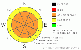
Danger Rose Tutorial
|
Avalanche dangers bumped to CONSIDERABLE or Level 3 with badly needed new snow. As usual winds complicating this scenario here in SE Utah and adding to overall hazard. Skiing and riding conditions will be much improved but keep the slope angles down! |
|
|
CURRENT CONDITIONS |

|
6-8 inches of new snow has fallen in the La Sal Mountains and about half that in the Abajos. We need it badly and the new snow will greatly improve skiing and riding conditions as well as spiking avalanche dangers across SE Utah. Temperatures are cold this morning with mountain sites reporting in the low teens or single digits. Winds are on a downward trend and let's hope they stay that way, we sure could use a break from the north winds that have been ravaging SE Utah. Dress warm and enjoy.
Roads unplowed as of 0700 this morning so expect 4wd conditions. |
|
|
RECENT ACTIVITY |

|
Stay tuned.
You can submit photos and snowpack or avalanche observations here. Send 'em in!! |
|
|
THREAT #1 |

|
| WHERE |
PROBABILITY |
SIZE |
TREND |

|
|
|
|
| |
|
|
Over the next
24 hours.
|
|
|
New snow loads and areas of even deeper drifted snow are falling on a variable, weak old snowpack with many crusts and potential failure layers identified in it. Natural Avalanches are possible and Human Triggered avalanches are likely. Winds have blown from the Southwest and are now switching around to the Northwest so there isn't really a favored "safe zone" and all slopes steeper than 30 degrees in the mountains of SE Utah should be considered suspect. We are calling the Avalanche Danger CONSIDERABLE or Level 3 at this time. |
|
|
MOUNTAIN WEATHER |

|
NOAA MOUNTAIN WEATHER FORECAST FOR THE LA SALS @10,000FT:
Today: Snow. High near 20. North northwest wind between 5 and 10 mph, with gusts as high as 20 mph. Chance of precipitation is 80%. Total daytime snow accumulation of 1 to 2 inches possible. Tonight: A 40 percent chance of snow. Mostly cloudy, with a low around 2. North wind between 10 and 15 mph becoming calm. Winds could gust as high as 25 mph. Wednesday: Mostly sunny, with a high near 21. Calm wind becoming west around 5 mph. Wednesday Night: Mostly cloudy, with a low around 4. West northwest wind 5 to 10 mph becoming east northeast. Thursday: Mostly sunny, with a high near 26. Calm wind becoming north between 5 and 10 mph. Thursday Night: Partly cloudy, with a low around 14. Friday: Sunny, with a high near 33. |
|
|
GENERAL ANNOUNCEMENTS |
We will update this message Tuesday morning.
La Sal Mountain Ski Hut Open House @ Tag-a-Long Tours Tomasaki Cabin Feb 12th & 13. www.tagalong.com
If you see an avalanche or would like to share any snowpack observations (please do!) you can call us at 435-636-3363, e-mail Dave at : dave@utahavalanche center.org, or use the backcountry observations form here. These observations really help! |
|
|
This information does not apply to developed ski areas or highways where avalanche control is normally done. This advisory is from the U.S.D.A. Forest Service, which is solely responsible for its content. This advisory describes general avalanche conditions and local variations always occur. |
|
This advisory provided by the USDA Forest Service, in partnership with:
The Friends of the Utah Avalanche Center, Utah Division of State Parks and Recreation, Utah Division of Emergency Management, Salt Lake County, Salt Lake Unified Fire Authority and the friends of the La Sal Avalanche Center. See our Sponsors Page for a complete list. |
