SPECIAL ANNOUNCEMENT |
 |
Slight update Fri morning. Look for next forecast Saturday morning. |
|
|
BOTTOM LINE
Danger by aspect and elevation on slopes approaching 35° or steeper.
(click HERE for tomorrow's danger rating)
|
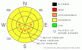
Danger Rose Tutorial
|
POCKETS OF CONSIDERABLE Avalanche Danger remain in La Sal Mountains where we've had 7" (more or less!) of new snow and consistent snow-moving 15-30 (or more!) mph north winds. Less snow has fallen in the Abajos and avalanche dangers will be less in our sister mountains to the south.
Light density new snow has helped but not totally changed the situation here in SE Utah. Even where new snow is at it's deepest, the new snow wasn't enough to cover old crusts and tracks. Pray for more snow this weekend. |
|
|
CURRENT CONDITIONS |

|
Winds nuked yesterday moving the 3-7 inches of light density snow that has fallen in the La Sals. A bit less snow fell in the Abajos. We measured 7" at our Gold Basin study plot, but it wasn't everywhere. Reports are that there is even more than 7" in areas favored by N. winds. We went for a quick tour Wed. to treeline on the Laurel Highway and dropped into the North Woods. The light density snow didn't quite do the job of resetting things in there but conditions were better than before the new snow. Consider that you'll be feeling the old snow surface wherever you might venture, and bring plenty of clothes. High temperature on Pre-Laurel Peak today was -11 F. We all got Ice Cream headaches coasting back into the parking lot after that tour. Things are warming up out there and we have strong inversions with colder temps down here in town than on the mountain.
LaSal trailhead accesses are plowed to Geyser Pass and to the east side. Abajo N. end access is open (and good) as usual.
Matt Hebbard rolled out the Nordic Track into Gold Basin today and packed out a couple of the loops too. Classic track hasn't been set yet but it will be by the weekend. Grooming is scheduled for today. |
|
|
RECENT ACTIVITY |

|
Loose snow sluffs and point releases noted today from Tukno into Tele-Gold and Tele-Heaven. Another small class one sluff was noted in the Middle Cirque above The Throne as well.
You can submit photos and snowpack or avalanche observations here. Send 'em in!! |
|
|
THREAT #1 |

|
| WHERE |
PROBABILITY |
SIZE |
TREND |
|
|
|
|
| |
|
|
Over the next
48 hours.
|
|
|
Try as I might, I just couldn't find a slab Thursday in any of the pits I dug. The new snow - which didn't really have much weight to it - wasn't breaking out any where that we went on our tour today. First of all, there just wasn't that much of it. With only 1/2 an inch of new water weight, there isn't that much of a new load of snow. Secondly - despite all the huff and puff - the North Winds hadn't drifted the new snow to the extent I expected. This comes as a bit of a surprise, the winds have blown, but for some reason the N. Winds haven't gotten to the snow along the Laurel Highway much. I DON'T trust that is is like this everywhere and I recommend caution in this regard.
I am keeping POCKETS OF CONSIDERABLE (level 2) DANGER in the Forecast to reflect the possibility of wind slabs along high ridgelines on sunny aspects AND because of the blustery winds Thursday. Expect to find Moderate avalanche dangers elsewhere, but if traveling in avalanche terrain be very conscious of what the winds have done. There is light density snow available for transport and the avalanche danger where you are might increase.
NATURALAVALANCHESAREBEINGOBSERVEDINTHESANJUANSWITHSIMILARWEATHERANDSNOWPACK
PATTERNSOVERTHELASTFEWDAYS!
|
|
|
THREAT #2 |

|
| WHERE |
PROBABILITY |
SIZE |
TREND |
|
|
|
|
| |
|
|
Over the next
8 hours.
|
|
|
Watch for daytime heating as warmer temperatures and solar energy influence East through South Through West facing slopes today. The rapid re-warming trend forecast by the NWS has arrived and temperatures at higher elevations were on the order of 35 degrees F warmer than they were 24 hours earlier. Expect to find a MODERATE avalanche danger on these aspects in steep mtn. terrain as things heat up. |
|
|
MOUNTAIN WEATHER |

|
NOAA MOUNTAIN WEATHER FORECAST FOR THE LA SALS @10,000FT:
Today: Partly sunny, with a high near 32. North northeast wind between 10 and 15 mph. Tonight: Mostly cloudy, with a low around 17. North northwest wind around 15 mph. Saturday: A 30 percent chance of snow. Mostly cloudy, with a high near 31. North northwest wind between 10 and 15 mph. Saturday Night: A 30 percent chance of snow. Cloudy, with a low around 14. West northwest wind around 5 mph becoming south. Sunday: A 40 percent chance of snow. Mostly cloudy, with a high near 26. Blustery, with a north northwest wind 10 to 15 mph becoming west northwest between 20 and 25 mph. Sunday Night: A 40 percent chance of snow. Mostly cloudy and blustery, with a low around 13. Monday: A 30 percent chance of snow. Mostly cloudy, with a high near 24. Monday Night: A chance of snow. Cloudy and blustery, with a low around 15. Tuesday: A chance of snow. Mostly cloudy, with a high near 23. Tuesday Night: A slight chance of snow. Mostly cloudy, with a low around 3. Wednesday: Mostly sunny, with a high near 22. |
|
|
GENERAL ANNOUNCEMENTS |
We will update this message by Saturday morning.
La Sal Mountain Ski Hut Open House @ Tag-a-Long Tours Tomasaki Cabin Feb 12th & 13. www.tagalong.com
If you see an avalanche or would like to share any snowpack observations (please do!) you can call us at 435-636-3363, e-mail Dave at : dave@utahavalanche center.org, or use the backcountry observations form here. These observations really help! |
|
|
This information does not apply to developed ski areas or highways where avalanche control is normally done. This advisory is from the U.S.D.A. Forest Service, which is solely responsible for its content. This advisory describes general avalanche conditions and local variations always occur. |
|
This advisory provided by the USDA Forest Service, in partnership with:
The Friends of the Utah Avalanche Center, Utah Division of State Parks and Recreation, Utah Division of Emergency Management, Salt Lake County, Salt Lake Unified Fire Authority and the friends of the La Sal Avalanche Center. See our Sponsors Page for a complete list. |
