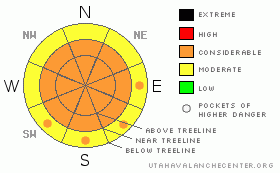
BOTTOM LINE
Danger by aspect and elevation on slopes approaching 35° or steeper.
(click HERE for tomorrow's danger rating)
|
Danger Rose Tutorial
|
CONSIDERABLE Avalanche Danger can be expected in La Sal Mountains where we've had 7" of new snow and consistent snow-moving 15-30 mph north winds. Less snow has fallen in the Abajos and avalanche dangers will be less in our sister mountains to the south.
This badly needed new snow will greatly improve the skiing and riding conditions. Curb your enthusiasm for the steeps right now however. |
|
|
CURRENT CONDITIONS |

|
Some badly needed new snow has finally arrived in SE Utah on a cold northerly flow. In Gold Basin we've measured 7 inches of the white stuff. At the La Sal Snotel site, we've had 6 inches containing 4/10ths of an inch of water. In the Abajos we've only had an inch or two and measured 2/10ths of an inch of water. Measurement sites on the southern end of the Abajos may not be favored in this flow and there may be more snow on the northern end. Same for the La Sals, Skiing and riding conditions will definitely be improving.
No plowing has been done yet. 4WD recommended to reach Trailheads in the La Sals today. The Abajos should have decent access with less snow.
Grooming is on hold until the storm is over. |
|
|
RECENT ACTIVITY |

|
Expect activity with this storm. We'll keep you posted.
You can submit photos and snowpack or avalanche observations here. Send 'em in!! |
|
|
THREAT #1 |

|
| WHERE |
PROBABILITY |
SIZE |
TREND |
|
|
|
|
| |
|
|
Over the next
48 hours.
|
|
|
The new snow we've received is falling onto a patchwork on crusts and wind blown old powder. Weak surface layers and Persistent weak layers in the form of buried faceted crystals and surface hoar have been identified at various depths of the old snowpack. In places where there is enough new snow to slide and the terrain is steep, Natural avalanches will be possible and Human triggered avalanches will be likely. We are just at the threshold of critical amounts of new snow and water in the La Sals. Our snow measurement site at 10,000 ft. is likely to be understating snow totals up high and winds have been up in the 15-30 mph range for the last 12+ hours. These wind speeds will make the winds a major player today and it will be essential to keep an eye out for loaded, or cross-loaded, slopes with wind drifted snow. With the NNW winds we've been having, East thru SE thru West facing slopes will be the most likely for avalanching. We can expect to find CONSIDERABLE or Level 3 avalanche dangers in the La Sal Mountains at this time. MODERATE Danger is more likely to be encountered in the Abajos. More snow is forecast today for the mountains so we may very well see an increase in the overall danger rating today. |
|
|
MOUNTAIN WEATHER |

|
NOAA MOUNTAIN WEATHER FORECAST FOR THE LA SALS @10,000FT:
Today: Snow likely. Cloudy, with a high near 11. North northeast wind between 10 and 15 mph. Chance of precipitation is 70%. Total daytime snow accumulation of 1 to 3 inches possible. Tonight: A 20 percent chance of snow. Mostly cloudy, with a low around -8. Wind chill values as low as -20. North northwest wind between 10 and 15 mph. Wednesday: Mostly sunny, with a high near 11. Wind chill values as low as -25. North wind 10 to 15 mph becoming east southeast. Wednesday Night: Partly cloudy, with a low around -3. Wind chill values as low as -15. North northeast wind between 10 and 15 mph. Thursday: Mostly sunny, with a high near 27. North northwest wind between 5 and 10 mph. Thursday Night: Partly cloudy, with a low around 12. Friday: Mostly sunny, with a high near 32. Friday Night: Partly cloudy, with a low around 13. Saturday: A slight chance of snow. Partly sunny, with a high near 34. |
|
|
GENERAL ANNOUNCEMENTS |
We will update this message by Thursday morning, sooner if conditions change.
La Sal Mountain Ski Hut Open House @ Tag-a-Long Tours Tomasaki Cabin Feb 12th & 13. www.tagalong.com
If you see an avalanche or would like to share any snowpack observations (please do!) you can call us at 435-636-3363, e-mail Dave at : dave@utahavalanche center.org, or use the backcountry observations form here. These observations really help! |
|
|
This information does not apply to developed ski areas or highways where avalanche control is normally done. This advisory is from the U.S.D.A. Forest Service, which is solely responsible for its content. This advisory describes general avalanche conditions and local variations always occur. |
|
This advisory provided by the USDA Forest Service, in partnership with:
The Friends of the Utah Avalanche Center, Utah Division of State Parks and Recreation, Utah Division of Emergency Management, Salt Lake County, Salt Lake Unified Fire Authority and the friends of the La Sal Avalanche Center. See our Sponsors Page for a complete list. |
