BOTTOM LINE
Danger by aspect and elevation on slopes approaching 35° or steeper.
(click HERE for tomorrow's danger rating)
|
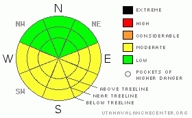
Danger Rose Tutorial
|
Avalanche dangers in the Mountains of SE Utah are mostly LOW or Level 1 right now, but we expect the avalanche danger to rise to MODERATE or Level 2 on sunny slopes due to forecast high temperatures, clear skies and little to no wind.
It is getting tougher and tougher to find good skiing in SE Utah. Very sheltered shady side slopes are the only place where you'll find good snow. After today, we may be able to find some mid-winter corn snow, but it will only be available for harvesting Sunday morning, after that a return to winter weather is forecast. |
|
|
CURRENT CONDITIONS |

|
It is 24 degrees this morning at the La Sal Snotel site at 9800 feet. Temperatures are a likewise balmy 24 degrees on Pre-Laurel peak at 11,700 with light winds from the North. With temperatures down to 19 degrees in Gold Basin we may be experiencing a bit of an inversion with the high pressure ridge camp over the SW US. Today promises to be a warm day so bring the sunscreen and get off sunny side slopes before the get too wet and mushy. Low and mid elevation shady side slopes are your best bet for good turning conditions today. Mucho wind damage up high. We may be getting close to a mid-winter corn snow cycle, but that won't last long given the current weather forecast. More on that below.
All mountain trailhead accesses are open at this time. Geyser Pass, Lasal East side, and the access road to the old Blue Mountain Ski Area are all clear. The La Sal Mountain Loop road is open from the Castle Valley side as well.
All of the La Sal Nordic system has been groomed by Luna Volunteers for classic cross-country and skate skiing. It's the best bet in the La Sals right now for good conditions. Thanks Matt, Kristi and Jesse. |
|
|
RECENT ACTIVITY |

|
We're quite a ways out from any recent activity. An archive of avalanches and terrain photos for SE Utah has been posted under the "current conditions" tab if you are interested.
You can also submit photos and snowpack or avalanche observations here. |
|
|
THREAT #1 |

|
| WHERE |
PROBABILITY |
SIZE |
TREND |
|
|
|
|
| |
|
|
Over the next
48 hours.
|
|
|
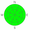
WInd Slabs remain possible in "the Alpine" above treeline. This is most likely in areas loaded, or cross-loaded, with wind drifted snow. Winds have been well behaved for the last 36 hours and we have dropped the avalanche danger to LOW regarding these potential slides but residual danger may still exist for a pocket to pop out.
We DO have buried persistent weak layers buried in our snow pack that are likely to become active when we get a real storm in our region. Weak snowpack structures have been identified and linger in the thinner snowpack areas of both the Abajos and the La Sal Mountains. Near surface faceting will also be occurring during this extended high pressure and avalanche conditions should be predictably spectacular when and if we ever get any more snow. Dig around and see if you can locate buried surface hoar or faceted grains between the Christmas and New Year's storms and above the New Year's storm. You can feel this layering in most areas by poking your pole in the snow. Note the character of the surface snow. This layering is one of the characteristics of our Southwestern Snowpack and might lead to avalanches ripping down into old snow. |
|
|
THREAT #2 |

|
| WHERE |
PROBABILITY |
SIZE |
TREND |
|
|
|
|
| |
|
|
Over the next
8 hours.
|
|
|
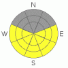
Expect the possibility of wet avalanches, both point releases and slabs, to increase to Moderate or Level 2 as daytime heating weakens the snowpack and highs reach up 43 degrees at 10,000 ft. today with little to no wind. Human triggered wet avalanches are possible when the snow gets warm, wet and mushy. Don't stay out on sunny side slopes too late in the day. |
|
|
MOUNTAIN WEATHER |

|
NOAA MOUNTAIN WEATHER FORECAST FOR THE LA SALS @10,000FT: Breakdown of high pressure and a return to winter expected next week with a chance of snow. Northern parts of UT/CO favored by this pattern at forecast time.
Today: Sunny, with a high near 43. Calm wind. Tonight: Partly cloudy, with a low around 24. Calm wind becoming south southeast around 5 mph. Sunday: Partly sunny, with a high near 33. South wind between 5 and 10 mph. Sunday Night: A 40 percent chance of snow. Mostly cloudy, with a low around 26. South wind between 5 and 10 mph. Monday: A 50 percent chance of snow. Cloudy, with a high near 31. South southeast wind 5 to 15 mph becoming west. Monday Night: A 50 percent chance of snow. Cloudy, with a low around 12. Tuesday: A 30 percent chance of snow. Cloudy, with a high near 27. Tuesday Night: Mostly cloudy, with a low around 0. Wednesday: Partly sunny, with a high near 15. |
|
|
GENERAL ANNOUNCEMENTS |
We will update this message Sunday morning.
La Sal Mountain Ski Hut Open House @ Tag-a-Long Tours Tomasaki Cabin Feb 12th & 13. www.tagalong.com
If you see an avalanche or would like to share any snowpack observations (please do!) you can call us at 435-636-3363, e-mail dave at : dave@utahavalanche center.org, or use the backcountry observations form here. These observations really help! |
|
|
This information does not apply to developed ski areas or highways where avalanche control is normally done. This advisory is from the U.S.D.A. Forest Service, which is solely responsible for its content. This advisory describes general avalanche conditions and local variations always occur. |
|
This advisory provided by the USDA Forest Service, in partnership with:
The Friends of the Utah Avalanche Center, Utah Division of State Parks and Recreation, Utah Division of Emergency Management, Salt Lake County, Salt Lake Unified Fire Authority and the friends of the La Sal Avalanche Center. See our Sponsors Page for a complete list. |
