BOTTOM LINE
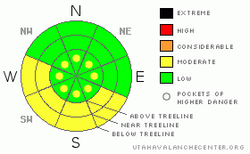
Danger by aspect and elevation on slopes approaching 35° or steeper.
(click HERE for tomorrow's danger rating)
|
Danger Rose Tutorial
|
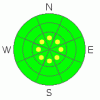
LOW avalanche danger can be expected in all but higher elevation slopes above treeline. Above treeline we've kept the possibility of localized, human triggerable wind slabs in the forecast due to the high winds we've had over the last 5 days. You can expect to find pockets of MODERATE or LEVEL 2 Avalanche danger in the Alpine Zone.
It is getting tougher and tougher to find good skiing in SE Utah. Very sheltered shady side slopes are the only place where you'll find good snow. We really need to freshen things up at this point. |
|
|
CURRENT CONDITIONS |

|
It looks like a nice day today for SE Utah. Yesterday's "storm" was more blow than snow but it looks like we picked up another inch or so overnight. We need it, and could really use more as recent winds and a prolonged high pressure over our mountains have finally gotten the best of our snow quality. Unfortunately, it doesn't look like there is much snow in our future. It's windy and cold this morning, 19 degrees at the Geyser Pass TH and 6 degrees on Pre-Laurel. Winds are blowing out of the east following this storm but are supposed to quiet down. Sheltered E-NE-NW facing slopes are your best bet for finding good skiing or riding conditions.
The Geyser Pass road is buffed. Access to the old Blue Mountain Ski area in the Abajos has been plowed to the base of the hill - very convenient! The La Sal Loop raod is open from Castle Valley to Sand Flats as well.
All of the La Sal Nordic system has been groomed by Luna Volunteers for classic cross-country and skate skiing. It's the best bet in the La Sals right now for good conditions. Thank you Matt and Max. |
|
|
RECENT ACTIVITY |

|
We're quite a ways out from any recent activity. An archive of avalanches and terrain photos for SE Utah has been posted under the "current conditions" tab if you are interested.
You can also submit photos and snowpack or avalanche observations here. |
|
|
THREAT #1 |

|
| WHERE |
PROBABILITY |
SIZE |
TREND |
|
|
|
|
| |
|
|
Over the next
48 hours.
|
|
|
Avalanche Dangers in SE Utah are mostly LOW or LEVEL 1 of 5. There is the possibility of localized windslabs in the alpine terrain above treeline. Winds have been up for the past 5 days so we are keeping pockets of MODERATEor LEVEL2 avalanche danger in the forecast to highlight this point. Human triggered avalanches may still be possible in areas of recent wind deposition. |
|
|
THREAT #2 |

|
| WHERE |
PROBABILITY |
SIZE |
TREND |
|
|
|
|
| |
|
|
Over the next
24 hours.
|
|
|
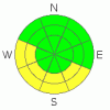
Today will be the first warm day with sun in a couple of days. Watch for wet avalanches on sunny slopes as the day progresses. Expect the Avalanche Danger to rise to MODERATE or LEVEL2 as things heat up. |
|
|
THREAT #3 |

|
| WHERE |
PROBABILITY |
SIZE |
TREND |
|
|
|
|
| |
|
|
Over the next
24
hours.
|
|
|
We have persistent weak layers buried in our SE Utah snowpack. I have been harping on about them for a while now...Buried Surface Hoar and layers of Faceted grains may come back as failure layers when we finally get another real snowstorm. They are more prevalent, observable and REACTIVE in thinner snowpack areas. Take the time to feel around...dig into or poke the snowpack and feel for weaker layers. |
|
|
MOUNTAIN WEATHER |

|
NOAA MOUNTAIN WEATHER FORECAST FOR THE LA SALS @10,000FT:
Today: Mostly sunny, with a high near 38. East wind around 5 mph becoming calm. Winds could gust as high as 25 mph. Tonight: Partly cloudy, with a low around 21. Calm wind becoming southeast around 5 mph. Winds could gust as high as 20 mph. Monday: A 20 percent chance of snow before 11am. Mostly sunny, with a high near 36. North northeast wind around 5 mph, with gusts as high as 25 mph. Monday Night: Partly cloudy, with a low around 19. North wind around 5 mph becoming southeast. Winds could gust as high as 20 mph. Tuesday: A 20 percent chance of snow. Partly sunny, with a high near 36. Calm wind becoming northwest around 5 mph. Tuesday Night: Partly cloudy and blustery, with a low around 19. Wednesday: Sunny and windy, with a high near 35. Wednesday Night: Mostly clear and windy, with a low around 20. Thursday: Sunny and breezy, with a high near 39. |
|
|
GENERAL ANNOUNCEMENTS |
We will update this message Tuesday morning, sooner if conditions change.
The Utah Avalanche Center has a limited number of discount lift tickets available for several Utah Ski Resorts. Follow this link for more information: http://www.backcountry.com/utah-avalanche-center
Our yearly Level 1 class will be held January 28, 29 and 30 of this winter season. The level 1 class focuses on avalanche phenomena, recognition and management of terrain where you might encounter these beasts and basic rescue.
Call 435-636-3363 and speak to Dave or Max for more information or to sign up. |
|
|
This information does not apply to developed ski areas or highways where avalanche control is normally done. This advisory is from the U.S.D.A. Forest Service, which is solely responsible for its content. This advisory describes general avalanche conditions and local variations always occur. |
|
This advisory provided by the USDA Forest Service, in partnership with:
The Friends of the Utah Avalanche Center, Utah Division of State Parks and Recreation, Utah Division of Emergency Management, Salt Lake County, Salt Lake Unified Fire Authority and the friends of the La Sal Avalanche Center. See our Sponsors Page for a complete list. |
