SPECIAL ANNOUNCEMENT |
 |
The LSAC still has room for more folks in both our Level 1 (Jan 28-30) and our Level 2 (Feb 3-6) Avalanche Courses. These courses are provided through the American Institute for Avalanche Research and Education who offer an excellent curriculum and teaching methods. They're also inexpensive!
ALSO - Information for Castle Valley folks. I spoke with the Grand County road Dept. this morning after being asked the Loop Road status between Castle Valley and Sand Flats road. I had assumed the Loop Road would remain closed for the season. The loop road is currently open between Castle Valley and Sand Flats, and (in a change of policy from the past 2 seasons) Grand County will try to keep the road open as much as possible. When it snows, they have higher priorities than the loop road. As time and avalanche danger allow - there is hazard on the N. end of the loop road - they will push the snow from the Loop Road and open it up between Sand Flats and Castle Valley. Good news. |
|
|
BOTTOM LINE
Danger by aspect and elevation on slopes approaching 35° or steeper.
(click HERE for tomorrow's danger rating)
|
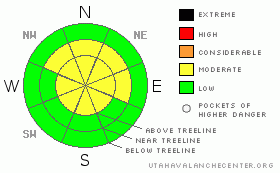
Danger Rose Tutorial
|
The BOTTOM LINE for tomorrow in the Abajo and La Sal Mountains is an avalanche danger of MODERATE or LEVEL 2. Watch for wind slabs in the Alpine Terrain.
Skiing and Riding conditions are decent on E-NE-NW facing slopes and in flat areas but warm temps and wind are whittling away at the goodness. At least it didn't rain on our snow like it did up north. |
|
|
CURRENT CONDITIONS |

|
We finally picked up a bit of snow yesterday afternoon but the amounts are insignificant as we've measured an inch or less accumulation in the mountains of SE Utah. Winds have been the major player for the last 72 hours the zones holding quality settled powder snow have been getting more and more scarce.
We still have 55 inches of snow at the Gold Basin Study Plot, and 28 inches at the La Sal Snotel. We are 123% of normal water in the La Sals and 181% of normal in the Abajos with 38" at 8600 ft at Camp Jackson. OUr percentages of normal are dropping as we get farther and farther out from our last significant precipitation.
The Geyser Pass road is buffed. Access to the old Blue Mountain Ski area in the Abajos has been plowed to the base of the hill - very convenient!
Almost all of the La Sal Nordic system has been groomed by Luna Volunteers . Grooming is scheduled for Friday as well. |
|
|
RECENT ACTIVITY |

|
We're quite a ways out from any recent activity. An archive of avalanches and terrain photos for SE Utah has been posted under the "current conditions" tab if you are interested. |
|
|
THREAT #1 |

|
| WHERE |
PROBABILITY |
SIZE |
TREND |
|
|
|
|
| |
|
|
Over the next
48 hours.
|
|
|
Wind slabs at and above treeline are the most likely offender at this time. We've had more winds over the last 3 days than we've had since December seemingly and the snowpack is reflecting it. In a Gold Basin tour yesterday - where we still found some good snow - had localized areas of slab developing and sections of wind crust as we got higher. Dangerous conditions in the form of wind drifts may be developing in the alpine zone. We are calling the Avalanche Danger MODERATE or LEVEL2 above treeline and at mid elevation on E-NE-NW facing slopes where weaker old snow exists. Winds have been out of the north, so SE-S-SW facing slopes are most likely candidates for wind slab development, but cross loading on other aspects is possible. |
|
|
THREAT #2 |

|
| WHERE |
PROBABILITY |
SIZE |
TREND |

|
|
|
|
| |
|
|
Over the next
24 hours.
|
|
|
We have persistent weak layers buried in our SE Utah snowpack. I have been harping on about them for sure...Buried Surface Hoar and layers of Faceted grains may come back as failure layers when we finally get another real snowstorm. They are more prevalent, observable and REACTIVE in thinner snowpack areas. |
|
|
MOUNTAIN WEATHER |

|
NOAA MOUNTAIN WEATHER FORECAST FOR THE LA SALS @10,000FT:
Today: Mostly sunny, with a high near 33. East northeast wind around 5 mph becoming northwest. Winds could gust as high as 20 mph. Tonight: Partly cloudy, with a low around 17. North northwest wind around 5 mph becoming south southeast. Winds could gust as high as 20 mph. Friday: Mostly sunny, with a high near 35. Calm wind becoming north northwest around 5 mph. Winds could gust as high as 20 mph. Friday Night: Increasing clouds, with a low around 21. North wind around 5 mph becoming south. Winds could gust as high as 20 mph. Saturday: Snow likely. Cloudy, with a high near 33. North northwest wind between 5 and 15 mph. Chance of precipitation is 60%. Saturday Night: A 40 percent chance of snow. Mostly cloudy and blustery, with a low around 13. Sunday: A 20 percent chance of snow. Partly sunny and blustery, with a high near 31. Sunday Night: A slight chance of snow. Mostly cloudy, with a low around 15. Monday: A slight chance of snow. Partly sunny and blustery, with a high near 30. Monday Night: A slight chance of snow. Partly cloudy, with a low around 18. Tuesday: Mostly sunny, with a high near 36. |
|
|
GENERAL ANNOUNCEMENTS |
We will update this message Saturday morning, sooner if conditions change.
The Utah Avalanche Center has a limited number of discount lift tickets available for several Utah Ski Resorts. Follow this link for more information: http://www.backcountry.com/utah-avalanche-center
The LSAC will be offering 2 avalanche classes this year. Our yearly Level 1 class will be held January 28, 29 and 30 of this winter season. The level 1 class focuses on avalanche phenomena, recognition and management of terrain where you might encounter these beasts and basic rescue.
This season, if we can pick up 6 participants, we are also hoping to do a Level 2 class. Tentative dates for the class are February 3-6. It is a 4-day class reviewing the basics covered in level 1, then carrying the subject matter further, exploring snowpack formation, crystal analysis, climactic effects and advanced rescue.
Call 435-636-3363 and speak to Dave or Max for more information or to sign up for one of the classes. |
|
|
This information does not apply to developed ski areas or highways where avalanche control is normally done. This advisory is from the U.S.D.A. Forest Service, which is solely responsible for its content. This advisory describes general avalanche conditions and local variations always occur. |
|
This advisory provided by the USDA Forest Service, in partnership with:
The Friends of the Utah Avalanche Center, Utah Division of State Parks and Recreation, Utah Division of Emergency Management, Salt Lake County, Salt Lake Unified Fire Authority and the friends of the La Sal Avalanche Center. See our Sponsors Page for a complete list. |
