SPECIAL ANNOUNCEMENT |
 |
The LSAC still has room for more folks in both our Level 1 (Jan 28-30) and our Level 2 (Feb 3-6) Avalanche Courses. These courses are provided through the American Institute for Avalanche Research and Education who offer an excellent curriculum and teaching methods. They're also inexpensive! |
|
|
BOTTOM LINE
Danger by aspect and elevation on slopes approaching 35° or steeper.
(click HERE for tomorrow's danger rating)
|
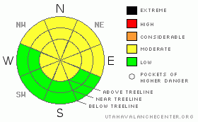
Danger Rose Tutorial
|
The BOTTOM LINE for tomorrow in the Abajo and La Sal Mountains is an avalanche danger of MODERATE or LEVEL 2.
Skiing and Riding conditions are excellent E-NE-NW facing slopes and in flat areas. There is wind damage up high and suncrusts on SE-S-W facing slopes. |
|
|
CURRENT CONDITIONS |

|
The mess that is now the Northern Utah snowpack and the storm totals of the Rockies to our east have all been missed here. No Rain, No snow. About all we've had that is storm related is an increase in winds over the last 2 days. Warmer than average temps continue across the region and overall, not much is changing except the rising snowline.
Great snow conditions for skiing and riding can still be found in the Mountains of SE Utah if you keep the slope aspect away from the sun a ride E-NE-NW facing slopes and flat areas. Good skiing is still being reported from Gold Basin as of 01/19. Warm temperatures haven't damaged the shady aspecs and have helped out with the stability immensely.
We have 55 inches of snow at the Gold Basin Study Plot, and 27 inches at the La Sal Snotel. We are 129% of normal water in the La Sals and 195% of normal in the Abajos with 38" at 8600 ft at Camp Jackson. We're losing snow more rapidly at lower elevations for sure.
The Geyser Pass road is buffed. Access to the old Blue Mountain Ski area in the Abajos has been plowed to the base of the hill - very convenient!
Almost all of the La Sal Nordic system has been groomed by Luna Volunteers . Lower trails were refreshed today. We've tried to add some extra terrain at lower elevations near the trailhead so take advantage folks! Maps are available at the Geyser Pass TH Kiosk. |
|
|
THREAT #1 |

|
| WHERE |
PROBABILITY |
SIZE |
TREND |

|
|
|
|
| |
|
|
Over the next
48 hours.
|
|
|
THIS FORECAST LIVES ON - READ IT AND UNDERSTAND IT - THIS IS STILL OUR MAJOR ISSUE UNTIL WE GET SOME NEW SNOW AND WILL BE A PROBLEM THEN AS WELL
Warmer weather, and a lack of significant precipitation for over 2 weeks are combining to leave us in a rather desirable situation. Good snow - and a less-than-average avalanche danger rating in SE Utah.
Our only problem is the "yellow flags" the we're seeing in the snowpack. While not exactly "red card" disqualifications from skiability, these yellow flags must be taken into account. The snowpack is given "yellow flags" mostly for layering. Layers of snow close to each other with big differences in hardness or grain size are given yellow flags. Layers in the snowpack that are known to be persistent weak layers are given yellow flags especially if they are buried 20-80 CM down from the snow surface. There are a few other yellow flag critieria, and our snowpack - particularly in thinner snow coverage areas - receives 5-6 yellow flags on close inspection. This is a more scientific way of explaining what the old timers have always known and that is: you can't fully trust a snowpack with buried persistent weak layers in it. Buried Surface Hoar from 12/28 and 1/8 result is easy shear tests where these grains can still be found intact.
The take home message here is to stay wary. People are starting to venture deeper into the backcountry. While unlikely, it may still be possible for Human Triggered Avalanches to occur and Avalanche Dangers remain at the MODERATE or LEVEL 2 stage. Localized areas of wind slab at high elevations are most likely areas for triggering. Use good travel skills to minimize the risk. Ski one at a time and wait for others in your party from a safe location. Good travel skills in the backcountry can save your life if you make a bad call regarding snow stability. As we get more aggressive, safe travel protocols become more important.
MORE INFORMATION ON THE "YELLOW FLAG" SYSTEM IS LOCATED HERE. IT IS WORTH A LOOK |
|
|
THREAT #2 |

|
| WHERE |
PROBABILITY |
SIZE |
TREND |
|
|
|
|
| |
|
|
Over the next
24 hours.
|
|
|
Watch for localized areas of wind slab on the normally more stable sunny side slopes. North and Northwest winds have been up in the 20-40 mph range for many hours over the last 2 days. This may cause some drifting of softer powder snow from the shady North faces. |
|
|
MOUNTAIN WEATHER |

|
NOAA MOUNTAIN WEATHER FORECAST FOR THE LA SALS @10,000FT:
Tonight: Mostly cloudy, with a low around 25. West wind 10 to 15 mph becoming south. Wednesday: A 40 percent chance of snow. Cloudy, with a high near 32. Breezy, with a west southwest wind between 15 and 20 mph, with gusts as high as 30 mph. Wednesday Night: A 30 percent chance of snow, mainly before 11pm. Cloudy, then gradually becoming partly cloudy, with a low around 10. Blustery, with a north northwest wind between 20 and 25 mph, with gusts as high as 35 mph. Thursday: Mostly sunny, with a high near 31. Blustery, with a north northeast wind between 15 and 20 mph, with gusts as high as 30 mph. Thursday Night: Partly cloudy, with a low around 15. West northwest wind 10 to 15 mph becoming east northeast. Friday: Mostly sunny, with a high near 35. Friday Night: Mostly cloudy, with a low around 22. Saturday: A chance of snow. Mostly cloudy and breezy, with a high near 35. Saturday Night: A chance of snow. Mostly cloudy, with a low around 13. Sunday: A slight chance of snow. Partly sunny, with a high near 30. |
|
|
GENERAL ANNOUNCEMENTS |
We will update this message Thursday morning, sooner if conditions change.
The Utah Avalanche Center has a limited number of discount lift tickets available for several Utah Ski Resorts. Follow this link for more information: http://www.backcountry.com/utah-avalanche-center
The LSAC will be offering 2 avalanche classes this year. Our yearly Level 1 class will be held January 28, 29 and 30 of this winter season. The level 1 class focuses on avalanche phenomena, recognition and management of terrain where you might encounter these beasts and basic rescue.
This season, if we can pick up 6 participants, we are also hoping to do a Level 2 class. Tentative dates for the class are February 3-6. It is a 4-day class reviewing the basics covered in level 1, then carrying the subject matter further, exploring snowpack formation, crystal analysis, climactic effects and advanced rescue.
Call 435-636-3363 and speak to Dave or Max for more information or to sign up for one of the classes. |
|
|
This information does not apply to developed ski areas or highways where avalanche control is normally done. This advisory is from the U.S.D.A. Forest Service, which is solely responsible for its content. This advisory describes general avalanche conditions and local variations always occur. |
|
This advisory provided by the USDA Forest Service, in partnership with:
The Friends of the Utah Avalanche Center, Utah Division of State Parks and Recreation, Utah Division of Emergency Management, Salt Lake County, Salt Lake Unified Fire Authority and the friends of the La Sal Avalanche Center. See our Sponsors Page for a complete list. |
