SPECIAL ANNOUNCEMENT |
 |
The LSAC still has room for more folks in both our Level 1 (Jan 28-30) and our Level 2 (Feb 3-6) Avalanche Courses. These courses are provided through the American Institute for Avalanche Research and Education who offer an excellent curriculum and teaching methods. They're also inexpensive! |
|
|
BOTTOM LINE
Danger by aspect and elevation on slopes approaching 35° or steeper.
(click HERE for tomorrow's danger rating)
|
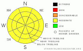
Danger Rose Tutorial
|
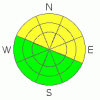
The BOTTOM LINE for today in the Abajo and La Sal Mountains is an avalanche danger of MODERATE or LEVEL 2.
Skiing and Riding conditions are excellent E-NE-NW facing slopes and in flat areas. |
|
|
CURRENT CONDITIONS |

|
Today looks like the last nice day before we enter a period of light snow. Trailhead temps are a very mild 25 degrees F this morning and winds are light from the north. Sunny aspects have seen some sun-crusting and upper elevations have some wind damage, but there is still great settled powder to be found in the Mountains of SE Utah on shadier E-NE-NW facing slopes at low - mid elevations.
Last Wednesday we took a tour down to the Abajos for a bit of a change up. We found some fantastic NE. facing snow, very convenient access, and the lovely feature of not having to put your skins back on to get back to the parking lot after skiing like you do with so many tours in the La Sals. We found about 50 inches of snow at about 10,000 ft over there. Try it out!
We have about 53 inches of snow at the Gold Basin Study Plot, and 31inches at the La Sal Snotel. We are 133% of normal water in the La Sals and 201% of normal in the Abajos with 41" at 8600 ft at Camp Jackson.
The Geyser Pass road was plowed on 1/11/11. It is buffed. Access to the old Blue Mountain Ski area in the Abajos has been plowed to the base of the hill - very convenient!
Almost all of the La Sal Nordic system has been groomed by Matt Hebbard. There are probably 12 miles or so of groomed trails up there and we've tried to add some extra terrain at lower elevations near the trailhead so take advantage folks! Maps are available at the Geyser Pass TH Kiosk. |
|
|
RECENT ACTIVITY |

|
class 1 sluffing in newest snow,
some wet stuff from the last couple of days. |
|
|
THREAT #1 |

|
| WHERE |
PROBABILITY |
SIZE |
TREND |
|
|
|
|
| |
|
|
Over the next
48 hours.
|
|
|
Not much has changed lately in the Mountains of SE Utah. Deeper snowpack areas in the more southerly zones of the La Sals and the Abajos have stronger snow and more northerly reaches of the ranges including Gold Basin and the more accessible parts of the Abajos have weaker snowpacks containing some persistent weak layers. The persistent weak layers are problematic because they are not to be trusted now - human triggered avalanches are still a possibility - or in the future - as a weak layer for old-snow avalanching when we get more snow. Welcome to SE Utah! What this means is that careful analysis of the strength of the snow must be carried out before you dive into that steep E-NE-NW facing slope. MODERATEor Level 2 avalanche dangers still exist in these areas. Low avalanche danger and less than optimum skiing and riding conditions can be expected else where. |
|
|
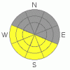
THREAT #2 |

|
| WHERE |
PROBABILITY |
SIZE |
TREND |
|
|
|
|
| |
|
|
Over the next
12 hours.
|
|
|
Expect some wet loose avalanches today as things warm up. Don't stay out on sunny aspects too late. |
|
|
MOUNTAIN WEATHER |

|
NOAA MOUNTAIN WEATHER FORECAST FOR THE LA SALS @10,000FT:
Today: Partly sunny, with a high near 35. East southeast wind between 5 and 10 mph becoming calm.
Tonight: A 30 percent chance of snow. Mostly cloudy, with a low around 21. Calm wind becoming northwest around 5 mph.
Sunday: A 50 percent chance of snow. Mostly cloudy, with a high near 35. West southwest wind between 5 and 10 mph becoming calm. New snow accumulation of less than one inch possible.
Sunday Night: A 40 percent chance of snow. Mostly cloudy, with a low around 23. Northeast wind around 5 mph becoming south.
M.L.King Day: A 50 percent chance of snow. Mostly cloudy, with a high near 36. South wind around 5 mph becoming west northwest.
Monday Night: A 40 percent chance of snow. Mostly cloudy, with a low around 22.
Tuesday: A 20 percent chance of snow. Mostly sunny, with a high near 35.
Tuesday Night: A slight chance of snow. Mostly cloudy, with a low around 20.
Wednesday: A chance of snow. Partly sunny, with a high near 34.
Wednesday Night: A chance of snow. Mostly cloudy, with a low around 22.
Thursday: A chance of snow. Mostly cloudy, with a high near 33. |
|
|
GENERAL ANNOUNCEMENTS |
We will update this message Monday morning, sooner if conditions change.
The Utah Avalanche Center has a limited number of discount lift tickets available for Brian Head Ski Resort. Follow this link for more information: http://www.backcountry.com/utah-avalanche-center
The LSAC will be offering 2 avalanche classes this year. Our yearly Level 1 class will be held January 28, 29 and 30 of this winter season. The level 1 class focuses on avalanche phenomena, recognition and management of terrain where you might encounter these beasts and basic rescue.
This season, if we can pick up 6 participants, we are also hoping to do a Level 2 class. Tentative dates for the class are February 3-6. It is a 4-day class reviewing the basics covered in level 1, then carrying the subject matter further, exploring snowpack formation, crystal analysis, climactic effects and advanced rescue.
Call 435-636-3363 and speak to Dave or Max for more information or to sign up for one of the classes. |
|
|
This information does not apply to developed ski areas or highways where avalanche control is normally done. This advisory is from the U.S.D.A. Forest Service, which is solely responsible for its content. This advisory describes general avalanche conditions and local variations always occur. |
|
This advisory provided by the USDA Forest Service, in partnership with:
The Friends of the Utah Avalanche Center, Utah Division of State Parks and Recreation, Utah Division of Emergency Management, Salt Lake County, Salt Lake Unified Fire Authority and the friends of the La Sal Avalanche Center. See our Sponsors Page for a complete list. |
