SPECIAL ANNOUNCEMENT |
 |
The LSAC still has room for more folks in both our Level 1 (Jan 28-30) and our Level 2 (Feb 3-6) Avalanche Courses. These courses are provided through the American Institute for Avalanche Research and Education who offer an excellent curriculum and teaching methods. They're also inexpensive! |
|
|
BOTTOM LINE
Danger by aspect and elevation on slopes approaching 35° or steeper.
(click HERE for tomorrow's danger rating)
|
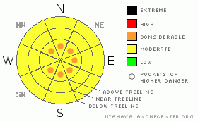
Danger Rose Tutorial
|
The BOTTOM LINE for today in the Abajo and La Sal Mountains is an avalanche danger of MODERATEor LEVEL2.
Skiing and Riding conditions are excellent E-NE-NW facing slopes and in flat areas. |
|
|
CURRENT CONDITIONS |

|
Snowfall totals from the last storm surpassed the forecast amounts with 5-10 inches falling over the Mtns. of SE Utah and cold temperatures moving into the area with it. Skiing and riding conditions are epic. The new snow has settled out significantly so conditions will be better on shady slopes without suncrusts underneath.
We have 57 inches of snow at the Geyser Pass Trailhead.
The Geyser Pass road was plowed on 1/11/11. It is buffed
Cross-country ski trails have been groomed into Gold Basin and the lower Nordic Loop - including some extra mileage. |
|
|
RECENT ACTIVITY |

|
class 1 sluffing in newest snow. |
|
|
THREAT #1 |

|
| WHERE |
PROBABILITY |
SIZE |
TREND |

|
|
|
|
| |
|
|
Over the next
48 hours.
|
|
|
Watch for areas of wind drifted snow on upper elevation ridgelines on all aspects at this point. WInds have been out of several directions over the last 48 hours. With 8-10 inches of new snow from this last storm, there is plenty of snow to move around. I you feel any hollow drum-like sounding snow, stay clear of steeps. We're dropping the avalanche danger to MODERATE or Level 2 but you still need to be on the lookout for wind slabs. |
|
|
THREAT #2 |

|
| WHERE |
PROBABILITY |
SIZE |
TREND |

|
|
|
|
| |
|
|
Over the next
24 hours.
|
|
|
Weaker, highly layered snowpack structures have been identified in the Central Group of the La Sals and quite likely exist in the Northern Group as well. These areas have less snow than the the South Mountains area of the La Sals and the Abajo Mountains.
With both surface hoar and faceted crystals buried in the snowpack between individual storm layers, the snowpack has serious structural issues. In short, you just can't trust it. Heads up on steep E-NE-NW facing slopes in areas with a shallower snowpack. It may still be possible to trigger an avalanche into old snow in these areas, especially with the added weight of yesterday's snow. |
|
|
MOUNTAIN WEATHER |

|
NOAA MOUNTAIN WEATHER FORECAST FOR THE LA SALS @10,000FT:
Today: Partly sunny, with a high near 27. Calm wind becoming west northwest around 5 mph. Tonight: Mostly cloudy, with a low around 12. West wind around 5 mph becoming east. Thursday: Partly sunny, with a high near 34. East northeast wind around 5 mph becoming northwest. Thursday Night: A 20 percent chance of snow. Mostly cloudy, with a low around 17. North northwest wind around 5 mph becoming south. Friday: A 30 percent chance of snow, mainly before 11am. Partly sunny, with a high near 33. Breezy, with a north northwest wind 5 to 10 mph increasing to between 15 and 20 mph. Friday Night: A 20 percent chance of snow after 11pm. Mostly cloudy, with a low around 21. Saturday: A 20 percent chance of snow. Partly sunny, with a high near 35. Saturday Night: A slight chance of snow. Mostly cloudy, with a low around 20. Sunday: A chance of snow. Mostly cloudy, with a high near 34. Sunday Night: A chance of snow. Mostly cloudy, with a low around 21. |
|
|
GENERAL ANNOUNCEMENTS |
We will update this message by Friday morning, sooner if conditions change.
The Utah Avalanche Center has a limited number of discount lift tickets available for Brian Head Ski Resort. Follow this link for more information: http://www.backcountry.com/utah-avalanche-center
The LSAC will be offering 2 avalanche classes this year. Our yearly Level 1 class will be held January 28, 29 and 30 of this winter season. The level 1 class focuses on avalanche phenomena, recognition and management of terrain where you might encounter these beasts and basic rescue.
This season, if we can pick up 6 participants, we are also hoping to do a Level 2 class. Tentative dates for the class are February 3-6. It is a 4-day class reviewing the basics covered in level 1, then carrying the subject matter further, exploring snowpack formation, crystal analysis, climactic effects and advanced rescue.
Call 435-636-3363 and speak to Dave or Max for more information or to sign up for one of the classes. |
|
|
This information does not apply to developed ski areas or highways where avalanche control is normally done. This advisory is from the U.S.D.A. Forest Service, which is solely responsible for its content. This advisory describes general avalanche conditions and local variations always occur. |
|
This advisory provided by the USDA Forest Service, in partnership with:
The Friends of the Utah Avalanche Center, Utah Division of State Parks and Recreation, Utah Division of Emergency Management, Salt Lake County, Salt Lake Unified Fire Authority and the friends of the La Sal Avalanche Center. See our Sponsors Page for a complete list. |
