BOTTOM LINE
Danger by aspect and elevation on slopes approaching 35° or steeper.
(click HERE for tomorrow's danger rating)
|
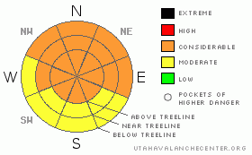
Danger Rose Tutorial
|
The BOTTOM LINE for today in the Abajo and La Sal Mountains is an avalanche danger of Considerable or Level 3 on steep NW-N-NE aspects at and above treeline.
Skiing and riding conditions are excellent. |
|
|
CURRENT CONDITIONS |

|
Unbelievable skiing and riding conditions in the Mountains of SE Utah. Last week's snow fell with decreasing densities and winds making for some of the "Greatest Snow on Earth" right here in Red Rock Country. Pretty Sweet. Oh Yeah, some "Big Ones" (AVALANCHES!) out there too. We have about 60" of snow on the ground at the Gold Basin Study Plot.
The La Sal Loop road has now been plowed but the Geyser Pass road has NOT been plowed yet. San Juan County is currently working on the road to the Geyser Pass Trailhead, and word is that they have it blocked off while the front end loader tries to clear the road as best they can. At this time, the plow is being repaired and they will get to clearing the road properly ASAP, hopefully Tuesday. They really are working hard on this. Thanks Guys!
We'll get back to you on the grooming schedule. |
|
|
RECENT ACTIVITY |

|
Slides being reported so far:
Gold Basin Middle Cirque - R4-5/D3 - What this means is that about 80% of the Middle Cirque came down in one massive avalanche with large destructive force. Yikes.
Gold Basin Red Snow Cirque - R2/D2 - O - What this means is that a small to medium size, but very deep (the O means it ripped into OLD snow) has come out in Red Snow. This highlights the potential for deep destructive avalanches. They are still (as of 01/02/11) getting old snow avalanches with control work over in T-ride with a very similar snowpack to ours.
Geyser Roadcuts. |
|
|
THREAT #1 |

|
| WHERE |
PROBABILITY |
SIZE |
TREND |
|
|
|
|
| |
|
|
Over the next
24 hours.
|
|
|
Avalanche Dangers are currently on the decline with time and consistently cold temperatures, but we still have significant slab build-up and weak, older snow under the latest storm deposits. As usual, heightened precautions must be taken in the SE Utah mountains. Human Triggered avalanches remain a strong possibility. COSIDERABLEor Level 3 avalanche dangers should be expected in the La Sal and Abajo Mountains. |
|
|
THREAT #2 |

|
| WHERE |
PROBABILITY |
SIZE |
TREND |

|
|
|
|
| |
|
|
Over the next
48 hours.
|
|
|
Although our snow pack is deeper than average, it has plenty of weak layers sandwiched within it. Buried surface hoar in sheltered northerly locations while old wind slabs are overlying faceted layers in wind affected locations.
Avalanches ripping into old snow have been noted in the La Sals and in Telluride as recently as yesterday. You do not want to trigger one of these. |
|
|
MOUNTAIN WEATHER |

|
NOAA MOUNTAIN WEATHER FORECAST FOR 10,000FT: Climbing back towards seasonal temps.
This Afternoon: A 50 percent chance of snow. Cloudy, with a high near 23. Northwest wind around 15 mph. Total daytime snow accumulation of around an inch possible.
Tonight: A 40 percent chance of snow. Cloudy, with a low around 9. West wind 5 to 15 mph becoming east.
Tuesday: A 40 percent chance of snow. Mostly cloudy, with a high near 29. East southeast wind 5 to 15 mph becoming west.
Tuesday Night: A 20 percent chance of snow. Mostly cloudy, with a low around 10. West wind 5 to 15 mph becoming north.
Wednesday: Partly sunny, with a high near 27. Northwest wind around 5 mph.
Wednesday Night: Mostly cloudy, with a low around 12.
Thursday: Partly sunny, with a high near 31.
Thursday Night: Partly cloudy, with a low around 20.
Friday: Partly sunny, with a high near 33.
Friday Night: Mostly cloudy, with a low around 21.
Saturday: Partly sunny, with a high near 32. |
|
|
GENERAL ANNOUNCEMENTS |
We will update this message by Thursday morning. Sooner if conditions change.
The LSAC will be offering 2 avalanche classes this year. Our yearly Level 1 class will be held January 28, 29 and 30 of this winter season. The level 1 class focuses on avalanche phenomena, recognition and management of terrain where you might encounter these beasts and basic rescue.
This season, if we can pick up 6 participants, we are also hoping to do a Level 2 class. Tentative dates for the class are February 3-6. It is a 4-day class reviewing the basics covered in level 1, then carrying the subject matter further, exploring snowpack formation, crystal analysis, climactic effects and advanced rescue.
Call 435-636-3363 and speak to Dave or Max for more information or to sign up for one of the classes. |
|
|
This information does not apply to developed ski areas or highways where avalanche control is normally done. This advisory is from the U.S.D.A. Forest Service, which is solely responsible for its content. This advisory describes general avalanche conditions and local variations always occur. |
|
This advisory provided by the USDA Forest Service, in partnership with:
The Friends of the Utah Avalanche Center, Utah Division of State Parks and Recreation, Utah Division of Emergency Management, Salt Lake County, Salt Lake Unified Fire Authority and the friends of the La Sal Avalanche Center. See our Sponsors Page for a complete list. |
