AVALANCHE WATCH »
The risk of an avalanche is expected to increase significantly
but the timing and location are still uncertain. Stay tuned for updates.
|
 |
Notice: An Avalanche Watch has been issued for the mountains of SE Utah including the La Sal and Abajo Mountains. Strong winds and heavy snowfall will create an increasing avalanche danger today through Thursday. Both human triggered and natural avalanches are possible. Backcountry travelers need excellent terrain and snowpack evaluation skills and should avoid steep slopes and avalanche runout zones. |
|
|
SPECIAL ANNOUNCEMENT |
 |
Happy Holidays from Dave and Max at the Avi Center!
There is a FREE avalanche awareness talk at the Grand County Library on January 11, 2011 at 5:30 PM. Everyone is invited! |
|
|
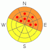
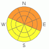
BOTTOM LINE
Danger by aspect and elevation on slopes approaching 35° or steeper.
(click HERE for tomorrow's danger rating)
|
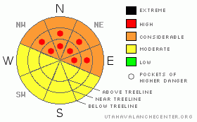
Danger Rose Tutorial
|
CONSIDERABLE (Level 3) Avalanche Danger with pockets of HIGH(Level 4) danger on E-NE-NW facing near and above treeline in the Mountains of SE Utah. Human triggered avalanches are likely.
Great skiing and riding on all but South facing slopes. Keep the slope angles below 30 degrees or about as steep as a black diamond run at a ski area.
Expect another rise in the Avalanche Danger as another winter storm Continues over SE Utah through Friday. |
|
|
CURRENT CONDITIONS |

|
Excellent Skiing and Riding conditions continue in the Mountains of SE Utah. Reports are that conditions are primo. 3-6 inches of new snow has already fallen in the La Sals and the Abajos have had even more.
The road to the Geyser Pass Trailhead has been plowed but expect 4WD conditions already.
Grooming scheduled for Friday on the La Sal Nordic Trails. |
|
|
RECENT ACTIVITY |

|
La Sal Roadcuts already sliding as of AM Wednsday. Snowpack expected to get active again.
Spectacular viewing Friday from Pre-Laurel peak wx-station. Lots of Avalanches on display. Pretty near all the north facing slopes in Gold Basin have produced avalanches at some time during the storm. Horse Creek also. Many are mostly covered up having run early in the storm but some ran later and are highly visible. Most impressive is the Mt. Peale slide that appears to be about a mile wide. Here's some photos:
Mt. Peale and Laurel Cirque - Mt. Peale avi is on upper ridge in the shade of this photo, Laurel Cirque avi is in the foreground on the sunnier slope.
Talking Mountain Cirque - Most of the bowl came out - several photos
Here's another, better shot of the massive Mt. Peale slide here. There are also some interesting pictures of the riming that took place in the last storm.
Additional Class 2-3 activity in Middle Cirque, Tuk N. Face, Tukno NE face in both Tele-heaven and Tele-Gold, Exxon's Folley and Noriega's Face. |
|
|
THREAT #1 |

|
| WHERE |
PROBABILITY |
SIZE |
TREND |
|
|
|
|
| |
|
|
Over the next
48 hours.
|
|
|
Avalanche dangers approaching HIGH or Level 4 already with new snow and high winds. Strong 30-50 mph winds and snow are pounding in new slabs of snow on E-NE-NW facing slopes and other areas that may be cross-loaded. Storm is expected to last through Friday so we are just getting into this avalanche cycle. Heads up! |
|
|
THREAT #2 |

|
| WHERE |
PROBABILITY |
SIZE |
TREND |
|
|
|
|
| |
|
|
Over the next
48 hours.
|
|
|
It may be possible to trigger big Avi's into old snow where avalanches did not run in the last cycle. Be afraid. |
|
|
MOUNTAIN WEATHER |

|
National Weather Service Forecast for 10,000 feet: More snow and a big cool down.
This Afternoon: Snow and areas of blowing snow. High near 28. Breezy, with a south wind around 25 mph, with gusts as high as 45 mph. Chance of precipitation is 90%. Total daytime snow accumulation of 5 to 9 inches possible. Tonight: Snow and areas of blowing snow. Low around 11. Breezy, with a south southwest wind between 15 and 20 mph, with gusts as high as 40 mph. Chance of precipitation is 100%. New snow accumulation of 5 to 9 inches possible. Thursday: Snow and areas of blowing snow. High near 13. Wind chill values as low as -10. West wind between 10 and 15 mph, with gusts as high as 35 mph. Chance of precipitation is 100%. New snow accumulation of 5 to 9 inches possible. Thursday Night: Snow. Low around -4. Wind chill values as low as -20. West southwest wind around 15 mph, with gusts as high as 35 mph. Chance of precipitation is 90%. New snow accumulation of 5 to 9 inches possible. Friday: Snow. High near 11. West northwest wind around 10 mph. Chance of precipitation is 80%. Friday Night: A 20 percent chance of snow. Mostly cloudy, with a low around -9. New Year's Day: Mostly sunny, with a high near 11. |
|
|
GENERAL ANNOUNCEMENTS |
We will update this message on Friday Morning.
The LSAC will be offering 2 avalanche classes this year. Our yearly Level 1 class will be held January 28, 29 and 30 of this winter season. The level 1 class focuses on avalanche phenomena, recognition and management of terrain where you might encounter these beasts and basic rescue.
This season, if we can pick up 6 participants, we are also hoping to do a Level 2 class. Tentative dates for the class are February 3-6. It is a 4-day class reviewing the basics covered in level 1, then carrying the subject matter further, exploring snowpack formation, crystal analysis, climactic effects and advanced rescue.
Call 435-636-3363 and speak to Dave or Max for more information or to sign up for one of the classes. |
|
|
This information does not apply to developed ski areas or highways where avalanche control is normally done. This advisory is from the U.S.D.A. Forest Service, which is solely responsible for its content. This advisory describes general avalanche conditions and local variations always occur. |
|
This advisory provided by the USDA Forest Service, in partnership with:
The Friends of the Utah Avalanche Center, Utah Division of State Parks and Recreation, Utah Division of Emergency Management, Salt Lake County, Salt Lake Unified Fire Authority and the friends of the La Sal Avalanche Center. See our Sponsors Page for a complete list. |
