SPECIAL ANNOUNCEMENT |
 |
Happy Holidays from Dave and Max at the Avi Center!
There is a FREE avalanche awareness talk at the Grand County Library on January 11, 2011 at 5:30 PM. Everyone is invited! |
|
|
BOTTOM LINE
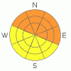
Danger by aspect and elevation on slopes approaching 35° or steeper.
(click HERE for tomorrow's danger rating)
|

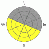
Danger Rose Tutorial
|
CONSIDERABLE (Level 3) Avalanche Danger can still be encountered in Mountains of SE Utah. Travel with caution as there is still potential for some big avalanches.
Great skiing and riding on all but South facing slopes. Keep the slope angles below 30 degrees or about as steep as a black diamond run at a ski area.
Expect another rise in the Avalanche Danger as another winter storm heads our way for Wed/Thurs. |
|
|
CURRENT CONDITIONS |

|
Excellent Skiing and Riding conditions continue in the Mountains of SE Utah. Due south facing slopes have been crusted over by the sun bit on all other aspects, reports are that conditions are primo. 2 more inches of fluff on Sunday did not hurt either. We are now at 121 and 174 % percent of normal for the La Sal and Abajo ranges respectively with more snow in the forecast. We now have about 45 inches of snow at the Gold Basin Study plot in the La Sals.
The road to the Geyser Pass Trailhead has not been plowed yet but is fine for a 4 Wheel Drive vehicle as there has been lots of traffic.
Cross-country ski grooming was done on Monday. The Geyser Pass road has been groomed to the pass and the Lower Nordic Loop buffed out a bit. The Gold Basin Road has Sunday afternoon's snow on it but is still offering up decent classic and skate skiing. Work has been started on the Upper Nordic Loops but not completed. |
|
|
RECENT ACTIVITY |

|
Spectacular viewing Friday from Pre-Laurel peak wx-station. Lots of Avalanches on display. Pretty near all the north facing slopes in Gold Basin have produced avalanches at some time during the storm. Horse Creek also. Many are mostly covered up having run early in the storm but some ran later and are highly visible. Most impressive is the Mt. Peale slide that appears to be about a mile wide. Here's some photos:
Mt. Peale and Laurel Cirque - Mt. Peale avi is on upper ridge in the shade of this photo, Laurel Cirque avi is in the foreground on the sunnier slope.
Talking Mountain Cirque - Most of the bowl came out - several photos
Here's another, better shot of the massive Mt. Peale slide here. There are also some interesting pictures of the riming that took place in the last storm.
Additional Class 2-3 activity in Middle Cirque, Tuk N. Face, Tukno NE face in both Tele-heaven and Tele-Gold, Exxon's Folley and Noriega's Face. |
|
|
THREAT #1 |

|
| WHERE |
PROBABILITY |
SIZE |
TREND |
|
|
|
|
| |
|
|
Over the next
48 hours.
|
|
|
Avalanche dangers continue to decline. Reports of avalanche activity have stopped, reports of collapsing are dropping off and time gives mother nature the opportunity to adjust to her latest burdens. While natural activity has abated, human triggered avalanches remain a scary possibility. The thick, strong slab of new snow we received last weak is sitting on a very weak old snowpack. You only have to step off your ski or snowmachine and posthole to the ground to feel the weakness of the structure. In this situation - not a new one for SE Utah - only the unwise or the inexperienced rule out the possibility of triggering a slide on steep shady side slopes. Chances are that a slide triggered will step into old snow and be unsurvivable.
Although we are approaching the lower end of that rating, we are keeping the Avalanche Danger at CONSIDERABLE (Level3) on steep East through Northeast through Northwest facing slopes in the Mountains of SE Utah. MODERATE (Level 2) Avalanche Dangers can be expected in other areas and you - the backcountry traveler - have to make a localized call regarding the stability of any slopes you are thinking about hitting. Please be conservative! |
|
|
THREAT #2 |

|
| WHERE |
PROBABILITY |
SIZE |
TREND |
|
|
|
|
| |
|
|
Over the next
12 hours.
|
|
|
Temps for 10,000 feet today are forecast for above freezing. Watch the wet loose slides as things heat up on sunny aspects. |
|
|
MOUNTAIN WEATHER |

|
National Weather Service Forecast for 10,000 feet: More snow and a big cool down.
Today: Partly sunny, with a high near 34. Calm wind becoming southwest around 5 mph. Winds could gust as high as 20 mph. Tonight: A 30 percent chance of snow after 11pm. Mostly cloudy, with a low around 21. South wind between 5 and 10 mph, with gusts as high as 25 mph. Wednesday: Snow. High near 28. Breezy, with a south wind between 15 and 20 mph, with gusts as high as 45 mph. Chance of precipitation is 90%. New snow accumulation of 3 to 5 inches possible. Wednesday Night: Snow. Low around 8. Breezy, with a south southwest wind 15 to 20 mph decreasing to between 5 and 10 mph. Winds could gust as high as 40 mph. Chance of precipitation is 100%. New snow accumulation of 4 to 8 inches possible. Thursday: Snow. High near 9. West wind between 10 and 15 mph, with gusts as high as 35 mph. Chance of precipitation is 100%. Thursday Night: Snow likely. Cloudy, with a low around -5. Chance of precipitation is 70%. Friday: Snow likely. Cloudy and cold, with a high near 5. Chance of precipitation is 60%. |
|
|
GENERAL ANNOUNCEMENTS |
We will update this message on Thursday.
The LSAC will be offering 2 avalanche classes this year. Our yearly Level 1 class will be held January 28, 29 and 30 of this winter season. The level 1 class focuses on avalanche phenomena, recognition and management of terrain where you might encounter these beasts and basic rescue.
This season, if we can pick up 6 participants, we are also hoping to do a Level 2 class. Tenative dates for the class are February 3-6. It is a 4-day class reviewing the basics covered in level 1, then carrying the subject matter further, exploring snowpack formation, crystal analysis, climactic effects and advanced rescue.
Call 435-636-3363 and speak to Dave or Max for more information or to sign up for one of the classes. |
|
|
This information does not apply to developed ski areas or highways where avalanche control is normally done. This advisory is from the U.S.D.A. Forest Service, which is solely responsible for its content. This advisory describes general avalanche conditions and local variations always occur. |
|
This advisory provided by the USDA Forest Service, in partnership with:
The Friends of the Utah Avalanche Center, Utah Division of State Parks and Recreation, Utah Division of Emergency Management, Salt Lake County, Salt Lake Unified Fire Authority and the friends of the La Sal Avalanche Center. See our Sponsors Page for a complete list. |
