SPECIAL ANNOUNCEMENT |
 |
Happy Holidays from Dave and Max at the Avi Center! |
|
|
BOTTOM LINE
Danger by aspect and elevation on slopes approaching 35° or steeper.
(click HERE for tomorrow's danger rating)
|
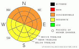
Danger Rose Tutorial
|
Great skiing and riding conditions, abound but sunny side slopes got warm yesterday and are likely to be crusty. CONSIDERABLE (Level 3) Avalanche Danger can still be encountered in Mountains of SE Utah. Travel with caution as there is still potential for some big avalanches. |
|
|
CURRENT CONDITIONS |

|
Santa brought us some excellent skiing and riding conditions for Christmas. We ended up doing pretty well in the La Sals in this last storm although there was a 72-hour period of nothing but clouds and wind with more riming of rocks and trees than I have ever seen. The Abajos picked up massive amounts of snow and water. Abajo snow and water totals are from 8800 ft., - right near the rain/snow line - so how much snow fell higher is unknown, but surely it's deep! South facing slopes got a bit baked yesterday with 35 degree temperatures at 11,700 ft. They are bound to be crusty today. Shadier aspects will be your best bet for turns today.
Storm totals if you missed 'em Friday:Very dense snow w/ high water content.
La Sal Snotel: 13" snow, 2.3" water - lot's of scouring here during this storm it appears.
Gold Basin (La Sals): 21.5" snow, 4.2" water - even more snow near SE side of the range
Camp Jackson Snotel (Abajos) 25" snow, 7.1" water - possibly some rain here in this mix
The road to the Geyser Pass Trailhead has not been plowed yet but is passable by a 4 Wheel Drive rig.
Cross-country ski grooming was done on Friday into Gold Basin and on the Lower Nordic Loops. Both Skate ski and classic x-country tracks have been done. It is a bit rough on the lower part of the Geyser Pass road from a 4-track Dr. Seuss vehicle that's been running around up there leaving deeper ruts than a typical snowmobile. |
|
|
RECENT ACTIVITY |

|
Spectacular viewing Friday from Pre-Laurel peak wx-station. Lots of Avalanches on display. Pretty near all the north facing slopes in Gold Basin have produced avalanches at some time during the storm. Horse Creek also. Many are mostly covered up having run early in the storm but some ran later and are highly visible. Most impressive is the Mt. Peale slide that appears to be about a mile wide. Here's some photos:
Mt. Peale and Laurel Cirque - Mt. Peale avi is on upper ridge in the shade of this photo, Laurel Cirque avi is in the foreground on the sunnier slope.
Talking Mountain Cirque - Most of the bowl came out - several photos
Additional Class 2-3 activity in Middle Cirque, Tuk N. Face, Tukno NE face in both Tele-heaven and Tele-Gold, Exxon's Folley and Noriega's Face. |
|
|
THREAT #1 |

|
| WHERE |
PROBABILITY |
SIZE |
TREND |
|
|
|
|
| |
|
|
Over the next
48 hours.
|
|
|
The cold temperatures that followed the storm seem to have locked things up a bit, bringing down the avalanche danger a notch. Cracking and collapsing have subsided and the snowpack has literally quieted down. This indicates increasing stability.
It is however, far from "green light" conditions. We are 48 hours out from a massive storm that has deposited deep, heavy slabs of snow over a weak underlying base. The possibility for large human triggered avalanches still exists. This is a time when we like to call conditions "Scary CONSIDERABLE" or Scary MODERATE" because the avalanche you might trigger, although not statistically probable, might have serious consequences.
On shady E-NE-NW facing slopes that have not avalanched yet, expect to find a CONSIDERABLE (Level 3) Avalanche Danger. Expect to find a MODERATE (Level 2) avalanche danger elsewhere. Keep an eye on daytime heating on sunny slopes as things might get quite warm ahead of the next set of snow flurries we are expecting tonight. |
|
|
MOUNTAIN WEATHER |

|
National Weather Service Forecast for 10,000 feet: More snow flurries on the way.
Today: A 20 percent chance of snow after 11am. Partly sunny, with a high near 36. South southeast wind 10 to 15 mph becoming west southwest. Tonight: A 40 percent chance of snow. Mostly cloudy, with a low around 20. West southwest wind around 5 mph. Monday: A 20 percent chance of snow. Partly sunny, with a high near 32. West northwest wind between 5 and 10 mph. Monday Night: Partly cloudy, with a low around 18. North northwest wind around 5 mph. Tuesday: Mostly sunny, with a high near 33. North northeast wind 5 to 15 mph becoming west. Tuesday Night: Mostly cloudy, with a low around 20. Wednesday: Snow. High near 27. Breezy. Chance of precipitation is 80%. Wednesday Night: Snow likely. The snow could be heavy at times. Cloudy and windy, with a low around 15. Thursday: A chance of snow. Cloudy, with a high near 15. |
|
|
GENERAL ANNOUNCEMENTS |
The LSAC will be offering 2 avalanche classes this year. Our yearly Level 1 class will be held January 28, 29 and 30 of this winter season. The level 1 class focuses on avalanche phenomena, recognition and management of terrain where you might encounter these beasts and basic rescue.
This season, if we can pick up 6 participants, we are also hoping to do a Level 2 class. Tenative dates for the class are February 3-6. It is a 4-day class reviewing the basics covered in level 1, then carrying the subject matter further, exploring snowpack formation, crystal analysis, climactic effects and advanced rescue.
Call 435-636-3363 and speak to Dave or Max for more information or to sign up for one of the classes. |
|
|
This information does not apply to developed ski areas or highways where avalanche control is normally done. This advisory is from the U.S.D.A. Forest Service, which is solely responsible for its content. This advisory describes general avalanche conditions and local variations always occur. |
|
This advisory provided by the USDA Forest Service, in partnership with:
The Friends of the Utah Avalanche Center, Utah Division of State Parks and Recreation, Utah Division of Emergency Management, Salt Lake County, Salt Lake Unified Fire Authority and the friends of the La Sal Avalanche Center. See our Sponsors Page for a complete list. |
