SPECIAL ANNOUNCEMENT |
 |
Happy Holidays from Dave and Max at the Avi Center! |
|
|
BOTTOM LINE
Danger by aspect and elevation on slopes approaching 35° or steeper.
(click HERE for tomorrow's danger rating)
|
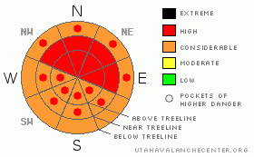
Danger Rose Tutorial
|
While we've allowed the Avalanche Warning to expire for SE Utah mountains that does not mean the switch has been flipped and Avalanche Dangers turned off. There are areas - upper elevation E-NE-NW facing slopes where HIGH(LEVEL4) avalanche dangers can still be found. CONSIDERABLE (LEVEL3) Avalanche Danger can be expected in all other steep mountain terrain in SE Utah steeper than 30 degrees.
Conditions are excellent but the snowpack is tender. Practice extreme caution in the backcountry today and this weekend. Avoid avalanche slopes and runout zones. Today will be the first sunny day after the storm, the traditional day for avalanche accidents...don't let "powder fever" cloud your good judgment. |
|
|
CURRENT CONDITIONS |

|
Deep snow has swallowed up the La Sal and Abajo mountains this past week. Snow densities have gone down towards the end of the storm and conditions are primo. Great skiing and riding conditions are on tap here in SE Utah for the holidays, but with the improvement in our situation comes elevated risk of exposure to snow slides. That is often the law of the mountains and it applies to our current situation. During this storm, water totals in the Abajo Mountains have gone from 37% of normal to 177%. We've had a staggering 7.1 inches of water down there and 4.2 inches in the La Sals. These are big loads being applied to the snowpack here folks, so when you go out in the mountains to enjoy your new Christmas toys, practice common sense route finding and keep the slope angles down!
La Sal Snotel: 13" snow, 2.3" water - lot's of scouring here during this storm it appears.
Gold Basin (La Sals): 21.5" snow, 4.2" water - even more snow near SE side of the range
Camp Jackson Snotel (Abajos) 25" snow, 7.1" water - possibly some rain here in this mix
Remember folks, it's the water weight, not the snow depth that applies the load that causes avalanching. We are well over critical values for snow slides in both the La Sals and the Abajos.
The road to the Geyser Pass Trailhead has not been plowed yet but is passable by a 4 Wheel Drive rig.
Cross-country ski grooming is scheduled for Friday. |
|
|
RECENT ACTIVITY |

|
Limited visibility - Geyser roadcuts have slid naturally. Hoping to get a good look today. |
|
|
THREAT #1 |

|
| WHERE |
PROBABILITY |
SIZE |
TREND |

|
|
|
|
| |
|
|
Over the next
24 hours.
|
|
|
High elevation East through Northeast through Northwest facing slopes where SW winds throughout the storm will have drifted the most snow will be most dangerous today. Loading, cross loading, a change in the snow when the sun comes out and general instability can ALL be expected today. No Joke here, this is NOT the time to expose yourself to ANY avalanche danger.
Snowpit tests from the La Sals Wed. showed extreme instability with columns collapsing in isolation on faceted crystals at the old/new snow interface. We've had another 6" of snow since then. Lot's of cracking and collapsing, and the collapses sounded DEEP. They reverberated on and on like a big thunderclap. Take heed here, these sounds are truly a warning.
Please make conservative decisions in the SE Utah backcountry today. 6-9 foot deep avalanche are being reported in the San Juan Mountains to our east with similar new snow loads and a similar old snowpack. |
|
|
THREAT #2 |

|
| WHERE |
PROBABILITY |
SIZE |
TREND |

|
|
|
|
| |
|
|
Over the next
48 hours.
|
|
|
Check out our last snowpit from above Dark Canyon Lake here. Way scary.
High winds stacking up stiff slabs over old, faceted snow is a classic SE Utah recipe for long lasting instabilities. Expect the tender situation in SE Utah to last a bit longer than usual with this combo. Just because the avalanche warning has been dropped for the SE Utah mountains does not mean it is a green light snowpack situation up there either!
|
|
|
MOUNTAIN WEATHER |

|
National Weather Service Forecast for 10,000 feet: Snow tapering off today.
Today: Sunny, with a high near 39. East wind around 5 mph becoming northwest.
Tonight: Mostly clear, with a low around 21. North northwest wind around 5 mph becoming east southeast.
Christmas Day: Sunny, with a high near 39. South southeast wind around 5 mph becoming calm.
Saturday Night: Partly cloudy, with a low around 27. Calm wind becoming southeast between 5 and 10 mph.
Sunday: A 20 percent chance of snow. Partly sunny, with a high near 38. Southwest wind around 10 mph.
Sunday Night: A 20 percent chance of snow. Mostly cloudy, with a low around 19.
Monday: A 20 percent chance of snow. Partly sunny, with a high near 33.
Monday Night: Mostly cloudy, with a low around 20.
Tuesday: A slight chance of snow. Partly sunny, with a high near 31. |
|
|
GENERAL ANNOUNCEMENTS |
The LSAC will be offering 2 avalanche classes this year. Our yearly Level 1 class will be held January 28, 29 and 30 of this winter season. The level 1 class focuses on avalanche phenomena, recognition and management of terrain where you might encounter these beasts and basic rescue.
This season, if we can pick up 6 participants, we are also hoping to do a Level 2 class. Tenative dates for the class are February 3-6. It is a 4-day class reviewing the basics covered in level 1, then carrying the subject matter further, exploring snowpack formation, crystal analysis, climactic effects and advanced rescue.
Call 435-636-3363 and speak to Dave or Max for more information or to sign up for one of the classes. |
|
|
This information does not apply to developed ski areas or highways where avalanche control is normally done. This advisory is from the U.S.D.A. Forest Service, which is solely responsible for its content. This advisory describes general avalanche conditions and local variations always occur. |
|
This advisory provided by the USDA Forest Service, in partnership with:
The Friends of the Utah Avalanche Center, Utah Division of State Parks and Recreation, Utah Division of Emergency Management, Salt Lake County, Salt Lake Unified Fire Authority and the friends of the La Sal Avalanche Center. See our Sponsors Page for a complete list. |
