AVALANCHE WARNING »
Dangerous avalanche conditions are occuring or are imminent.
Backcountry travel in avalanche terrain is not recommended.
|
 |
Notice: Areas of SE Utah have received 1 to 2 feet of heavy, wet snow in the past 72 hours. More snow is expected over the region for the next two days with periods of intense snow and high winds. This new snow is falling on a very weak layer of old snow creating dangerous avalanche conditions on steep mountain slopes. Avalanche dangers will continue to rise over the next 2 days as a southern storm track brings intense precipitation to Southern Utah and Colorado.
Continued heavy snowfall and high winds will push the Avalanche Danger Rating to HIGH (LEVEL 4). Large and destructive avalanches are likely to occur over the next few days. Backcountry travelers must avoid avalanche slopes and runout zones. |
|
|
BOTTOM LINE
Danger by aspect and elevation on slopes approaching 35° or steeper.
(click HERE for tomorrow's danger rating)
|
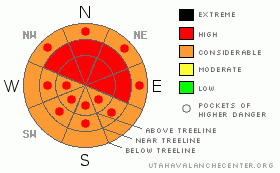
Danger Rose Tutorial
|
Dense Snow and High winds are forecast to continue hammering SE Utah for the next two days. Don't let powder fever hamper your good judgment! Avalanche Dangers in SE Utah are still critical and the Avalanche Danger Rating remains at HIGH or Level 4. This snow is dense enough that steep slopes aren't essential for good skiing and riding so keep the slope angle below 30 degrees. |
|
|
CURRENT CONDITIONS |

|
The snow that had started out with so much promise last Sunday has tapered off in the La Sal Mountains but the Abajo Mountains have closed the gap with more steady snow down south over the last 48 hours. More snow, in large amounts, remains in the forecast for the next 2 days. Storm totals so far:
La Sal Snotel: 9" snow, 1.6" water
Gold Basin (La Sals): 13" snow, 2.1" water
Camp Jackson Snotol (Abajos) 10" snow, 1.9" water
Remember folks, it's the water weight, not the snow depth that applies the load that causes avalanching. We are well over critical values for snow slides.
The road to the Geyser Pass Trailhead was plowed by SJ County yesterday. Thanks Guys!
Cross-country ski grooming is scheduled for Friday. |
|
|
RECENT ACTIVITY |

|
Limited visibility - Geyser roadcuts have slid naturally. |
|
|
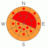
THREAT #1 |

|
| WHERE |
PROBABILITY |
SIZE |
TREND |
|
|
|
|
| |
|
|
Over the next
48 hours.
|
|
|
In areas where winds have deposited the most snow we can expect to find a HIGH (LEVEL 4) avalanche danger. The most dangerous zones will be steep East through Northeast through Northwest facing slopes at and above treeline. Elsewhere CONSIDERABLE (LEVEL3) avalanche dangers can be expected.
More snow has fallen in the Abajos than in the La Sals for the last 48 hours so things might be more sensitive down south. Heads up in North Wash! More snow is expected across SE Utah so be ready. |
|
|
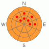
THREAT #2 |

|
| WHERE |
PROBABILITY |
SIZE |
TREND |
|
|
|
|
| |
|
|
Over the next
24
hours.
|
|
|
High winds stacking up stiff slabs over old, faceted snow is a classic SE Utah recipe for long lasting instabilities. Expect the tender situation in SE Utah to last a bit longer than usual with this combo.
Check out our last snowpit from Sunday here. |
|
|
MOUNTAIN WEATHER |

|
National Weather Service Forecast for 10,000 feet: More snow through Thursday
Today: Snow and areas of blowing snow. High near 35. Breezy, with a southwest wind between 20 and 25 mph, with gusts as high as 45 mph. Chance of precipitation is 100%. Total daytime snow accumulation of 11 to 17 inches possible. Tonight: Snow and areas of blowing snow. Low around 28. Southwest wind around 15 mph, with gusts as high as 30 mph. Chance of precipitation is 80%. New snow accumulation of 8 to 12 inches possible. Wednesday: Snow and areas of blowing snow. High near 39. Breezy, with a south southwest wind between 15 and 25 mph, with gusts as high as 35 mph. Chance of precipitation is 90%. New snow accumulation of 10 to 14 inches possible. Wednesday Night: Snow. Low around 24. Windy, with a south southwest wind between 25 and 35 mph, with gusts as high as 55 mph. Chance of precipitation is 100%. New snow accumulation of 4 to 8 inches possible. Thursday: Snow, mainly before 11am. High near 33. Breezy, with a southwest wind 15 to 20 mph decreasing to between 5 and 10 mph. Winds could gust as high as 35 mph. Chance of precipitation is 80%. Thursday Night: A 20 percent chance of snow. Partly cloudy, with a low around 20. Friday: Mostly sunny, with a high near 34. Friday Night: Mostly clear, with a low around 17. Christmas Day: Sunny, with a high near 36. |
|
|
GENERAL ANNOUNCEMENTS |
The LSAC will be offering 2 avalanche classes this year. Our yearly Level 1 class will be held January 28, 29 and 30 of this winter season. The level 1 class focuses on avalanche phenomena, recognition and management of terrain where you might encounter these beasts and basic rescue.
This season, if we can pick up 6 participants, we are also hoping to do a Level 2 class. Tenative dates for the class are February 3-6. It is a 4-day class reviewing the basics covered in level 1, then carrying the subject matter further, exploring snowpack formation, crystal analysis, climactic effects and advanced rescue.
Call 435-636-3363 and speak to Dave or Max for more information or to sign up for one of the classes. |
|
|
This information does not apply to developed ski areas or highways where avalanche control is normally done. This advisory is from the U.S.D.A. Forest Service, which is solely responsible for its content. This advisory describes general avalanche conditions and local variations always occur. |
|
This advisory provided by the USDA Forest Service, in partnership with:
The Friends of the Utah Avalanche Center, Utah Division of State Parks and Recreation, Utah Division of Emergency Management, Salt Lake County, Salt Lake Unified Fire Authority and the friends of the La Sal Avalanche Center. See our Sponsors Page for a complete list. |
