AVALANCHE WARNING »
Dangerous avalanche conditions are occuring or are imminent.
Backcountry travel in avalanche terrain is not recommended.
|
 |
Notice: Areas of SE Utah have received 1 to 2 feet of heavy, wet snow in the past 48 hours. More snow is expected over the region for the next two days with periods of intense snow and high winds. This new snow is falling on a very weak layer of old snow creating dangerous avalanche conditions on steep mountain slopes. Avalanche dangers will continue to rise over the next 2 days as a southern storm track brings intense precipitation to Southern Utah and Colorado.
Continued heavy snowfall and high winds will push the Avalanche Danger Rating to HIGH (LEVEL 4). Large and destructive avalanches are likely to occur over the next few days. Backcountry travelers must avoid avalanche slopes and runout zones. |
|
|
BOTTOM LINE
Danger by aspect and elevation on slopes approaching 35° or steeper.
(click HERE for tomorrow's danger rating)
|
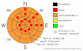
Danger Rose Tutorial
|
Very dense snow is improving skiing and riding conditions across the Southwest and here in SE Utah as well. Expect to find CONSIDERABLE (level 3) to HIGH (level 4) avalanche danger in mountain terrain in SE Utah. Stay clear of Avalanche Paths and Runout zones. |
|
|
CURRENT CONDITIONS |

|
Very heavy, dense snow is the theme of this storm so far with snow densities measured in the 18-22% percent range. This is much heavier than our normal 5-10% densities and what that means is that this snow really packs a punch. The highest density snow was measured at the end of the day yesterday and the snow we've received is a little bit inverted but skied pretty well. This dense new snow will help our base in the SE Utah Mountains significantly. Snowfall rates dwindled yesterday and did not reach even the low end of forecast amounts, but snowfall is kicking in again as we speak and high winds have not let up. Snow totals so far -Gold Basin 12" new snow 1.9" water. Geyser Pass Snotel 9", 1.5" water, Camp Jackson (Abajo Mtns.) 9" snow, 1.9" water.
The road to the Geyser Pass Trailhead has not been plowed but it was pretty well packed out yesterday by traffic. 4wd required.
Grooming eradicated but all lower trails are marked and the grooming program is underway. Grooming scheduled for Friday. |
|
|
RECENT ACTIVITY |

|
Limited visibility - Geyser roadcuts have slid naturally. |
|
|
THREAT #1 |

|
| WHERE |
PROBABILITY |
SIZE |
TREND |
|
|
|
|
| |
|
|
Over the next
48 hours.
|
|
|
Snowfall rates did not live up to expectations yesterday but very sensitive avalanche conditions continue across SE Utah with dense new snow and wind forming potentially destructive slabs over old, weak, faceted snow. We did spot some slides down low yesterday on our tour but up high we were in the milk bottle with no visibility at all. Despite the relatively unimpressive snow totals, water totals for this storm are impressive and more is on the way. It is the water weight in the snow that applies the actual stress to the snowpack and what we've received so far is well beyond critical values for slab avalanche formation.
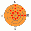
On our tour yesterday we saw lots of cracking, heard "whoomphing" as the snowpack collapsed around us and found very weak snow in our snowpit tests. At the top of the Coyote Chute, columns of new snow were failing on isolation indicating high avalanche danger. We are keeping the avalanche danger "in the red" with pockets of HIGH (Level 4) avalanche danger on E-NE-NW facing slopes. The Avalanche Danger remains CONSIDERABLE (Level 3) everywhere else but may be locally more intense due to wind drifting. Big snow amounts remain in the forecast at the moment so the avalanche danger is likely to increase over the next 2 days. Keep the slope angles under 30 degrees if you are heading out into the backcountry. |
|
|
MOUNTAIN WEATHER |

|
Forecast for 10,000 feet: More snow through Wed.
Today: Snow and areas of blowing snow. High near 35. Breezy, with a west southwest wind between 15 and 25 mph. Chance of precipitation is 100%. Total daytime snow accumulation of 4 to 8 inches possible. Tonight: Snow and areas of blowing snow. Low around 26. Breezy, with a southwest wind between 15 and 20 mph. Chance of precipitation is 100%. New snow accumulation of 5 to 9 inches possible. Tuesday: Snow. High near 35. Breezy, with a southwest wind between 20 and 25 mph. Chance of precipitation is 90%. New snow accumulation of 3 to 7 inches possible. Tuesday Night: Snow. Low around 26. Windy, with a south southwest wind between 25 and 30 mph, with gusts as high as 45 mph. Chance of precipitation is 80%. New snow accumulation of 1 to 3 inches possible. Wednesday: Snow. High near 35. Breezy, with a south wind between 15 and 20 mph. Chance of precipitation is 80%. Wednesday Night: Snow. Low around 22. Breezy. Chance of precipitation is 80%. Thursday: A 50 percent chance of snow. Mostly cloudy, with a high near 32. Thursday Night: A slight chance of snow. Partly cloudy, with a low around 15. |
|
|
GENERAL ANNOUNCEMENTS |
The LSAC will be offering 2 avalanche classes this year. Our yearly Level 1 class will be held January 28, 29 and 30 of this winter season. The level 1 class focuses on avalanche phenomena, recognition and management of terrain where you might encounter these beasts and basic rescue.
This season, if we can pick up 6 participants, we are also hoping to do a Level 2 class. Tenative dates for the class are February 3-6. It is a 4-day class reviewing the basics covered in level 1, then carrying the subject matter further, exploring snowpack formation, crystal analysis, climactic effects and advanced rescue.
Call 435-636-3363 and speak to Dave or Max for more information or to sign up for one of the classes. |
|
|
This information does not apply to developed ski areas or highways where avalanche control is normally done. This advisory is from the U.S.D.A. Forest Service, which is solely responsible for its content. This advisory describes general avalanche conditions and local variations always occur. |
|
This advisory provided by the USDA Forest Service, in partnership with:
The Friends of the Utah Avalanche Center, Utah Division of State Parks and Recreation, Utah Division of Emergency Management, Salt Lake County, Salt Lake Unified Fire Authority and the friends of the La Sal Avalanche Center. See our Sponsors Page for a complete list. |
